Touchet River
Encyclopedia


Walla Walla River
The Walla Walla River is a tributary of the Columbia River, joining the Columbia just above Wallula Gap in southeastern Washington in the United States. The river flows through Umatilla County, Oregon and Walla Walla County, Washington. Its drainage basin is in area.-Course:The headwaters of the...
in southeastern Washington in the United States
United States
The United States of America is a federal constitutional republic comprising fifty states and a federal district...
.
The upper Touchet was a traditional summer meeting place for trade and games for the Palus
Palus (tribe)
The Palus are a Sahaptin tribe recognized in the Treaty of 1855 with the Yakamas . A variant spelling is Palouse, which was the source of the name for the fertile prairie of Washington and Idaho.- Ethnography :...
, Nez Perce and Walla Walla
Walla Walla (tribe)
Walla Walla |Native American]] tribe of the northwestern United States. The reduplication of the word expresses the diminutive form. The name "Walla Walla" is translated several ways but most often as "many waters."...
tribes. The name Touchet derives from the similarly pronounced Sahaptin
Sahaptin language
Sahaptin , Sħáptənəxw, is a Plateau Penutian language of the Sahaptian branch spoken in a section of the northwestern plateau along the Columbia River and its tributaries in southern Washington, northern Oregon, and southwestern Idaho....
term for the river, Tu-se meaning roasting. Nez Perce legend tells that coyote roasted salmon
Salmon
Salmon is the common name for several species of fish in the family Salmonidae. Several other fish in the same family are called trout; the difference is often said to be that salmon migrate and trout are resident, but this distinction does not strictly hold true...
at this river after breaking a fish dam guarded by the seven swallow sisters at Celilo
Celilo Falls
Celilo Falls was a tribal fishing area on the Columbia River, just east of the Cascade Mountains, on what is today the border between the U.S. states of Oregon and Washington...
.
The USGS cited two variant names, Pouchet River and Toosha River.
Geography
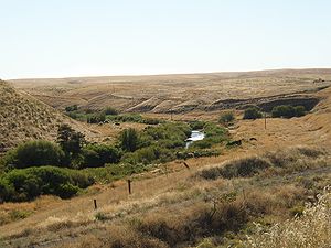
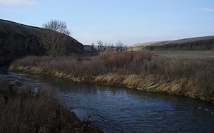
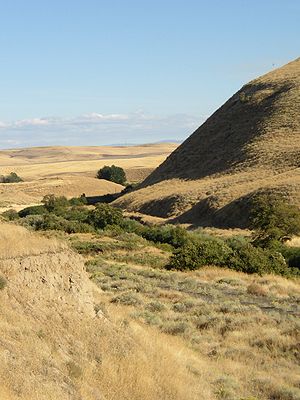
The Touchet River drains an area of approximately 740 square miles (1,916.6 km²). It is 137 km (85.1 mi) in length. The average annual flow of the Touchet is 6.23 m³/s (220 ft³/s), not including diversions.Its headwaters lie in the Umatilla National Forest
Umatilla National Forest
The Umatilla National Forest, in the Blue Mountains of northeast Oregon and southeast Washington, covers an area of 1.4 million acres . In descending order of land area the forest is located in parts of Umatilla, Grant, Columbia, Morrow, Wallowa, Union, Garfield, Asotin, Wheeler, and Walla Walla...
which is located in the Blue Mountains
Blue Mountains (Oregon)
The Blue Mountains are a mountain range in the western United States, located largely in northeastern Oregon and stretching into southeastern Washington...
in Columbia County, southern Washington. It originates above the town of Dayton, Washington
Dayton, Washington
Dayton is a city in and the county seat of Columbia County, Washington, United States. The population was 2,526 at the 2010 census.-History:...
. It then passes through Waitsburg and Prescott
Prescott, Washington
Prescott is a town in central Walla Walla County, Washington. The population was 318 at the 2010 census.-History:Prescott was named in 1881 after C.H...
before joining the Walla Walla at the town of Touchet, Washington
Touchet, Washington
Touchet is a census-designated place in Walla Walla County, Washington, United States. The population was 421 at the 2010 census.-History:Original inhabitants of the Walla Walla valley were the Nimi'ipuu people...
.
The main Touchet River is formed by the confluence of the North Fork of the Touchet which originates in the vicinity of the Bluewood Ski Area
Bluewood Ski Area
Ski Bluewood, formerly known as "Bluewood Ski Area," is an alpine ski area in southeastern Washington, United States. Located in Columbia County, at the northern end of the Blue Mountains in the Umatilla National Forest, the elevation at the base area is above sea level, with a summit of...
, and the South Fork of the Touchet which originates at Deadman Peak. The forks join approximately 3.2 km (2 mi) south of (upstream of) Dayton. The North Fok is approximately 40 km (24.9 mi) long while the South Fork is approximately 32 km (19.9 mi) long. Other tributaries include:
- Patit Creek, which joins the Touchet at Dayton
- Coppei Creek, which joins the Touchet at Waitsburg
- Whetstone Creek, which joins the Touchet at Prescott
Recreation
The Touchet is known for its trout fishing, especially in the upper reaches.Although (summer steelhead, which like salmon
Salmon
Salmon is the common name for several species of fish in the family Salmonidae. Several other fish in the same family are called trout; the difference is often said to be that salmon migrate and trout are resident, but this distinction does not strictly hold true...
are anadromous, and Chinook salmon
Chinook salmon
The Chinook salmon, Oncorhynchus tshawytscha, is the largest species in the pacific salmon family. Other commonly used names for the species include King salmon, Quinnat salmon, Spring salmon and Tyee salmon...
) spawned throughout a large portion of the middle and upper reaches of the Touchet River drainage, the population is virtually nonexistent in the 21st century. The Nine Mile Dam, constructed in 1905 on the Walla Walla River below the confluence with the Touchet River, ended anadromous fish migration into the Touchet.
Native peoples

Palus (tribe)
The Palus are a Sahaptin tribe recognized in the Treaty of 1855 with the Yakamas . A variant spelling is Palouse, which was the source of the name for the fertile prairie of Washington and Idaho.- Ethnography :...
, marking their southern border with the range of the Walla Walla tribe
Walla Walla (tribe)
Walla Walla |Native American]] tribe of the northwestern United States. The reduplication of the word expresses the diminutive form. The name "Walla Walla" is translated several ways but most often as "many waters."...
. These peoples were of the Sahaptin
Sahaptin language
Sahaptin , Sħáptənəxw, is a Plateau Penutian language of the Sahaptian branch spoken in a section of the northwestern plateau along the Columbia River and its tributaries in southern Washington, northern Oregon, and southwestern Idaho....
-speaking group which traditionally inhabited the Columbia Plateau
Columbia Plateau
The Columbia Plateau is a geologic and geographic region that lies across parts of the U.S. states of Washington, Oregon, and Idaho. It is a wide flood basalt plateau between the Cascade Range and the Rocky Mountains, cut through by the Columbia River...
region of the northwestern United States.
Roots provided plentiful food along the Touchet Rivers. These included quamash
Quamash
Quamash , also known as Small Camas, is a perennial herb. It is one species of the genus Camassia and is native to western North America in large areas of southern Canada and the northwestern United States, from British Columbia and Alberta to California and east from Washington state to Montana...
, camas
Camassia
Camassia is a genus of six species native to western North America, from southern British Columbia to northern California, and east to Utah, Wyoming and Montana...
, kouse, bitterroot
Bitterroot
Bitterroot is a small, low plant with a pink to white flower. It is the state flower of Montana, United States....
s, serviceberry
Serviceberry
Amelanchier , also known as shadbush, shadwood or shadblow, serviceberry or sarvisberry, wild pear, juneberry, saskatoon, sugarplum or wild-plum, and chuckley pear is a genus of about 20 species of deciduous-leaved shrubs and small trees in the Rose family .Amelanchier is native to temperate regions...
(currant), chokecherry
Chokecherry
Prunus virginiana, commonly called chokecherry, bitter-berry, or Virginia bird cherry, is a species of bird cherry native to North America, where it is found almost throughout the continent except for the Deep South and the far north.-Growth:It is a suckering shrub or small tree growing to 5 m tall...
, huckleberry
Huckleberry
Huckleberry is a common name used in North America for several species of plants in two closely related genera in the family Ericaceae:* Vaccinium* GaylussaciaHuckleberry may also refer to:-Plants:...
, gooseberries, rose berries and whortleberries, elderberries, wild strawberries
Strawberry
Fragaria is a genus of flowering plants in the rose family, Rosaceae, commonly known as strawberries for their edible fruits. Although it is commonly thought that strawberries get their name from straw being used as a mulch in cultivating the plants, the etymology of the word is uncertain. There...
, wild onion
Wild onion
Wild onion can refer to* any uncultivated species in the genus Allium, especially:**Allium bisceptrum** Allium canadense** Allium validum** Allium vineale* Cyperus bulbosus* Bulbine semibarbata...
s and balsamroot
Balsamorhiza
Balsamorhiza is a genus of plants in the sunflower family known commonly as balsamroots. These are perennials with fleshy taproots and caudices bearing erect stems and large, basal leaves. Atop the tall stems are showy yellow sunflower-like blooms. Balsamroots are native to western North America...
. Once Euroamerican immigrants began settling the area after 1858, Indian root grounds were displaced by agriculture.
Prior to the white man coming into the valley of the Touchet River, there was an established American Indian trail through the valley, the Nez Perce Trail to Celilo Falls or Old Celilo Falls Trail, by which the Nez Perce (also part of the Sahaptin
Sahaptin language
Sahaptin , Sħáptənəxw, is a Plateau Penutian language of the Sahaptian branch spoken in a section of the northwestern plateau along the Columbia River and its tributaries in southern Washington, northern Oregon, and southwestern Idaho....
-speaking group) passed west to fish for salmon
Salmon
Salmon is the common name for several species of fish in the family Salmonidae. Several other fish in the same family are called trout; the difference is often said to be that salmon migrate and trout are resident, but this distinction does not strictly hold true...
at Celilo Falls
Celilo Falls
Celilo Falls was a tribal fishing area on the Columbia River, just east of the Cascade Mountains, on what is today the border between the U.S. states of Oregon and Washington...
on the Columbia River
Columbia River
The Columbia River is the largest river in the Pacific Northwest region of North America. The river rises in the Rocky Mountains of British Columbia, Canada, flows northwest and then south into the U.S. state of Washington, then turns west to form most of the border between Washington and the state...
. As with other Sahaptin-speaking peoples, the Nez Perce were migratory, returning to the same locations year after year; Celilo Falls lay at the western end of their annual range.
Lewis and Clark expedition
On their return journey in 1806, the Lewis and Clark ExpeditionLewis and Clark Expedition
The Lewis and Clark Expedition, or ″Corps of Discovery Expedition" was the first transcontinental expedition to the Pacific Coast by the United States. Commissioned by President Thomas Jefferson and led by two Virginia-born veterans of Indian wars in the Ohio Valley, Meriwether Lewis and William...
followed the Old Celilo Falls Trail, up the Walla Walla and Touchet River Valleys; they camped on the Touchet about 12 miles (19.3 km) north of today's town of Touchet on April 30, 1806. The Lewis and Clark Trail State Park commemorates their May 1, 1806 campsite on the Touchet River. The expedition left the Touchet River to follow a tributary, Patit Creek, at what is now Dayton, Washington. They camped ~ 3 km above modern-day Dayton on Patit Creek on May 2, 1806, before following the trail across country to the Tucannon River
Tucannon River
The Tucannon River is a river in southeastern Washington state that flows from headwaters in the Blue Mountains to a confluence with the Snake River upstream from Lyons Ferry Park and the mouth of the Palouse River. The Tucannon itself drains and is long...
.
Early settlement
The Whitman Mission catalyzed white settlement of the region, beginning in 1843 when 1,000 people, 120 wagons, and approximately 5,000 horses and cattle came to the Walla Walla valley. The initial settlers remained near the current city of Walla Walla and into the Touchet River valley.Later settlement

Winter wheat
Winter wheat is a type of wheat that is planted from September to December in the Northern Hemisphere. Winter wheat sprouts before freezing occurs, then becomes dormant until the soil warms in the spring. Winter wheat needs a few weeks of cold before being able to flower, however persistent snow...
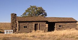
. This area developed into the town of Lamar when the Hunt Railroad was built along the Touchet River valley in 1888. The railway left the Touchet River and continued west at Lamar at the point where the Touchet River turns south to meet the Walla Walla. Although the town site is now virtually abandoned, the historic Lamar cabin is preserved to this day (see photo).
Near the head of the Touchet valley, Dayton, Washington
Dayton, Washington
Dayton is a city in and the county seat of Columbia County, Washington, United States. The population was 2,526 at the 2010 census.-History:...
was officially incorporated on November 10, 1881.
See also
- List of Washington rivers
- List of tributaries of the Columbia River
- Touchet, WashingtonTouchet, WashingtonTouchet is a census-designated place in Walla Walla County, Washington, United States. The population was 421 at the 2010 census.-History:Original inhabitants of the Walla Walla valley were the Nimi'ipuu people...
- Touchet FormationTouchet FormationThe Touchet Formation or Touchet beds consist of large quantities of gravel and fine sediment which overlay almost a thousand meters of volcanic basalt of the Columbia River Basalt Group in south-central Washington and north-central Oregon...

