
Triborough Bridge
Encyclopedia
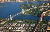
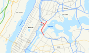
The Robert F. Kennedy Bridge, formerly known as the Triborough Bridge (sometimes spelled Triboro Bridge), is a complex of three separate bridge
s in New York City
, United States
. Spanning the Harlem River
, the Bronx Kill
, and the Hell Gate
(part of the East River
), the bridges connect the borough
s of Manhattan
, Queens
, and The Bronx
via Randall's Island
and Wards Island, which are joined by landfill.
Often still referred to as simply the "Triboro" the spans were officially named after Robert F. Kennedy
in 2008.
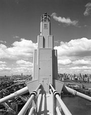
Construction had begun on Black Friday in 1929, and the Triborough project's outlook began to look bleak. Othmar Ammann's
assistance was enlisted to help simplify the structure. Ammann had collapsed the original two-deck roadway into one, requiring lighter towers, and thus, lighter piers. These cost-saving revisions saved $10 million on the towers alone. Using New Deal
money, the project was resurrected in the early 1930s by Robert Moses
and the bridge was opened to traffic on July 11, 1936.
The total cost of the bridge was more than $60 million, greater than that of the Hoover Dam
, and was one of the largest public works projects of the Great Depression
. The structure used concrete from factories from Maine
to Mississippi
. To make the formwork for pouring the concrete, a whole forest on the Pacific Coast
was cut down.
The American Society of Civil Engineers
designated the Triborough Bridge Project as a National Historic Civil Engineering Landmark in 1986. Motorists were first able to pay with E-ZPass
in lanes for automatic coin machines at the Randall's Island toll plazas on August 21, 1996.
At some point in the past, a sign on the bridge informed travelers, "In event of attack, drive off bridge", New York Times columnist William Safire
wrote in 2008. The "somewhat macabre sign", he wrote, must have "drawn a wry smile from millions of motorists."
On November 19, 2008, and pursuant to a request made by the Kennedy family, the Triborough Bridge was officially renamed after Robert F. Kennedy
, who served New York as a senator
, 40 years after his assassination.
On May 5, 2010, the NYPD closed the bridge and sent in the bomb squad to investigate a U-haul
truck from which a man had reportedly fled. This investigation came days after a failed attempt at a car bombing in Times Square
. A short time later, the NYPD deemed this incident nonthreatening and reopened the bridge.
Many traffic and news reports commonly use the name "RFK Triborough Bridge", likely to avoid confusion among residents.
 The toll revenues from the Robert F. Kennedy Bridge pay for a portion of the public transit subsidy for the New York City Transit Authority
and the commuter railroads. The bridge carries approximately 200,000 vehicles per day.
The bridge has sidewalks in all three legs where the TBTA officially requires bicyclists to walk their bicycles across due to safety concerns. However, the signs stating this requirement have been usually ignored by bicyclists, while the New York City Government has recommended that the TBTA should reassess this kind of bicycling ban. Stairs on the 2 km (1.2 mi) Queens leg impede handicapped access. The Queens stairway along the southern side was demolished at the beginning of the 21st century, thus isolating that walkway, but the ramp of the Wards Island end of the walkway along the northern side was improved in 2007. The two sidewalks of the Bronx span are connected to only one ramp at the Randalls Island end.
The Triborough Bridge and Tunnel Authority's most recent toll increase went into effect on December 30, 2010. The cash charge for passenger vehicles to cross the bridge was raised to $6.50 (from $5.50) in any direction. The toll for E-ZPass
users was raised to $4.80 (from $4.57). The crossing charge for a motorcycle increased to $2.75 (from $2.50), with motorcycle tolls with E-ZPass rising to $2.09 (from $1.99). The return trip from Randall's Island to any borough is free.
routes operated by the MTA Bus Company
, the BxM1, BxM2, BxM6, BxM7, BxM8, BxM9, BxM10, BxM11 and BxM18.
Bridge
A bridge is a structure built to span physical obstacles such as a body of water, valley, or road, for the purpose of providing passage over the obstacle...
s in New York City
New York City
New York is the most populous city in the United States and the center of the New York Metropolitan Area, one of the most populous metropolitan areas in the world. New York exerts a significant impact upon global commerce, finance, media, art, fashion, research, technology, education, and...
, United States
United States
The United States of America is a federal constitutional republic comprising fifty states and a federal district...
. Spanning the Harlem River
Harlem River
The Harlem River is a navigable tidal strait in New York City, USA that flows 8 miles between the Hudson River and the East River, separating the boroughs of Manhattan and the Bronx...
, the Bronx Kill
Bronx Kill
The Bronx Kill is a narrow strait in New York City delineating the southernmost extent of the Bronx and separating it from Randall's Island. It connects the Harlem River to the East River.-History:...
, and the Hell Gate
Hell Gate
Hell Gate is a narrow tidal strait in the East River in New York City in the United States. It separates Astoria, Queens from Randall's Island/Wards Island ....
(part of the East River
East River
The East River is a tidal strait in New York City. It connects Upper New York Bay on its south end to Long Island Sound on its north end. It separates Long Island from the island of Manhattan and the Bronx on the North American mainland...
), the bridges connect the borough
Borough (New York City)
New York City, one of the largest cities in the world, is composed of five boroughs. Each borough now has the same boundaries as the county it is in. County governments were dissolved when the city consolidated in 1898, along with all city, town, and village governments within each county...
s of Manhattan
Manhattan
Manhattan is the oldest and the most densely populated of the five boroughs of New York City. Located primarily on the island of Manhattan at the mouth of the Hudson River, the boundaries of the borough are identical to those of New York County, an original county of the state of New York...
, Queens
Queens
Queens is the easternmost of the five boroughs of New York City. The largest borough in area and the second-largest in population, it is coextensive with Queens County, an administrative division of New York state, in the United States....
, and The Bronx
The Bronx
The Bronx is the northernmost of the five boroughs of New York City. It is also known as Bronx County, the last of the 62 counties of New York State to be incorporated...
via Randall's Island
Randall's Island
Randall's Island is situated in the East River in New York City, part of the borough of Manhattan. It is separated from Manhattan island on the west by the river's main channel, from Queens on the east by the Hell Gate, and from the Bronx on the north by the Bronx Kill. It is joined to Wards...
and Wards Island, which are joined by landfill.
Often still referred to as simply the "Triboro" the spans were officially named after Robert F. Kennedy
Robert F. Kennedy
Robert Francis "Bobby" Kennedy , also referred to by his initials RFK, was an American politician, a Democratic senator from New York, and a noted civil rights activist. An icon of modern American liberalism and member of the Kennedy family, he was a younger brother of President John F...
in 2008.
History
Plans for connecting Manhattan, Queens and the Bronx were first announced by Edward A. Byrne, chief engineer of the New York City Department of Plant and Structures, in 1916. While its construction had been long recommended by local officials, the Triborough Bridge did not receive any funding until 1925, when the city appropriated funds for surveys, test borings and structural plans.Construction had begun on Black Friday in 1929, and the Triborough project's outlook began to look bleak. Othmar Ammann's
Othmar Ammann
Othmar Hermann Ammann was a American structural engineer whose designs include the George Washington Bridge, Verrazano-Narrows Bridge, and Bayonne Bridge.-Biography:...
assistance was enlisted to help simplify the structure. Ammann had collapsed the original two-deck roadway into one, requiring lighter towers, and thus, lighter piers. These cost-saving revisions saved $10 million on the towers alone. Using New Deal
New Deal
The New Deal was a series of economic programs implemented in the United States between 1933 and 1936. They were passed by the U.S. Congress during the first term of President Franklin D. Roosevelt. The programs were Roosevelt's responses to the Great Depression, and focused on what historians call...
money, the project was resurrected in the early 1930s by Robert Moses
Robert Moses
Robert Moses was the "master builder" of mid-20th century New York City, Long Island, Rockland County, and Westchester County, New York. As the shaper of a modern city, he is sometimes compared to Baron Haussmann of Second Empire Paris, and is one of the most polarizing figures in the history of...
and the bridge was opened to traffic on July 11, 1936.
The total cost of the bridge was more than $60 million, greater than that of the Hoover Dam
Hoover Dam
Hoover Dam, once known as Boulder Dam, is a concrete arch-gravity dam in the Black Canyon of the Colorado River, on the border between the US states of Arizona and Nevada. It was constructed between 1931 and 1936 during the Great Depression and was dedicated on September 30, 1935, by President...
, and was one of the largest public works projects of the Great Depression
Great Depression in the United States
The Great Depression began with the Wall Street Crash of October, 1929 and rapidly spread worldwide. The market crash marked the beginning of a decade of high unemployment, poverty, low profits, deflation, plunging farm incomes, and lost opportunities for economic growth and personal advancement...
. The structure used concrete from factories from Maine
Maine
Maine is a state in the New England region of the northeastern United States, bordered by the Atlantic Ocean to the east and south, New Hampshire to the west, and the Canadian provinces of Quebec to the northwest and New Brunswick to the northeast. Maine is both the northernmost and easternmost...
to Mississippi
Mississippi
Mississippi is a U.S. state located in the Southern United States. Jackson is the state capital and largest city. The name of the state derives from the Mississippi River, which flows along its western boundary, whose name comes from the Ojibwe word misi-ziibi...
. To make the formwork for pouring the concrete, a whole forest on the Pacific Coast
West Coast of the United States
West Coast or Pacific Coast are terms for the westernmost coastal states of the United States. The term most often refers to the states of California, Oregon, and Washington. Although not part of the contiguous United States, Alaska and Hawaii do border the Pacific Ocean but can't be included in...
was cut down.
The American Society of Civil Engineers
American Society of Civil Engineers
The American Society of Civil Engineers is a professional body founded in 1852 to represent members of the civil engineering profession worldwide. It is the oldest national engineering society in the United States. ASCE's vision is to have engineers positioned as global leaders who strive toward...
designated the Triborough Bridge Project as a National Historic Civil Engineering Landmark in 1986. Motorists were first able to pay with E-ZPass
E-ZPass
E-ZPass is an electronic toll-collection system used on most tolled roads, bridges, and tunnels in the northeastern US, south to Virginia and West Virginia, and west to Illinois. Currently, there are 25 agencies spread across 14 states that make up the . All member agencies use the same technology,...
in lanes for automatic coin machines at the Randall's Island toll plazas on August 21, 1996.
At some point in the past, a sign on the bridge informed travelers, "In event of attack, drive off bridge", New York Times columnist William Safire
William Safire
William Lewis Safire was an American author, columnist, journalist and presidential speechwriter....
wrote in 2008. The "somewhat macabre sign", he wrote, must have "drawn a wry smile from millions of motorists."
On November 19, 2008, and pursuant to a request made by the Kennedy family, the Triborough Bridge was officially renamed after Robert F. Kennedy
Robert F. Kennedy
Robert Francis "Bobby" Kennedy , also referred to by his initials RFK, was an American politician, a Democratic senator from New York, and a noted civil rights activist. An icon of modern American liberalism and member of the Kennedy family, he was a younger brother of President John F...
, who served New York as a senator
United States Senate
The United States Senate is the upper house of the bicameral legislature of the United States, and together with the United States House of Representatives comprises the United States Congress. The composition and powers of the Senate are established in Article One of the U.S. Constitution. Each...
, 40 years after his assassination.
On May 5, 2010, the NYPD closed the bridge and sent in the bomb squad to investigate a U-haul
U-Haul
U-Haul International, Inc. is an American equipment rental company, based in Phoenix, Arizona, that has been in operation since 1945. The company was founded by Leonard Shoen U-Haul International, Inc. is an American equipment rental company, based in Phoenix, Arizona, that has been in operation...
truck from which a man had reportedly fled. This investigation came days after a failed attempt at a car bombing in Times Square
Times Square
Times Square is a major commercial intersection in the borough of Manhattan in New York City, at the junction of Broadway and Seventh Avenue and stretching from West 42nd to West 47th Streets...
. A short time later, the NYPD deemed this incident nonthreatening and reopened the bridge.
Many traffic and news reports commonly use the name "RFK Triborough Bridge", likely to avoid confusion among residents.
Usage
New York City Transit Authority
The New York City Transit Authority is a public authority in the U.S. state of New York that operates public transportation in New York City...
and the commuter railroads. The bridge carries approximately 200,000 vehicles per day.
The bridge has sidewalks in all three legs where the TBTA officially requires bicyclists to walk their bicycles across due to safety concerns. However, the signs stating this requirement have been usually ignored by bicyclists, while the New York City Government has recommended that the TBTA should reassess this kind of bicycling ban. Stairs on the 2 km (1.2 mi) Queens leg impede handicapped access. The Queens stairway along the southern side was demolished at the beginning of the 21st century, thus isolating that walkway, but the ramp of the Wards Island end of the walkway along the northern side was improved in 2007. The two sidewalks of the Bronx span are connected to only one ramp at the Randalls Island end.
The Triborough Bridge and Tunnel Authority's most recent toll increase went into effect on December 30, 2010. The cash charge for passenger vehicles to cross the bridge was raised to $6.50 (from $5.50) in any direction. The toll for E-ZPass
E-ZPass
E-ZPass is an electronic toll-collection system used on most tolled roads, bridges, and tunnels in the northeastern US, south to Virginia and West Virginia, and west to Illinois. Currently, there are 25 agencies spread across 14 states that make up the . All member agencies use the same technology,...
users was raised to $4.80 (from $4.57). The crossing charge for a motorcycle increased to $2.75 (from $2.50), with motorcycle tolls with E-ZPass rising to $2.09 (from $1.99). The return trip from Randall's Island to any borough is free.
Public transportation
The RFK Bridge carries the M35 and M60 local bus routes operated by MTA New York City Transit, and nine express busExpress bus
An express bus service is a bus service that is intended to run faster than normal bus services between the same two commuter points....
routes operated by the MTA Bus Company
MTA Bus Company
MTA Bus Company is a service of MTA Regional Bus Operations used on routes previously controlled by the New York City Department of Transportation , and operated by private operators that provided service under contract to the NYCDOT...
, the BxM1, BxM2, BxM6, BxM7, BxM8, BxM9, BxM10, BxM11 and BxM18.
East River suspension bridge (I-278)
- Span crosses the East River at the Hell Gate between Queens and Wards Island
- Connects to Grand Central ParkwayGrand Central ParkwayThe Grand Central Parkway is a parkway that stretches from the RFK-Triborough Bridge in New York City to Nassau County on Long Island. At the Queens-Nassau border, it becomes the Northern State Parkway, which runs across the northern part of Long Island through Nassau County and into Suffolk...
and Brooklyn-Queens Expressway - Length of main span: 1,380 feet (421 m)
- Length of each side span: 700 feet (213 m)
- Length, anchorage to anchorage: 2,780 feet (847 m)
- Width of bridge: 98 feet (30 m)
- Number of traffic lanes: 8 lanes
- Height of towers above mean high water: 315 feet (96 m)
- Clearance at center above mean high water: 143 feet (44 m)
- Number of sidewalks: 1
Harlem River lift bridge (NY Reference Route 900G)
- Span crosses the Harlem River between Manhattan and Randall's Islands
- Connects to Harlem River DriveHarlem River DriveThe Harlem River Drive is a north–south parkway in the New York City borough of Manhattan. It runs along the west bank of the Harlem River from the Triborough Bridge in East Harlem to 10th Avenue in Inwood, where the parkway continues north as Dyckman Street. The portion of the Harlem River Drive...
, FDR Drive, and 125th Street125th Street (Manhattan)125th Street is a two-way street that runs east-west in the New York City borough of Manhattan, considered the "Main Street" of Harlem; It is also called Martin Luther King, Jr... - Length of main lift-truss span: 310 feet (94 m)
- Length of each side truss span: 230 feet (70 m)
- Length, anchorage to anchorage: 770 feet (235 m)
- Height of towers: 210 feet (64 m)
- Clearance of lift span above mean high water: 55 feet (17 m)
- Clearance of lift span in raised position: 135 feet (41 m)
- Number of traffic lanes: 6 lanes
- Number of sidewalks: 2 (1 on each side)
Bronx Kill crossing (I-278)
- Span crosses the Bronx Kill between The Bronx and Randall's Island
- Connects to Major Deegan ExpresswayMajor Deegan ExpresswayThe Major Deegan Expressway is a north–south expressway in the New York City borough of the Bronx...
and Bruckner ExpresswayBruckner ExpresswayThe Bruckner Expressway is a freeway in The Bronx. It carries Interstate 278 and Interstate 95 from the Robert F. Kennedy Bridge to the south end of the New England Thruway at the Pelham Parkway interchange.... - Length of main truss span: 383 feet (117 m)
- Length of approach truss span: 1,217 feet (371 m)
- Length, anchorage to anchorage: 1,600 feet (488 m)
- Clearance of truss span above mean high water: 55 feet (17 m)
- Number of traffic lanes: 8 lanes
- Number of sidewalks: 2 (1 on each side)