
Tuttington
Encyclopedia
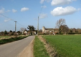
Tuttington is a village is located in the civil parish
of Burgh and Tuttington
, in the English
county of Norfolk
. The village is 11.1 miles south of Cromer
, 15 miles north of Norwich
and 129 miles north-east of London
. The village lies 3 miles east of the nearby town of Aylsham
. The nearest railway station is at North Walsham
for the Bittern Line
which runs between Sheringham
, Cromer and Norwich. The nearest airport is Norwich International Airport
.
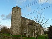
Its church, St Peter and St Paul, is one of 124 existing round-tower church
es in Norfolk
.
Opposite the church, there is a Dutch gabled building that used to be the village shop and post office, which closed in May 1987. Next door to that there used to be a pub called The Ship. It has been said that as the village is several miles from the sea or any navigable waterways, this name could be a corruption of The Sheep as the pub may have been a welcome watering hole for drovers.
Civil parish
In England, a civil parish is a territorial designation and, where they are found, the lowest tier of local government below districts and counties...
of Burgh and Tuttington
Burgh and Tuttington
Burgh and Tuttington is a civil parish in the English county of Norfolk.It covers an area of and had a population of 255 in 115 households as of the 2001 census.For the purposes of local government, it falls within the district of Broadland...
, in the English
England
England is a country that is part of the United Kingdom. It shares land borders with Scotland to the north and Wales to the west; the Irish Sea is to the north west, the Celtic Sea to the south west, with the North Sea to the east and the English Channel to the south separating it from continental...
county of Norfolk
Norfolk
Norfolk is a low-lying county in the East of England. It has borders with Lincolnshire to the west, Cambridgeshire to the west and southwest and Suffolk to the south. Its northern and eastern boundaries are the North Sea coast and to the north-west the county is bordered by The Wash. The county...
. The village is 11.1 miles south of Cromer
Cromer
Cromer is a coastal town and civil parish in north Norfolk, England. The local government authority is North Norfolk District Council, whose headquarters is in Holt Road in the town. The town is situated 23 miles north of the county town, Norwich, and is 4 miles east of Sheringham...
, 15 miles north of Norwich
Norwich
Norwich is a city in England. It is the regional administrative centre and county town of Norfolk. During the 11th century, Norwich was the largest city in England after London, and one of the most important places in the kingdom...
and 129 miles north-east of London
London
London is the capital city of :England and the :United Kingdom, the largest metropolitan area in the United Kingdom, and the largest urban zone in the European Union by most measures. Located on the River Thames, London has been a major settlement for two millennia, its history going back to its...
. The village lies 3 miles east of the nearby town of Aylsham
Aylsham
Aylsham is a historic market town and civil parish on the River Bure in north Norfolk, England, about north of Norwich. The river rises near Melton Constable, upstream from Aylsham and continues to Great Yarmouth and the North Sea, although it was only made navigable after 1779, allowing grain,...
. The nearest railway station is at North Walsham
North Walsham railway station
North Walsham is a railway station in the town of North Walsham in the English county of Norfolk. The station is served by local services operated by National Express East Anglia on the Bittern Line from Norwich to Cromer and Sheringham...
for the Bittern Line
Bittern Line
The Bittern Line is a railway line from Norwich to Cromer then Sheringham in Norfolk, England. It is one of the most scenic in the East of England traversing the Norfolk Broads on its route to the Area of Outstanding Natural Beauty on the North Norfolk Coast. The line is part of the Network Rail...
which runs between Sheringham
Sheringham
Sheringham is a seaside town in Norfolk, England, west of Cromer.The motto of the town, granted in 1953 to the Sheringham Urban District Council, is Mare Ditat Pinusque Decorat, Latin for "The sea enriches and the pine adorns"....
, Cromer and Norwich. The nearest airport is Norwich International Airport
Norwich International Airport
Norwich International Airport , also known as Norwich Airport, is an airport in the City of Norwich within Norfolk, England north of the city centre and on the edge of the city's suburbs....
.
Its church, St Peter and St Paul, is one of 124 existing round-tower church
Round-tower church
Round-tower churches are a type of church found mainly in England, almost solely in East Anglia; of about 185 surviving examples in the country, 124 are in Norfolk, 38 in Suffolk, 6 in Essex, 3 in Sussex and 2 each in Cambridgeshire and Berkshire. There is evidence of about twenty round-tower...
es in Norfolk
Norfolk
Norfolk is a low-lying county in the East of England. It has borders with Lincolnshire to the west, Cambridgeshire to the west and southwest and Suffolk to the south. Its northern and eastern boundaries are the North Sea coast and to the north-west the county is bordered by The Wash. The county...
.
Opposite the church, there is a Dutch gabled building that used to be the village shop and post office, which closed in May 1987. Next door to that there used to be a pub called The Ship. It has been said that as the village is several miles from the sea or any navigable waterways, this name could be a corruption of The Sheep as the pub may have been a welcome watering hole for drovers.