

U.S. Route 40 Alternate (Hagerstown – Frederick, Maryland)
Encyclopedia
U.S. Route 40 Alternate (US 40 Alternate) is an alternate route of US 40
in the U.S. state of Maryland
. The highway runs 22.97 miles (37 km) from Potomac Street in Hagerstown
east to US 40 in Frederick
. US 40 Alternate parallels US 40 to the south through eastern Washington County
and western Frederick County
. The alternate route connects Hagerstown and Frederick with Funkstown
, Boonsboro
, Middletown
, and Braddock Heights
.
US 40 Alternate is the old alignment of US 40. The highway's path was blazed in the mid-18th century to connect the Hagerstown Valley
and Shenandoah Valley
with eastern Pennsylvania
and central Maryland. In the early 19th century, US 40 Alternate's path was improved as part of a series of turnpikes to connect Baltimore with the eastern terminus of the National Road
in Cumberland
. The highway was improved as one of the original state roads in the early 1910s and designated US 40 in the late 1920s. Construction on a relocated US 40 between Hagerstown and Frederick with improved crossings of Catoctin Mountain
and South Mountain
began in the mid 1930s; the new highway was completed in the late 1940s. US 40 Alternate was assigned to the old route of US 40 in the early 1950s.
(Washington Street eastbound and Franklin Street westbound). Potomac Street continues south toward Sharpsburg
, becoming MD 65
near the south city limit of Hagerstown. Baltimore Street continues west toward Hagerstown City Park
. US 40 Alternate heads east as two-lane Baltimore Street through the Hagerstown Historic District
. After intersecting one-way northbound Locust Street, the municipally-maintained alternate route turns southeast onto Frederick Street at a five-way junction that also includes north–south Mulberry Street. South of downtown, US 40 Alternate intersects Memorial Boulevard, which heads east past Municipal Stadium
, home of the minor league Hagerstown Suns
. The highway meets a CSX
rail spur at grade while passing through an industrial area that extends to the southern city limits of Hagerstown at Kenly Avenue.
US 40 Alternate continues southeast as a state-maintained highway that passes the historic home Garden Hill
and crosses Antietam Creek
into Funkstown, where the highway's name changes to Westside Avenue. Within the Funkstown Historic District
, the alternate route turns east onto Baltimore Street, then southeast onto Frederick Street. At the southern town limits of Funkstown, US 40 Alternate becomes Boonsboro Pike, which passes through farmland as it parallels Antietam Creek. The highway passes under I-70
(Eisenhower Memorial Highway) with no access and intersects Poffenberger Road, which leads west to the historic home Valentia
. The highway veers away from Antietam Creek, passes through the hamlet of Benevola
, and traverses Landis Spring Branch and Beaver Creek on its way to Boonsboro.
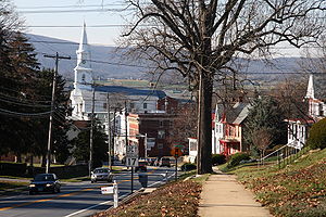
US 40 Alternate enters the town of Boonsboro and its name changes to Main Street at its intersection with MD 68
(Lappans Road). The highway meets the south end of MD 66
(Maple Avenue) next to the Bowman House
and the east end of MD 34
(Potomac Street) in the center of town. US 40 Alternate leaves the town of Boonsboro at its intersection with MD 67
(Rohrersville Road). The alternate routes continues southeast as Boonsboro Pike and starts to ascend South Mountain. At the summit, known as Turner's Gap
, US 40 Alternate intersects Washington Monument Road, which leads north to Washington Monument State Park, and passes the Dahlgren Chapel
and the Old South Mountain Inn.
 US 40 Alternate's name changes to Old National Pike as it intersects the Appalachian Trail
and begins its curvaceous descent of South Mountain into the Middletown Valley
. In the western part of the valley, the highway passes the Henry Shoemaker Farmhouse
and intersects Mount Tabor Road, which parallels South Mountain north past the historic Daniel Sheffer Farm
and Routzahn-Miller Farmstead
. In Spoolsville
, US 40 Alternate crosses Catoctin Creek
and meets Old Hagerstown Road, which passes the Bowlus Mill House
. The alternate route's name becomes Main Street as it heads east through Middletown. US 40 Alternate passes the Stonebraker and Harbaugh-Shafer Building
and intersects MD 17
(Church Street) within the Middletown Historic District. The highway passes through the Airview Historic District
before leaving the town limits.
East of Middletown, US 40 Alternate passes through a suburban area then begins to ascend Catoctin Mountain, which is locally known as Braddock Mountain. The highway gains a climbing lane eastbound to the top of the mountain, which contains the community of Braddock Heights
. US 40 Alternate is a four-lane road, with westbound climbing lane and center turn lane, as the highway descends the mountain to a partial interchange with I-70. The alternate route temporarily expands to a four-lane divided highway through the interchange, which has ramps to and from the direction of Frederick. East of I-70, US 40 Alternate reduces to two lanes and passes the Highland Lodge
. The alternate route reaches its eastern terminus at a partial intersection with US 40 (Patrick Street) at the western edge of Frederick and the Frederick Golden Mile, a heavily commercialized area east to US 15
(Frederick Freeway). There is no direct access from eastbound US 40 Alternate to westbound US 40 or from eastbound US 40 to the westbound alternate route; those movements are made by using Old Camp Road.
, Lancaster
, and Hanover
with Winchester, Virginia
by way of what is now Taneytown
, Frederick, Boonesboro, and Williamsport
. The portion of the Monocacy Road from Frederick to Williamsport was used by the Braddock Expedition
on its way from Alexandria
to Cumberland to commence its ill-fated assault on Fort Duquesne
. Following the founding of Hagerstown in 1762, a road was laid out north from Boonsboro to connect the new town with the eastern part of the colony. While the Monocacy Road as a whole was disused by 1794, the portion followed by US 40 Alternate remained an important connection between Baltimore and Western Maryland
.
The Baltimore and Fredericktown Turnpike Company was chartered in 1805 to build a road along the 62 miles (99.8 km) path from Baltimore to Boonesboro. This turnpike was the first step in connecting Baltimore with Cumberland, the eastern terminus of the just-commenced National Road. By 1808, the turnpike had been completed west 20 miles (32.2 km) from Baltimore and another 17 miles (27.4 km) was under construction. The Baltimore and Fredericktown Turnpike was completed in 1812. That same year, keen for an improved road to fully extend between Baltimore and Cumberland, the Maryland General Assembly conscripted the state's banks to fund turnpike companies to complete the gap between Boonsboro and Cumberland with the benefit of having their charters extended from 1816 to 1835. The banks opposed this measure but reluctantly bankrolled the construction of a road from Conocheague Creek to Cumberland between 1816 and 1818 and from Hagerstown to Conococheague Creek in 1818 and 1819. The Maryland General Assembly used their powers again in 1821, agreeing to extend the banks' charters to 1845 if they would fund a turnpike in the gap between Boonsboro and Hagerstown. When the National Turnpike was completed in 1823, it became the first macadam road constructed in the United States.
The Baltimore and Fredericktown and National turnpikes remained in operation in 1898 and in 1909 when the Maryland State Highway Administration (MDSRC) designated the road between Frederick and Hagerstown for improvement as one of the original state roads. The commission's first task was to acquire the necessary right-of-way by purchasing the two turnpikes in 1911. MDSRC reconstructed the road between Frederick and Hagerstown with a 14 feet (4.3 m) wide macadam surface Frederick to Middletown and from South Mountain to Boonsboro in 1913. The state road was built from Middletown to South Mountain and from Boonsboro to Hagerstown in 1914. The portion of the highway within Boonsboro was constructed in 1915. The last portion of the Frederick–Hagerstown state road to be constructed was within Funkstown, where the highway was surfaced with concrete by 1919. The highway was designated part of US 40 in 1927.
Around 1926, US 40 received its first improvement when concrete shoulders were added to expand the roadway from 14 metres (45.9 ft) to 20 feet (6.1 m) in width. By 1934, MDSRC recommended widening the highway to 30 feet (9.1 m) from 5 miles (8 km) west of Frederick to 5 miles (8 km) east of Hagerstown. Ultimately, the commission decided to construct a new highway between the two cities that would shorten the distance by 1.25 miles (2 km) and bypass the sharp curves and limited sight distances of the old road. Grading and drainage work on the new highway began in 1936 and was completed in 1938 for the first roadway of what would ultimately become a divided highway. The first 20 feet (6.1 m) wide concrete roadway was constructed from downtown Hagerstown southeast to near Beaver Creek Road in 1938. Surfacing of the remainder of the relocated National Pike was delayed by World War II; construction resumed in 1946 and the new highway opened in 1948.
The relocated National Pike was originally designated US 40 Alternate; the old and new roads switched to their present designations in 1952. Despite the construction of a new highway, improvements continued on the original road. Trolley tracks of the Hagerstown and Frederick Railway
were removed from the highway in Funkstown and the street was resurfaced in 1940. Hill climbing lanes were added for a length of 800 to 1000 ft (243.8 to 304.8 m) on both sides of Braddock Mountain and South Mountain around 1942. The highway between Funkstown and Boonsboro had curves modified and was widened and resurfaced in 1949. US 40 Alternate from US 40 in Frederick west to Braddock Mountain underwent the same type of work in 1951 and 1952.
!County
!Location
!Mile
!Destinations
!Notes
|-
|rowspan=8|Washington
|rowspan=2|Hagerstown
|0.00
|Baltimore Street west / Potomac Street south to
|Western terminus; Potomac Street is one-way southbound
|-
|0.24
|Baltimore Street east / Mulberry Avenue
|Five-way intersection; US 40 Alternate turns southeast onto Frederick Street
|-
|rowspan=2|Funkstown
|2.16
|Westside Street south / Baltimore Street west
|US 40 Alternate turns east onto Baltimore Street
|-
|2.48
|Baltimore Street east / Edgewood Drive north
|US 40 Alternate turns south onto Frederick Road
|-
|rowspan=4|Boonsboro
|9.16
|
|
|-
|9.75
|
|
|-
|10.21
|
|
|-
|10.95
| – Harpers Ferry
|
|-
|rowspan=3|Frederick
|rowspan=1|Middletown
|17.77
|
|
|-
|rowspan=2|Frederick
|21.60
|, Washington
|I-70 Exit 49; westbound exit from and eastbound entrance to I-70
|-
|22.97
|
|Eastern terminus; westbound exit from and eastbound entrance to US 40
U.S. Route 40 in Maryland
U.S. Route 40 in the U.S. state of Maryland runs from western Maryland to Cecil County in the state's northeastern corner. With a total length of over , it is the longest numbered highway in Maryland. Almost half of the road overlaps with Interstate 68 or Interstate 70, while the old alignment...
in the U.S. state of Maryland
Maryland
Maryland is a U.S. state located in the Mid Atlantic region of the United States, bordering Virginia, West Virginia, and the District of Columbia to its south and west; Pennsylvania to its north; and Delaware to its east...
. The highway runs 22.97 miles (37 km) from Potomac Street in Hagerstown
Hagerstown, Maryland
Hagerstown is a city in northwestern Maryland, United States. It is the county seat of Washington County, and, by many definitions, the largest city in a region known as Western Maryland. The population of Hagerstown city proper at the 2010 census was 39,662, and the population of the...
east to US 40 in Frederick
Frederick, Maryland
Frederick is a city in north-central Maryland. It is the county seat of Frederick County, the largest county by area in the state of Maryland. Frederick is an outlying community of the Washington-Arlington-Alexandria, DC-VA-MD-WV Metropolitan Statistical Area, which is part of a greater...
. US 40 Alternate parallels US 40 to the south through eastern Washington County
Washington County, Maryland
Washington County is a county located in the western part of the U.S. state of Maryland, bordering southern Pennsylvania to the north, northern Virginia to the south, and the Eastern Panhandle of West Virginia to the south and west. As of the 2010 Census, its population is 147,430...
and western Frederick County
Frederick County, Maryland
Frederick County is a county located in the western part of the U.S. state of Maryland, bordering the southern border of Pennsylvania and the northeastern border of Virginia. As of the 2010 Census, the population was 233,385....
. The alternate route connects Hagerstown and Frederick with Funkstown
Funkstown, Maryland
Funkstown is a town in Washington County, Maryland, United States. The population was 983 at the 2000 census.-History:Originally were sold to Henry Funk by Frederick Calvert in 1754 and settled as Jerusalem.Funck’s Jerusalem Town...
, Boonsboro
Boonsboro, Maryland
Boonsboro is a town in Washington County, Maryland, United States, located at the foot of South Mountain. It nearly borders Frederick County and is proximate to the Antietam National Battlefield...
, Middletown
Middletown, Maryland
Middletown is a town in Frederick County, Maryland, United States. The population was 2,668 at the 2000 census. Middletown is a small, rural community steeped in American history...
, and Braddock Heights
Braddock Heights, Maryland
Braddock Heights is a census-designated place in Frederick County, Maryland, United States. The population was 4,627 at the 2000 census. Braddock Heights is part of the Middletown, Maryland School District...
.
US 40 Alternate is the old alignment of US 40. The highway's path was blazed in the mid-18th century to connect the Hagerstown Valley
Hagerstown Valley
Hagerstown Valley is located in Maryland in the United States. It is part of the Great Appalachian Valley, which continues northward as Cumberland Valley in Pennsylvania, and southward as Shenandoah Valley in West Virginia and Virginia....
and Shenandoah Valley
Shenandoah Valley
The Shenandoah Valley is both a geographic valley and cultural region of western Virginia and West Virginia in the United States. The valley is bounded to the east by the Blue Ridge Mountains, to the west by the eastern front of the Ridge-and-Valley Appalachians , to the north by the Potomac River...
with eastern Pennsylvania
Pennsylvania
The Commonwealth of Pennsylvania is a U.S. state that is located in the Northeastern and Mid-Atlantic regions of the United States. The state borders Delaware and Maryland to the south, West Virginia to the southwest, Ohio to the west, New York and Ontario, Canada, to the north, and New Jersey to...
and central Maryland. In the early 19th century, US 40 Alternate's path was improved as part of a series of turnpikes to connect Baltimore with the eastern terminus of the National Road
National Road
The National Road or Cumberland Road was the first major improved highway in the United States to be built by the federal government. Construction began heading west in 1811 at Cumberland, Maryland, on the Potomac River. It crossed the Allegheny Mountains and southwestern Pennsylvania, reaching...
in Cumberland
Cumberland, Maryland
Cumberland is a city in the far western, Appalachian portion of Maryland, United States. It is the county seat of Allegany County, and the primary city of the Cumberland, MD-WV Metropolitan Statistical Area. At the 2010 census, the city had a population of 20,859, and the metropolitan area had a...
. The highway was improved as one of the original state roads in the early 1910s and designated US 40 in the late 1920s. Construction on a relocated US 40 between Hagerstown and Frederick with improved crossings of Catoctin Mountain
Catoctin Mountain
Catoctin Mountain, along with the geologically associated Bull Run Mountains, comprises the easternmost mountain ridge of the Blue Ridge Mountains, which are in turn a part of the Appalachian Mountains range...
and South Mountain
South Mountain (Maryland and Pennsylvania)
South Mountain is the northern extension of the Blue Ridge Mountain range in Maryland and Pennsylvania. From the Potomac River near Knoxville, Maryland in the south, to Dillsburg, Pennsylvania in the north, the long range separates the Hagerstown and Cumberland valleys from the Piedmont regions of...
began in the mid 1930s; the new highway was completed in the late 1940s. US 40 Alternate was assigned to the old route of US 40 in the early 1950s.
Washington County
US 40 Alternate begins at an intersection with Potomac Street in Hagerstown. Potomac Street, which is one-way southbound, comes south from downtown Hagerstown, where the street intersects the US 40 one-way pairOne-way pair
A one-way pair, one-way couple, or just couplet is a pair of parallel, usually one-way streets that carry opposite directions of a signed route or major traffic flow, or sometimes opposite directions of a bus or streetcar route....
(Washington Street eastbound and Franklin Street westbound). Potomac Street continues south toward Sharpsburg
Sharpsburg, Maryland
Sharpsburg is a town in Washington County, Maryland, United States, approximately south of Hagerstown. The population was 691 at the 2000 census....
, becoming MD 65
Maryland Route 65
Maryland Route 65 is a state highway in the U.S. state of Maryland. Known for most of its length as Sharpsburg Pike, the state highway runs from MD 34 in Sharpsburg north to the southern end of Hagerstown, where the highway continues north as Potomac Street toward the downtown area...
near the south city limit of Hagerstown. Baltimore Street continues west toward Hagerstown City Park
Hagerstown City Park
Hagerstown City Park is a public urban park just southwest of the central business district of Hagerstown, Maryland, United States. The park is located at the junction of Virginia Avenue, Key Street, Walnut Street, Prospect Street, and Memorial Boulevard....
. US 40 Alternate heads east as two-lane Baltimore Street through the Hagerstown Historic District
Hagerstown Historic District
Hagerstown Historic District is a national historic district at Hagerstown, Washington County, Maryland, United States. The district contains the downtown commercial and governmental center as well as several surrounding urban residential neighborhoods and industrial areas...
. After intersecting one-way northbound Locust Street, the municipally-maintained alternate route turns southeast onto Frederick Street at a five-way junction that also includes north–south Mulberry Street. South of downtown, US 40 Alternate intersects Memorial Boulevard, which heads east past Municipal Stadium
Municipal Stadium (Hagerstown)
Municipal Stadium is a stadium in Hagerstown, Maryland, United States. It is primarily used for baseball, and is the home field of the Hagerstown Suns minor league baseball team. It was built in 1931 in a short time period of six weeks. It holds 4,600 people which is the smallest capacity in the...
, home of the minor league Hagerstown Suns
Hagerstown Suns
The Hagerstown Suns are a Minor League Baseball team based in Hagerstown, Maryland, United States. They play in Municipal Stadium, which was opened in 1930 and seats 4,600 fans....
. The highway meets a CSX
CSX Transportation
CSX Transportation operates a Class I railroad in the United States known as the CSX Railroad. It is the main subsidiary of the CSX Corporation. The company is headquartered in Jacksonville, Florida, and owns approximately 21,000 route miles...
rail spur at grade while passing through an industrial area that extends to the southern city limits of Hagerstown at Kenly Avenue.
US 40 Alternate continues southeast as a state-maintained highway that passes the historic home Garden Hill
Garden Hill
Garden Hill, also known as the Robert Cushen farmstead, is a historic home located at Hagerstown, Washington County, Maryland, United States. It was built about 1865, and is a two-story five-bay brick dwelling with a formal facade and a central entrance...
and crosses Antietam Creek
Antietam Creek
Antietam Creek is a tributary of the Potomac River located in south central Pennsylvania and western Maryland in the United States, a region known as the Hagerstown Valley...
into Funkstown, where the highway's name changes to Westside Avenue. Within the Funkstown Historic District
Funkstown Historic District
Funkstown Historic District is a national historic district at Funkstown, Washington County, Maryland, United States. The district includes 217 contributing buildings, one contributing structure, and three contributing sites. The National Road forms Funkstown's main street and shaped in a...
, the alternate route turns east onto Baltimore Street, then southeast onto Frederick Street. At the southern town limits of Funkstown, US 40 Alternate becomes Boonsboro Pike, which passes through farmland as it parallels Antietam Creek. The highway passes under I-70
Interstate 70 in Maryland
Interstate 70 is a part of the Interstate Highway System that runs from Cove Fort, Utah to Baltimore, Maryland. In Maryland, the Interstate Highway runs from the Pennsylvania state line in Hancock east to the Interstate's eastern terminus near its junction with I-695 at a park and ride in...
(Eisenhower Memorial Highway) with no access and intersects Poffenberger Road, which leads west to the historic home Valentia
Valentia (Hagerstown, Maryland)
Valentia is a historic home located at Hagerstown, Washington County, Maryland, United States. It is a large -story L-shaped stone farmhouse, facing south overlooking Antietam Creek. The house features a flat-roofed, one-story porch covers the south door and flanking windows and is supported by...
. The highway veers away from Antietam Creek, passes through the hamlet of Benevola
Benevola, Maryland
Benevola is an unincorporated community in Washington County, Maryland, United States.-References:...
, and traverses Landis Spring Branch and Beaver Creek on its way to Boonsboro.
US 40 Alternate enters the town of Boonsboro and its name changes to Main Street at its intersection with MD 68
Maryland Route 68
Maryland Route 68 is a state highway in the U.S. state of Maryland. The state highway runs from U.S. Route 40 in Clear Spring east to US 40 Alternate in Boonsboro. MD 68 crosses central Washington County to the south of Hagerstown, connecting Clear Spring and Boonsboro with Williamsport, where...
(Lappans Road). The highway meets the south end of MD 66
Maryland Route 66
Maryland Route 66 is a state highway in the U.S. state of Maryland. Known for most of its length as Mapleville Road, the state highway runs from U.S. Route 40 Alternate in Boonsboro north to MD 64 near Smithsburg...
(Maple Avenue) next to the Bowman House
Bowman House (Boonsboro, Maryland)
The Bowman House is a log house in Boonsboro, Maryland, United States, typical of those built in the area in the early 19th century. It and its immediate grounds housed the "Boonsboro Pottery" from 1868, owned by John E. Bowman. The pottery closed by 1908, succumbing to mass-produced materials...
and the east end of MD 34
Maryland Route 34
Maryland Route 34 is a state highway in the U.S. state of Maryland. Known for most of its length as Shepherdstown Pike, the state highway begins at the West Virginia state line at the Potomac River, where the highway continues south as West Virginia Route 480 through Shepherdstown. The state...
(Potomac Street) in the center of town. US 40 Alternate leaves the town of Boonsboro at its intersection with MD 67
Maryland Route 67
Maryland Route 67 is a state highway in the U.S. state of Maryland. Known as Rohrersville Road, the state highway runs from U.S. Route 340 in Weverton north to US 40 Alternate in Boonsboro. MD 67 parallels the western flank of South Mountain in southeastern Washington County, connecting...
(Rohrersville Road). The alternate routes continues southeast as Boonsboro Pike and starts to ascend South Mountain. At the summit, known as Turner's Gap
Turner's Gap
Turner's Gap is a wind gap in the South Mountain Range of the Blue Ridge Mountains, located in Frederick County and Washington County, Maryland. The gap is traversed by U.S. Route 40 Alt, the Old National Pike. The Appalachian Trail also crosses the gap....
, US 40 Alternate intersects Washington Monument Road, which leads north to Washington Monument State Park, and passes the Dahlgren Chapel
Dahlgren Chapel (Maryland)
Dahlgren Chapel is located at the summit of Turner's Gap in western Maryland between Middletown and Boonsboro. The Gothic revival stone chapel was built in 1881 and consecrated as the Chapel of St. Joseph of the Sacred Heart of Jesus...
and the Old South Mountain Inn.
Frederick County
Appalachian Trail
The Appalachian National Scenic Trail, generally known as the Appalachian Trail or simply the AT, is a marked hiking trail in the eastern United States extending between Springer Mountain in Georgia and Mount Katahdin in Maine. It is approximately long...
and begins its curvaceous descent of South Mountain into the Middletown Valley
Middletown Valley
Middletown Valley, also historically known as Catoctin Valley, is a valley in western Frederick County in the state of Maryland.-Geography:...
. In the western part of the valley, the highway passes the Henry Shoemaker Farmhouse
Henry Shoemaker Farmhouse
The Henry Shoemaker Farmhouse is a circa 1810 Federal style farmhouse which was involved in the Battle of South Mountain in 1862. Located near the eastern end of Turner's Gap, the house was the center of a Union encampment and served as a field hospital....
and intersects Mount Tabor Road, which parallels South Mountain north past the historic Daniel Sheffer Farm
Daniel Sheffer Farm
The Daniel Sheffer Farm is a historic home and farm complex located at Middletown, Frederick County, Maryland, United States. It is dominated by the two story brick main house, which was constructed between 1840 and 1850...
and Routzahn-Miller Farmstead
Routzahn-Miller Farmstead
The Routzahn—Miller Farmstead is a historic home and farm complex located at Middletown, Frederick County, Maryland, United States. It consists of a 1825 Federal style-influenced brick house and smokehouse, both built about 1825, a later frame out-kitchen / washhouse, a standard Pennsylvania barn,...
. In Spoolsville
Spoolsville, Maryland
Spoolsville is an unincorporated community in Frederick County, Maryland, United States. Bowlus Mill House was listed on the National Register of Historic Places in 1996.-References:...
, US 40 Alternate crosses Catoctin Creek
Catoctin Creek (Maryland)
Catoctin Creek is a tributary of the Potomac River in Frederick County, Maryland, USA. Its source is formed in the Myersville, MD area and flows directly south for the entire length of the stream. Catoctin Creek enters the Potomac River east of Brunswick. The stream flows through Catoctin Creek...
and meets Old Hagerstown Road, which passes the Bowlus Mill House
Bowlus Mill House
The Bowlus Mill House is a historic home and farm complex located at Spoolsville, Frederick County, Maryland, United States. It consists of the house built of narrow courses of flat cut stones, a frame bank barn on a stone foundation, and a small frame shed...
. The alternate route's name becomes Main Street as it heads east through Middletown. US 40 Alternate passes the Stonebraker and Harbaugh-Shafer Building
Stonebraker and Harbaugh-Shafer Building
The Stonebraker and Harbaugh, Shafer Building in Middletown, Maryland was built circa 1830 with a residential section to the east and a commercial section to the west. The Federal style building incorporates Greek Revival detailing in the interior. It is included in the Middletown Historic...
and intersects MD 17
Maryland Route 17
Maryland Route 17 is a state highway in the U.S. state of Maryland. The state highway begins at the Virginia state line at the Potomac River in Brunswick, where the highway continues south as Virginia State Route 287 . MD 17 runs north from the Brunswick Bridge to the Frederick–Washington...
(Church Street) within the Middletown Historic District. The highway passes through the Airview Historic District
Airview Historic District
The Airview Historic District is a district of 12 houses built between 1896 and 1930 on each side of East Main Street in Middletown, Maryland. The district was developed to take advantage of the Hagerstown and Frederick Railway, which paralleled what was then known as the National Pike, and is an...
before leaving the town limits.
East of Middletown, US 40 Alternate passes through a suburban area then begins to ascend Catoctin Mountain, which is locally known as Braddock Mountain. The highway gains a climbing lane eastbound to the top of the mountain, which contains the community of Braddock Heights
Braddock Heights, Maryland
Braddock Heights is a census-designated place in Frederick County, Maryland, United States. The population was 4,627 at the 2000 census. Braddock Heights is part of the Middletown, Maryland School District...
. US 40 Alternate is a four-lane road, with westbound climbing lane and center turn lane, as the highway descends the mountain to a partial interchange with I-70. The alternate route temporarily expands to a four-lane divided highway through the interchange, which has ramps to and from the direction of Frederick. East of I-70, US 40 Alternate reduces to two lanes and passes the Highland Lodge
Highland Lodge
The Highland Lodge, also known as Pequea, is a historic home and resort building complex located at Frederick, Frederick County, Maryland, United States. It consists of a large Victorian period frame house centered at the end of a circular driveway, and its complement of outbuildings...
. The alternate route reaches its eastern terminus at a partial intersection with US 40 (Patrick Street) at the western edge of Frederick and the Frederick Golden Mile, a heavily commercialized area east to US 15
U.S. Route 15 in Maryland
U.S. Route 15 is a part of the U.S. Highway System that runs from Walterboro, South Carolina to Painted Post, New York. In Maryland, the highway runs from the Virginia state line at the Potomac River in Point of Rocks north to the Pennsylvania state line near Emmitsburg. US 15 is...
(Frederick Freeway). There is no direct access from eastbound US 40 Alternate to westbound US 40 or from eastbound US 40 to the westbound alternate route; those movements are made by using Old Camp Road.
History
The portion of US 40 Alternate between Frederick and Boonsboro roughly follows the Monocacy Road, a pack-horse trail blazed by settlers from Pennsylvania around 1730. The trail connected PhiladelphiaPhiladelphia, Pennsylvania
Philadelphia is the largest city in the Commonwealth of Pennsylvania and the county seat of Philadelphia County, with which it is coterminous. The city is located in the Northeastern United States along the Delaware and Schuylkill rivers. It is the fifth-most-populous city in the United States,...
, Lancaster
Lancaster, Pennsylvania
Lancaster is a city in the south-central part of the Commonwealth of Pennsylvania. It is the county seat of Lancaster County and one of the older inland cities in the United States, . With a population of 59,322, it ranks eighth in population among Pennsylvania's cities...
, and Hanover
Hanover, Pennsylvania
Hanover is a borough in York County, Pennsylvania, southwest of York and north-northwest of Baltimore, Maryland.The town is situated in a productive agricultural region. The population was 15,289 at the 2010 census. The borough is served by a 717 area code and the Zip Codes of 17331-34...
with Winchester, Virginia
Winchester, Virginia
Winchester is an independent city located in the northwestern portion of the Commonwealth of Virginia in the USA. The city's population was 26,203 according to the 2010 Census...
by way of what is now Taneytown
Taneytown, Maryland
Taneytown is a city in Carroll County, Maryland, United States. The population was 5,128 at the 2000 census. was founded in 1754. Of the town George Washington once wrote "Tan-nee town is but a small place with only the Street through wch. the road passes, built on...
, Frederick, Boonesboro, and Williamsport
Williamsport, Maryland
Williamsport is a town in Washington County, Maryland, United States. The population was 1,868 at the 2000 census and 2,278 as of July 2008.-Geography: Williamsport is located at ....
. The portion of the Monocacy Road from Frederick to Williamsport was used by the Braddock Expedition
Braddock expedition
The Braddock expedition, also called Braddock's campaign or, more commonly, Braddock's Defeat, was a failed British military expedition which attempted to capture the French Fort Duquesne in the summer of 1755 during the French and Indian War. It was defeated at the Battle of the Monongahela on...
on its way from Alexandria
Alexandria, Virginia
Alexandria is an independent city in the Commonwealth of Virginia. As of 2009, the city had a total population of 139,966. Located along the Western bank of the Potomac River, Alexandria is approximately six miles south of downtown Washington, D.C.Like the rest of northern Virginia, as well as...
to Cumberland to commence its ill-fated assault on Fort Duquesne
Battle of Fort Duquesne
The Battle of Fort Duquesne was a British assault on the eponymous French fort that was repulsed with heavy losses on 14 September 1758, during the French and Indian War....
. Following the founding of Hagerstown in 1762, a road was laid out north from Boonsboro to connect the new town with the eastern part of the colony. While the Monocacy Road as a whole was disused by 1794, the portion followed by US 40 Alternate remained an important connection between Baltimore and Western Maryland
Western Maryland
Western Maryland is the portion of the U.S. state of Maryland that consists of Frederick, Washington, Allegany, and Garrett counties. The region is bounded by the Mason-Dixon line to the north, Preston County, West Virginia to the west, and the Potomac River to the south. There is dispute over the...
.
The Baltimore and Fredericktown Turnpike Company was chartered in 1805 to build a road along the 62 miles (99.8 km) path from Baltimore to Boonesboro. This turnpike was the first step in connecting Baltimore with Cumberland, the eastern terminus of the just-commenced National Road. By 1808, the turnpike had been completed west 20 miles (32.2 km) from Baltimore and another 17 miles (27.4 km) was under construction. The Baltimore and Fredericktown Turnpike was completed in 1812. That same year, keen for an improved road to fully extend between Baltimore and Cumberland, the Maryland General Assembly conscripted the state's banks to fund turnpike companies to complete the gap between Boonsboro and Cumberland with the benefit of having their charters extended from 1816 to 1835. The banks opposed this measure but reluctantly bankrolled the construction of a road from Conocheague Creek to Cumberland between 1816 and 1818 and from Hagerstown to Conococheague Creek in 1818 and 1819. The Maryland General Assembly used their powers again in 1821, agreeing to extend the banks' charters to 1845 if they would fund a turnpike in the gap between Boonsboro and Hagerstown. When the National Turnpike was completed in 1823, it became the first macadam road constructed in the United States.
The Baltimore and Fredericktown and National turnpikes remained in operation in 1898 and in 1909 when the Maryland State Highway Administration (MDSRC) designated the road between Frederick and Hagerstown for improvement as one of the original state roads. The commission's first task was to acquire the necessary right-of-way by purchasing the two turnpikes in 1911. MDSRC reconstructed the road between Frederick and Hagerstown with a 14 feet (4.3 m) wide macadam surface Frederick to Middletown and from South Mountain to Boonsboro in 1913. The state road was built from Middletown to South Mountain and from Boonsboro to Hagerstown in 1914. The portion of the highway within Boonsboro was constructed in 1915. The last portion of the Frederick–Hagerstown state road to be constructed was within Funkstown, where the highway was surfaced with concrete by 1919. The highway was designated part of US 40 in 1927.
Around 1926, US 40 received its first improvement when concrete shoulders were added to expand the roadway from 14 metres (45.9 ft) to 20 feet (6.1 m) in width. By 1934, MDSRC recommended widening the highway to 30 feet (9.1 m) from 5 miles (8 km) west of Frederick to 5 miles (8 km) east of Hagerstown. Ultimately, the commission decided to construct a new highway between the two cities that would shorten the distance by 1.25 miles (2 km) and bypass the sharp curves and limited sight distances of the old road. Grading and drainage work on the new highway began in 1936 and was completed in 1938 for the first roadway of what would ultimately become a divided highway. The first 20 feet (6.1 m) wide concrete roadway was constructed from downtown Hagerstown southeast to near Beaver Creek Road in 1938. Surfacing of the remainder of the relocated National Pike was delayed by World War II; construction resumed in 1946 and the new highway opened in 1948.
The relocated National Pike was originally designated US 40 Alternate; the old and new roads switched to their present designations in 1952. Despite the construction of a new highway, improvements continued on the original road. Trolley tracks of the Hagerstown and Frederick Railway
Hagerstown and Frederick Railway
The Hagerstown & Frederick Railway, now defunct, was an American railroad of central Maryland built in the 19th and 20th centuries.-Early development:...
were removed from the highway in Funkstown and the street was resurfaced in 1940. Hill climbing lanes were added for a length of 800 to 1000 ft (243.8 to 304.8 m) on both sides of Braddock Mountain and South Mountain around 1942. The highway between Funkstown and Boonsboro had curves modified and was widened and resurfaced in 1949. US 40 Alternate from US 40 in Frederick west to Braddock Mountain underwent the same type of work in 1951 and 1952.
Junction list
{| class=wikitable!County
!Location
!Mile
!Destinations
!Notes
|-
|rowspan=8|Washington
Washington County, Maryland
Washington County is a county located in the western part of the U.S. state of Maryland, bordering southern Pennsylvania to the north, northern Virginia to the south, and the Eastern Panhandle of West Virginia to the south and west. As of the 2010 Census, its population is 147,430...
|rowspan=2|Hagerstown
Hagerstown, Maryland
Hagerstown is a city in northwestern Maryland, United States. It is the county seat of Washington County, and, by many definitions, the largest city in a region known as Western Maryland. The population of Hagerstown city proper at the 2010 census was 39,662, and the population of the...
|0.00
|Baltimore Street west / Potomac Street south to
|Western terminus; Potomac Street is one-way southbound
|-
|0.24
|Baltimore Street east / Mulberry Avenue
|Five-way intersection; US 40 Alternate turns southeast onto Frederick Street
|-
|rowspan=2|Funkstown
Funkstown, Maryland
Funkstown is a town in Washington County, Maryland, United States. The population was 983 at the 2000 census.-History:Originally were sold to Henry Funk by Frederick Calvert in 1754 and settled as Jerusalem.Funck’s Jerusalem Town...
|2.16
|Westside Street south / Baltimore Street west
|US 40 Alternate turns east onto Baltimore Street
|-
|2.48
|Baltimore Street east / Edgewood Drive north
|US 40 Alternate turns south onto Frederick Road
|-
|rowspan=4|Boonsboro
Boonsboro, Maryland
Boonsboro is a town in Washington County, Maryland, United States, located at the foot of South Mountain. It nearly borders Frederick County and is proximate to the Antietam National Battlefield...
|9.16
|
|
|-
|9.75
|
|
|-
|10.21
|
|
|-
|10.95
| – Harpers Ferry
Harpers Ferry, West Virginia
Harpers Ferry is a historic town in Jefferson County, West Virginia, United States. In many books the town is called "Harper's Ferry" with an apostrophe....
|
|-
|rowspan=3|Frederick
Frederick County, Maryland
Frederick County is a county located in the western part of the U.S. state of Maryland, bordering the southern border of Pennsylvania and the northeastern border of Virginia. As of the 2010 Census, the population was 233,385....
|rowspan=1|Middletown
Middletown, Maryland
Middletown is a town in Frederick County, Maryland, United States. The population was 2,668 at the 2000 census. Middletown is a small, rural community steeped in American history...
|17.77
|
|
|-
|rowspan=2|Frederick
Frederick, Maryland
Frederick is a city in north-central Maryland. It is the county seat of Frederick County, the largest county by area in the state of Maryland. Frederick is an outlying community of the Washington-Arlington-Alexandria, DC-VA-MD-WV Metropolitan Statistical Area, which is part of a greater...
|21.60
|, Washington
Washington, D.C.
Washington, D.C., formally the District of Columbia and commonly referred to as Washington, "the District", or simply D.C., is the capital of the United States. On July 16, 1790, the United States Congress approved the creation of a permanent national capital as permitted by the U.S. Constitution....
|I-70 Exit 49; westbound exit from and eastbound entrance to I-70
|-
|22.97
|
|Eastern terminus; westbound exit from and eastbound entrance to US 40