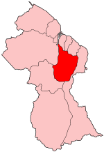
Upper Demerara-Berbice
Encyclopedia

Guyana
Guyana , officially the Co-operative Republic of Guyana, previously the colony of British Guiana, is a sovereign state on the northern coast of South America that is culturally part of the Anglophone Caribbean. Guyana was a former colony of the Dutch and of the British...
, bordering the regions of Essequibo Islands-West Demerara
Essequibo Islands-West Demerara
Essequibo Islands-West Demerara is a region of Guyana, split in two by the Essequibo River. It is bordered by the Atlantic Ocean to the north, the region of Demerara-Mahaica to the east, the region of Upper Demerara-Berbice to the south and the regions ofIt contains the towns of Parika, Schoon Ord...
, Demerara-Mahaica
Demerara-Mahaica
Demerara-Mahaica is a region of Guyana, bordering the Atlantic Ocean to the north, the region of Mahaica-Berbice to the east, the region of Upper Demerara-Berbice to the south and the region of Essequibo Islands-West Demerara to the west....
and Mahaica-Berbice
Mahaica-Berbice
Mahaica-Berbice is a region of Guyana, bordering the Atlantic Ocean to the north, the region of East Berbice-Corentyne to the east, the region of Upper Demerara-Berbice to the south and the region of Demerara-Mahaica to the west....
to the north, the region of East Berbice-Corentyne
East Berbice-Corentyne
East Berbice-Corentyne is one of ten regions in Guyana covering the whole of the east of the country. It borders the Atlantic Ocean to the north, Suriname to the east, Brazil to the south and the regions of Mahaica-Berbice, Upper Demerara-Berbice, Potaro-Siparuni and Upper Takutu-Upper Essequibo...
to the east, and the regions of Potaro-Siparuni
Potaro-Siparuni
Potaro-Siparuni is a region in Guyana, bordering the region of Cuyuni-Mazaruni to the north, the regions of Upper Demerara-Berbice and East Berbice-Corentyne to the east, the region of Upper Takutu-Upper Essequibo to the south and Brazil to the west.The main towns in the region are Kangaruma,...
and Cuyuni-Mazaruni
Cuyuni-Mazaruni
Cuyuni-Mazaruni is a region of Esequiban Guyana, a territory in dispute by Guyana and Venezuela, bordering the regions of Barima-Waini, Essequibo Islands-West Demerara and Pomeroon-Supenaam to the north, the region of Upper Demerara-Berbice to the east, the region of Potaro-Siparuni and Brazil to...
to the west.
It contains Guyana's second largest city, Linden
Linden, Guyana
Linden is the second largest town in Guyana after Georgetown, and capital of the Upper Demerara-Berbice region, located at , altitude 48 metres . It was declared a town in 1970, and includes the communities of MacKenzie and Wismar. It lies on the Demerara River and has a population of roughly...
, with other towns including Ituni
Ituni
Ituni is a town in the interior of Guyana, at an altitude of 100 metres . Bauxite mining is the main industry....
, Kalkuni
Kalkuni
Kalkuni is a village in the southern state of Karnataka, India. It is located in the Malavalli taluk of Mandya district in Karnataka.-Demographics:As of 2001 India census, Kalkuni had a population of 8328 with 4342 males and 3986 females.-External links:...
, Kwakwani
Kwakwani
Kwakwani is a village on the Berbice River in the Upper Demerara-Berbice Region of Guyana, located at , altitude 44 Metres . Kwakwani is approximately 40 km south of Linden. Bauxite mining is the main industry....
, Kurupakari, Rockstone
Rockstone
Rockstone is a town on the right bank of the Essequibo River in the Upper Demerara-Berbice Region of Guyana, located at , altitude 6 Metres . Rockstone is approximately 26 km west of Linden and is linked by road....
and Takama.
Population
Upper Demerara-Berbice's population was 41,112 in 2002 (Official census).- 2002 : 41,112
- 1991 : 39,608
- 1980 : 38,641
Communities
(including name variants):- Attai
- Attai Village
- Bartica
- Christianburg
- Cockatara Village
- Ebini
- Ebini Downs
- GNS Kimbia
Kimbia is the very first training center to house the Guyana National Service. The Pioneer Corps was started in 1974, with the establishment of Kimbia Center on the Berbice River. Kimbia is located in the Ebini Area, very close to the Ebini Agriculture Station.
- Hitia
- Hittia Settlement
- Hururu
- ItuniItuniItuni is a town in the interior of Guyana, at an altitude of 100 metres . Bauxite mining is the main industry....
- Ituni Townsite
- Itoni Township
- KalkuniKalkuniKalkuni is a village in the southern state of Karnataka, India. It is located in the Malavalli taluk of Mandya district in Karnataka.-Demographics:As of 2001 India census, Kalkuni had a population of 8328 with 4342 males and 3986 females.-External links:...
- Kokatara Village
- Kumaka
- Coomacka
- Kurupakari
- KwakwaniKwakwaniKwakwani is a village on the Berbice River in the Upper Demerara-Berbice Region of Guyana, located at , altitude 44 Metres . Kwakwani is approximately 40 km south of Linden. Bauxite mining is the main industry....
- Lancaster
- LindenLinden, GuyanaLinden is the second largest town in Guyana after Georgetown, and capital of the Upper Demerara-Berbice region, located at , altitude 48 metres . It was declared a town in 1970, and includes the communities of MacKenzie and Wismar. It lies on the Demerara River and has a population of roughly...
- Mackenzie
- McKenzie
- Malali
- Masabona
- Noitgedacht
- Paradise
- Pubu
- RockstoneRockstoneRockstone is a town on the right bank of the Essequibo River in the Upper Demerara-Berbice Region of Guyana, located at , altitude 6 Metres . Rockstone is approximately 26 km west of Linden and is linked by road....
- Sand Hills
- Takama
- Tacama
- Takama Battle School
- Urisirima
- Watuka
- Watooka Village
- Wiribisirikanali
- Wismar
- Wisemar
- Zion
- Sion

