Vaalserberg
Encyclopedia
The Vaalserberg is a hill 322.7 metres (1,059 ft) in height and the highest point in the European part of the Netherlands. The Vaalserberg is located in the province
of Limburg
, at the south-easternmost edge of the country
in the municipality
of Vaals
, near the eponym
ous town
, some three kilometres west of Aachen
.
Before 10 October 2010, the Vaalserberg was the highest point in the Netherlands, until upon the dissolution of the Netherlands Antilles when Mount Scenery
on Saba (the highest point in the Kingdom of the Netherlands
) became part of the Netherlands.

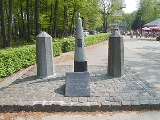
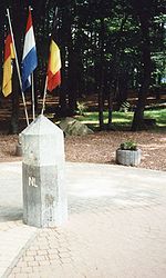
between Germany, Belgium and the Netherlands and its summit
is therefore referred to as Drielandenpunt ("Three-Country Point") in Dutch, or Dreiländereck ("Three-Country Corner") in German, or Trois Frontières ("Three Borders") in French.
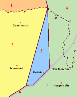
Between 1830 and 1919, the summit briefly was a quadripoint
, bordering also Neutral Moresnet.
 The current Belgian-German-border is not the same as the former eastern border of Moresnet with Prussia
; it lies a little more to the east. Therefore, 5 different borders came together in this point, however never more than 4 at the same time - except possibly for the period 1917-1920, where the border situation was not clear and not undisputed.
This border intersection has made the Vaalserberg a well-known tourist attraction in the Netherlands with a tower
on the Belgian side offering a grand panorama
of the surrounding landscape
. This tidy and urbanised development stands in marked contrast to the rough cinder
parking area that makes up the Belgium sector and the wooded nature reserve
on the German side.
and is climbed halfway through the race. The climb is named in the roadbook of the Gold Race as 'Drielandenpunt' and is follwed by the Gemmenich climb.
Province
A province is a territorial unit, almost always an administrative division, within a country or state.-Etymology:The English word "province" is attested since about 1330 and derives from the 13th-century Old French "province," which itself comes from the Latin word "provincia," which referred to...
of Limburg
Limburg (Netherlands)
Limburg is the southernmost of the twelve provinces of the Netherlands. It is located in the southeastern part of the country and bordered by the province of Gelderland to the north, Germany to the east, Belgium to the south and part of the west, andthe Dutch province of North Brabant partly to...
, at the south-easternmost edge of the country
Country
A country is a region legally identified as a distinct entity in political geography. A country may be an independent sovereign state or one that is occupied by another state, as a non-sovereign or formerly sovereign political division, or a geographic region associated with a previously...
in the municipality
Municipality
A municipality is essentially an urban administrative division having corporate status and usually powers of self-government. It can also be used to mean the governing body of a municipality. A municipality is a general-purpose administrative subdivision, as opposed to a special-purpose district...
of Vaals
Vaals
Vaals is a town in the extreme southeastern part of the Dutch province of Limburg, which in its turn finds itself in the southeastern part of the Netherlands....
, near the eponym
Eponym
An eponym is the name of a person or thing, whether real or fictitious, after which a particular place, tribe, era, discovery, or other item is named or thought to be named...
ous town
Town
A town is a human settlement larger than a village but smaller than a city. The size a settlement must be in order to be called a "town" varies considerably in different parts of the world, so that, for example, many American "small towns" seem to British people to be no more than villages, while...
, some three kilometres west of Aachen
Aachen
Aachen has historically been a spa town in North Rhine-Westphalia, Germany. Aachen was a favoured residence of Charlemagne, and the place of coronation of the Kings of Germany. Geographically, Aachen is the westernmost town of Germany, located along its borders with Belgium and the Netherlands, ...
.
Before 10 October 2010, the Vaalserberg was the highest point in the Netherlands, until upon the dissolution of the Netherlands Antilles when Mount Scenery
Mount Scenery
Mount Scenery is a potentially active volcano in the Caribbean Netherlands. Its lava dome forms the summit of the Saba island stratovolcano. At an elevation of 877 m, it is the highest point in both the Kingdom of the Netherlands, and, since the dissolution of the Netherlands Antilles on 10...
on Saba (the highest point in the Kingdom of the Netherlands
Kingdom of the Netherlands
The Kingdom of the Netherlands is a sovereign state and constitutional monarchy with territory in Western Europe and in the Caribbean. The four parts of the Kingdom—Aruba, Curaçao, the Netherlands, and Sint Maarten—are referred to as "countries", and participate on a basis of equality...
) became part of the Netherlands.

Three-Country Point
The Vaalserberg is also the location of the tripointTripoint
A tripoint, or trijunction , is a geographical point at which the borders of three countries or subnational entities meet....
between Germany, Belgium and the Netherlands and its summit
Summit (topography)
In topography, a summit is a point on a surface that is higher in elevation than all points immediately adjacent to it. Mathematically, a summit is a local maximum in elevation...
is therefore referred to as Drielandenpunt ("Three-Country Point") in Dutch, or Dreiländereck ("Three-Country Corner") in German, or Trois Frontières ("Three Borders") in French.
Between 1830 and 1919, the summit briefly was a quadripoint
Quadripoint
A quadripoint is a point on the Earth that touches the border of four distinct territories. The term has never been in common use—it may not have been used before 1964, by the Geographer of the United States...
, bordering also Neutral Moresnet.

Kingdom of Prussia
The Kingdom of Prussia was a German kingdom from 1701 to 1918. Until the defeat of Germany in World War I, it comprised almost two-thirds of the area of the German Empire...
; it lies a little more to the east. Therefore, 5 different borders came together in this point, however never more than 4 at the same time - except possibly for the period 1917-1920, where the border situation was not clear and not undisputed.
This border intersection has made the Vaalserberg a well-known tourist attraction in the Netherlands with a tower
Tower
A tower is a tall structure, usually taller than it is wide, often by a significant margin. Towers are distinguished from masts by their lack of guy-wires....
on the Belgian side offering a grand panorama
Panorama
A panorama is any wide-angle view or representation of a physical space, whether in painting, drawing, photography, film/video, or a three-dimensional model....
of the surrounding landscape
Landscape
Landscape comprises the visible features of an area of land, including the physical elements of landforms such as mountains, hills, water bodies such as rivers, lakes, ponds and the sea, living elements of land cover including indigenous vegetation, human elements including different forms of...
. This tidy and urbanised development stands in marked contrast to the rough cinder
Cinder
A cinder is a pyroclastic material. Cinders are extrusive igneous rocks. Cinders are similar to pumice, which has so many cavities and is such low-density that it can float on water...
parking area that makes up the Belgium sector and the wooded nature reserve
Nature reserve
A nature reserve is a protected area of importance for wildlife, flora, fauna or features of geological or other special interest, which is reserved and managed for conservation and to provide special opportunities for study or research...
on the German side.
Four-borders road
The road leading up to this point on the Dutch side is called the "Viergrenzenweg" ("four-borders road"), probably because of the former neutral Moresnet, while the roads in Belgium "Route des Trois Bornes" and Germany "Dreiländerweg" only refer to three.Road Cycling
The Vaalserberg is often used in the Amstel Gold RaceAmstel Gold Race
The Amstel Gold Race is a road bicycle race held in the southern part of the province of Limburg, Netherlands. Since 1989 it has been among the races included in season long rankings tables, as part of the UCI Road World Cup , the UCI ProTour , UCI World Ranking and from 2011 the UCI World Tour...
and is climbed halfway through the race. The climb is named in the roadbook of the Gold Race as 'Drielandenpunt' and is follwed by the Gemmenich climb.

