Van Mijenfjord
Encyclopedia

Fjord
Geologically, a fjord is a long, narrow inlet with steep sides or cliffs, created in a valley carved by glacial activity.-Formation:A fjord is formed when a glacier cuts a U-shaped valley by abrasion of the surrounding bedrock. Glacial melting is accompanied by rebound of Earth's crust as the ice...
in Norway
Norway
Norway , officially the Kingdom of Norway, is a Nordic unitary constitutional monarchy whose territory comprises the western portion of the Scandinavian Peninsula, Jan Mayen, and the Arctic archipelago of Svalbard and Bouvet Island. Norway has a total area of and a population of about 4.9 million...
's Svalbard
Svalbard
Svalbard is an archipelago in the Arctic, constituting the northernmost part of Norway. It is located north of mainland Europe, midway between mainland Norway and the North Pole. The group of islands range from 74° to 81° north latitude , and from 10° to 35° east longitude. Spitsbergen is the...
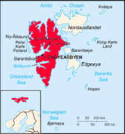
archipelago. It lies in the southern portion of Spitsbergen
Spitsbergen
Spitsbergen is the largest and only permanently populated island of the Svalbard archipelago in Norway. Constituting the western-most bulk of the archipelago, it borders the Arctic Ocean, the Norwegian Sea and the Greenland Sea...
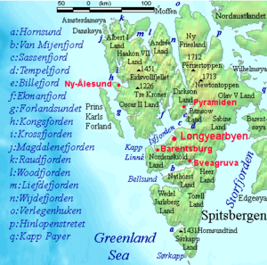
island. The fjord is 83 km (51.6 mi) long, entering the island from Bellsund
Bellsund
Bellsund is a 20 km long sound on the west coast of Spitsbergen, part of the Svalbard archipelago.-History:Bellsund was first seen by William Barents in 1596. He simply referred to it as Inwyck . In 1610 Jonas Poole explored Bellsund, giving the fjord the name it retains to this day. He named it...
in the west, south of Nordenskiöld Land
Nordenskiöld Land
Nordenskiöld Land is the land area between Isfjorden and Van Mijenfjorden on Spitsbergen, Svalbard.The area is named after Swedish explorer and geologist Nils Adolf Erik Nordenskiöld....
. The settlement of Sveagruva lies on the fjord's north bank.
The fjord is named after the Dutch
Netherlands
The Netherlands is a constituent country of the Kingdom of the Netherlands, located mainly in North-West Europe and with several islands in the Caribbean. Mainland Netherlands borders the North Sea to the north and west, Belgium to the south, and Germany to the east, and shares maritime borders...
whaler Willem Cornelisz. van Muyden
Willem Cornelisz. van Muyden
Willem Cornelisz. van Muyden was an early 17th century mariner. He is known in The Netherlands as De Eerste Walvisvanger...
, who was involved in the trade in 1612 and 1613. Van Mijenfjorden (an obvious corruption of Van Muyden's name) was originally called Low Sound, while the small cove north of Axel Island (at the mouth of the fjord) was called Van Muyden's Haven. This latter name was moved from its proper location by Giles and Rep (c. 1710) and "floated over" to where modern cartographers now wrongly place it.
External links


