
Vasastaden, Stockholm
Encyclopedia
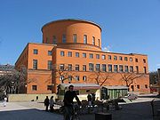
Swedish language
Swedish is a North Germanic language, spoken by approximately 10 million people, predominantly in Sweden and parts of Finland, especially along its coast and on the Åland islands. It is largely mutually intelligible with Norwegian and Danish...
for "Vasa City") is a 3.00 km² large city district
City district
City district is a type of administrative division of Pakistan and Croatia.It is also the English translation of German Stadtbezirk and Swedish Stadsdel.-See also:*City Districts of Pakistan...
in central Stockholm
Stockholm
Stockholm is the capital and the largest city of Sweden and constitutes the most populated urban area in Scandinavia. Stockholm is the most populous city in Sweden, with a population of 851,155 in the municipality , 1.37 million in the urban area , and around 2.1 million in the metropolitan area...
, Sweden
Sweden
Sweden , officially the Kingdom of Sweden , is a Nordic country on the Scandinavian Peninsula in Northern Europe. Sweden borders with Norway and Finland and is connected to Denmark by a bridge-tunnel across the Öresund....
. With 51,661 inhabitants it is the second most populous, as well as the second most densely populated (17,220/km²) district in Stockholm.
The major parks in Vasastaden are Vasaparken
Vasaparken (Stockholm)
Vasaparken is a park in Stockholm, Sweden, located in Vasastaden and named after the Royal Vasa Dynasty. The park lays between the two squares Odenplan and Sankt Eriksplan...
and Observatorielunden
Observatorielunden
Observatorielunden is a park in Stockholm's Vasastaden district. It stretches over the steep hill Observatoriekullen, one of the last remnants of Brunkebergsåsen, the esker that once reached across much of Norrmalm but was mostly levelled during the development of that district...
near the centre and Vanadislunden
Vanadislunden
Vanadislunden is a big park area in Stockholm, Sweden, located in Vasastaden.The area is named after Vanadis, which is another name for the Norse Goddess Freyja....
and Bellevueparken in the north.
Vasastaden proper
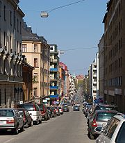
Vasagatan, Stockholm
Vasagatan is a major street in central Stockholm named after King Gustav Vasa.In its southern end it is connected to the old town Gamla Stan by the bridge Vasabron, from where it stretches north to the public square Norra Bantorget. It passes in front of the Stockholm Central Station and is...
, in its turn named after King Gustav Vasa
Gustav I of Sweden
Gustav I of Sweden, born Gustav Eriksson of the Vasa noble family and later known simply as Gustav Vasa , was King of Sweden from 1523 until his death....
in 1885, was still a peripheral part of the city in the early 1880s. Before the end of that decade, however, some 150 buildings had been built and only the properties along Odengatan remained vacant. The expansion was preceded by a city plan established in 1879, a slightly more modest edition of the 1866 intentions of city planner Albert Lindhagen
Albert Lindhagen
Klas Albert Lindhagen was a Swedish city planner, lawyer, and politician. He is mostly remembered for his city plans for Stockholm produced in the late 19th century.- Biography :...
, in its turn largely a continuation north of an original 17th century plan. Like the Baroque plan, the new plan took little or no account of local topographic variations, and where the two failed to reconcile, sites were simply set aside as parks or for major structures such as the Sabbatsberg Hospital.
Compared to central Stockholm, streets were widened to 18 metres, except for the main east-west-bound street Odengatan which was made 30 metres wide and adorned with plantings after continental prototypes. In accordance with construction charters from the 1870s, building corners where filleted and building heights adopted to street width and limited to five floors — embellishing proportions intended to bring light and air into the urban space. The Neo-Renaissance
Neo-Renaissance
Renaissance Revival is an all-encompassing designation that covers many 19th century architectural revival styles which were neither Grecian nor Gothic but which instead drew inspiration from a wide range of classicizing Italian modes...
plaster architecture of the middle class residential buildings in southern Vasastaden, much reminds of Ringstraße
Ringstraße
The Ringstraße is a circular road surrounding the Innere Stadt district of Vienna, Austria and is one of its main sights...
in Vienna
Vienna
Vienna is the capital and largest city of the Republic of Austria and one of the nine states of Austria. Vienna is Austria's primary city, with a population of about 1.723 million , and is by far the largest city in Austria, as well as its cultural, economic, and political centre...
; the ground floors are dominated by horizontal elements with column
Column
A column or pillar in architecture and structural engineering is a vertical structural element that transmits, through compression, the weight of the structure above to other structural elements below. For the purpose of wind or earthquake engineering, columns may be designed to resist lateral forces...
s and pilaster
Pilaster
A pilaster is a slightly-projecting column built into or applied to the face of a wall. Most commonly flattened or rectangular in form, pilasters can also take a half-round form or the shape of any type of column, including tortile....
s above, while accentuated cornice
Cornice
Cornice molding is generally any horizontal decorative molding that crowns any building or furniture element: the cornice over a door or window, for instance, or the cornice around the edge of a pedestal. A simple cornice may be formed just with a crown molding.The function of the projecting...
s closes the vertical compositions. Later architects failed to appreciate these Neo-Renaissance buildings and freed many of them of most of their decorations.
Birkastaden
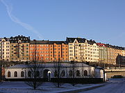
Birka
During the Viking Age, Birka , on the island of Björkö in Sweden, was an important trading center which handled goods from Scandinavia as well as Central and Eastern Europe and the Orient. Björkö is located in Lake Mälaren, 30 kilometers west of contemporary Stockholm, in the municipality of Ekerö...
, sometimes called Rörstrandsområdet (the "Rörstrand Area") which forms the compact northern frontier of Stockholm's historical city centre. As described above, Lindhagens original intentions for the elevated area was to keep it as a park featuring the 17th century avenue
Avenue (landscape)
__notoc__In landscaping, an avenue or allée is traditionally a straight route with a line of trees or large shrubs running along each, which is used, as its French source venir indicates, to emphasize the "coming to," or arrival at a landscape or architectural feature...
of Karlberg Palace
Karlberg Palace
Karlberg Palace is a palace by the Karlberg Canal on the border of Stockholm in Solna. The palace, built in 1630 and the oldest in Solna municipality, today houses the Military Academy Karlberg....
. In the city plan of 1879, however, the area was divided into two large blocks, which on a request from the local landowner, porcelain factory Rörstrand
Rörstrand
Rörstrand porcelain was one of the most famous Swedish porcelain manufacturers, with production initially at Karlberg Sea on Kungsholmen in Stockholm.-History:...
, in 1886 were split up into smaller properties. This resulted in a new city plan which was adopted to local topographic variations and therefore features non-perpendicular street crossings.
Few buildings were constructed before the turn of the century, but construction work soon boomed to culminate in 1905–06, speculation causing many buildings to change owners several times before their completion. Virtually all the buildings in Birkastaden are Art Nouveau
Art Nouveau
Art Nouveau is an international philosophy and style of art, architecture and applied art—especially the decorative arts—that were most popular during 1890–1910. The name "Art Nouveau" is French for "new art"...
, a result of both the brief construction period and the fact that some 50 buildings were designed by architects Dorph & Höög, at the time the largest architectural practice in Northern Europe. The buildings of Birkastan features oriel window
Oriel window
Oriel windows are a form of bay window commonly found in Gothic architecture, which project from the main wall of the building but do not reach to the ground. Corbels or brackets are often used to support this kind of window. They are seen in combination with the Tudor arch. This type of window was...
s, towers on the corners, rounded pediment
Pediment
A pediment is a classical architectural element consisting of the triangular section found above the horizontal structure , typically supported by columns. The gable end of the pediment is surrounded by the cornice moulding...
s and bright, plain plaster façades with thrifty decorations. As a result of speculation, the backyards are narrow, and many flats shadowy. From the start, however, Birkastan was a mixed area shared by both low and high income earners.
Röda Bergen
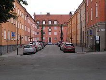
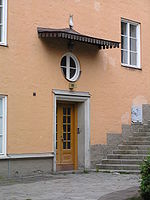
Lärkstaden
Lärkstaden is an urban area within the city district of Östermalm in central Stockholm, Sweden.The name originates from the large block "Lärkan" which used to dominated the area before the present buildings were built in 1907...
inspired by the ideas of Austrian architect Camillo Sitte
Camillo Sitte
Camillo Sitte was a noted Austrian architect, painter and city planning theoretician with great influence and authority of the development of urban construction planning and regulation in Europe.- Life :...
. His plan for Röda Bergen was adopted in 1909, but because of World War I most of these plans remained unrealised until the 1920s. In 1923 the plan, slightly modified by Sigurd Lewerentz
Sigurd Lewerentz
Sigurd Lewerentz . He was an architect, but initially trained as a mechanical engineer at the Chalmers University of Technology in Gothenburg . Later he took up an architectural apprenticeship in Germany...
, was finally established.
The buildings facing the surrounding blocks are traditional 5–6 floors residential buildings forming a wall around Röda Bergen. From the monumental eastern entrance, an avenue (Rödabergsgatan) leads west to a round elevated space where a church was originally planned. Perpendicular to this avenue, the heavily trafficked Torsgatan cuts through the area. The blocks within Röda Bergen are limited to 2–3 floors and most of the backyards are open in one end, which allows for plenty of sun light and series of spaces appealing to te eye. Hallman's design was a sharp break with the contemporary narrow, dark, and often filthy backyards. In contrast to them, the involved architects — including Björn Hedwall, Paul Hedqvist
Paul Hedqvist
Paul Hedqvist was a Swedish modernist architect with many official commissions in Sweden through the 1930s, including housing projects, major bridges, many schools, and urban planning work. His practice evolved into designing office towers and at least one major stadium in the postwar 1950s...
, and Sven Wallander — carefully detailed the façades and gables facing the interior with simple classical ornaments and warm red and yellow colours. Of the 2.500 flats in the area, many included novelties such as warm and cold water, WC, and even bath tubes, but most of them were small — half of them was a single room with a kitchen or even less.
Atlas
Sankt Eriksbron
Sankt Eriksbron is a bridge in central Stockholm, Sweden. Passing over Barnhusviken it connects Kungsholmen to Norrmalm. The present construction was inaugurated in 1937...
bridge was until the turn of century 1900 a heavily industrial district. The Atlas Area, east of the bridge and named after industrial company Atlas AB
Atlas Copco
Atlas Copco is a Swedish industrial company that was founded in 1873. It manufactures industrial tooling and equipment.The Atlas Copco Group is a global industrial group of companies headquartered in Stockholm, Sweden. Revenues for 2009 totaled 63 billion SEK. The Group employs more than 33,000...
whose workshops used to occupy the area, presents features unique to Stockholm. The plan for the area was passed in 1926 and construction works immediately followed. In contrast to the newly built Röda Bergen, much of which was built by HSB
HSB (Sweden)
HSB is a cooperative association for housing in Sweden. Members of the association are HSB's customers, i.e. individuals or groups that have bought properties from HSB. Any entity that buys any property from HSB will automatically become a member....
, the builders at Atlas were private entrepreneurs. While this resulted in a much criticized high exploitation, the city building committee in 1926 concluded the area could boast an intelligible order and a regularity the neighbouring Rörstrand Area still couldn't present notwithstanding recent redesign attempts.
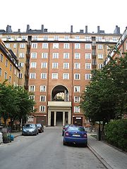
The most striking feature of Atlas is the level difference between the surround streets and the area itself. Like at Röda Bergen, the buildings delimiting Atlas form a coherent wall where the exterior façades are six floors tall while the interior façades are nine floors tall. The buildings inside the area are 5–6 floors, concealing the dark narrow backyards while separated by widened streets with plantations. The difference in level was solved by mean of monumental flights of stairs resulting in the tall porticoes leading into the area.
The flats in Atlas were small — 1–2 rooms and a kitchen — and dark — a result of exploitation and the wide building volumes — but featured modernities such as central heating and bathrooms. The reduced classical ornamentation and the perpendicular plan has, however, given the area a monumentality which is characteristic for the National Romantic
National Romantic Style
The National Romantic style was a Nordic architectural style that was part of the national romantic movement during the late 19th and early 20th century. Designers turned to early Medieval and even prehistoric precedents to construct a style appropriate to the perceived character of a people...
Swedish architecture of the 1920s. The contrast between the heavily trafficked surroundings streets and the calm interior of Atlas, brilliantly exposed through the large porticoes, still makes Atlas a popular area.

