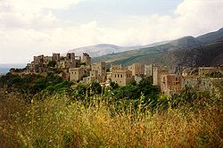
Vathia (Laconia), Greece
Encyclopedia
Vatheia is a little town in Laconia
, Greece
, on the Mani Peninsula
. It is part of the municipal unit Oitylo
. It is famous for its grand towers (pyrgoi). Vatheia is situated in a hilly setting, and is linked with the road linking north to Areopoli
and Kalamata
and south to Cape Tenaro/Matapan. The hills and mountains dominate the northern part, farmlands are within the valley areas, forests are rare and are only situated in and around the valley area. On the hilltops are abandoned homes, which are colored with earth and topaz along with its rooftops which are like fortresses and were built out of stone south of the place (plateia). Modern buildings exists in the centre. Now Vatheia is a tourist attraction in spring because of its wild flowers that cover the nearby hills and its breathtaking views.

Laconia
Laconia , also known as Lacedaemonia, is one of the regional units of Greece. It is part of the region of Peloponnese. It is situated in the southeastern part of the Peloponnese peninsula. Its administrative capital is Sparti...
, Greece
Greece
Greece , officially the Hellenic Republic , and historically Hellas or the Republic of Greece in English, is a country in southeastern Europe....
, on the Mani Peninsula
Mani Peninsula
The Mani Peninsula , also long known as Maina or Maïna, is a geographical and cultural region in Greece. Mani is the central peninsula of the three which extend southwards from the Peloponnese in southern Greece. To the east is the Laconian Gulf, to the west the Messenian Gulf...
. It is part of the municipal unit Oitylo
Oitylo
Oitylo is a village and a former municipality in Laconia, Peloponnese, Greece. Since the 2011 local government reform it is part of the municipality East Mani, of which it is a municipal unit. It is one of the oldest towns in the Mani Peninsula. It was mentioned in the Iliad by Homer as Oetylοs ,...
. It is famous for its grand towers (pyrgoi). Vatheia is situated in a hilly setting, and is linked with the road linking north to Areopoli
Areopoli
Areopoli is a town on the Mani Peninsula, Laconia, Greece. The word Areopoli means "city of Ares", the ancient Greek god of war. It was the seat of Oitylo municipality. Areopoli was called Tsimova by the invading Slavs during the 7th century AD...
and Kalamata
Kalamata
Kalamata is the second-largest city of the Peloponnese in southern Greece. The capital and chief port of the Messenia prefecture, it lies along the Nedon River at the head of the Messenian Gulf...
and south to Cape Tenaro/Matapan. The hills and mountains dominate the northern part, farmlands are within the valley areas, forests are rare and are only situated in and around the valley area. On the hilltops are abandoned homes, which are colored with earth and topaz along with its rooftops which are like fortresses and were built out of stone south of the place (plateia). Modern buildings exists in the centre. Now Vatheia is a tourist attraction in spring because of its wild flowers that cover the nearby hills and its breathtaking views.
Nearest places

- GerolimenasGerolimenasGerolimenas , also Yerolimenas, is a picturesque small coastal village at the southern end of the Mani Peninsula, in the prefecture of Laconia, in the Peloponnese, Greece. Τhe name, which means "Old Harbour", is thought to derive from the ancient "Ιερός Λιμήν" , meaning "Sacred Harbor"...
, northwest - Lagia, northeast
- AchilleioAchilleioAchilleio is a former municipality on the island of Corfu, Ionian Islands, Greece. Since the 2011 local government reform it is part of the municipality Corfu, of which it is a municipal unit. It is located in the south-central part of the island of Corfu, south of Corfu . It has a land area of...
, southeast
Historical population
| Year | Population | Change |
|---|---|---|
| 1981 | 60 | - |
| 1991 | 113 | 53/46.9% |
| 2001 | - | - |
External links
- Map and aerial photos:
- Street map: Street map from Mapquest, MapPoint or Google
- Satellite images: Google - image not yet available
- Panoramic photos of Vathia and Mani

