Vienna Danube regulation
Encyclopedia


Flood
A flood is an overflow of an expanse of water that submerges land. The EU Floods directive defines a flood as a temporary covering by water of land not normally covered by water...
engineering along the Danube
Danube
The Danube is a river in the Central Europe and the Europe's second longest river after the Volga. It is classified as an international waterway....
river in Vienna
Vienna
Vienna is the capital and largest city of the Republic of Austria and one of the nine states of Austria. Vienna is Austria's primary city, with a population of about 1.723 million , and is by far the largest city in Austria, as well as its cultural, economic, and political centre...
, Austria
Austria
Austria , officially the Republic of Austria , is a landlocked country of roughly 8.4 million people in Central Europe. It is bordered by the Czech Republic and Germany to the north, Slovakia and Hungary to the east, Slovenia and Italy to the south, and Switzerland and Liechtenstein to the...
during the last 150 years. The first major dams or levee
Levee
A levee, levée, dike , embankment, floodbank or stopbank is an elongated naturally occurring ridge or artificially constructed fill or wall, which regulates water levels...
s were built during 1870-75. Another major project was constructed during 1972-88, which created the New Danube
New Danube
The New Danube is a side channel on the eastern side of the Danube in Vienna, Austria. It was created to provide flood relief by containing excess water. The Donauinsel , made out of the removed material, separates the new waterway from the main channel of the river...
and Danube Island (Donauinsel
Donauinsel
The Donauinsel is a long, narrow island, in central Vienna, Austria, between the Danube river and the parallel excavated channel Neue Donau . The island is 21.1 km in length, but is only 70–210 metres broad...
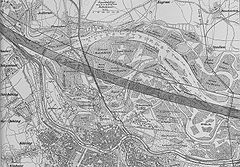
). Prior to regulation, the Danube in Vienna had been an 8-kilometre (5 mi) wide wetlands, as a patchwork of numerous streams meandering through the area (see maps at right).
History
In Vienna, the DanubeDanube
The Danube is a river in the Central Europe and the Europe's second longest river after the Volga. It is classified as an international waterway....
river up until 1870, was almost totally unregulated. The river flowed through the wetlands on the left (east) bank of today's Danube course. Villages (like Jedlesee, Floridsdorf and Stadlau) were near the former main branch of the Danube and were particularly at risk of being inundated by the floods of the river.
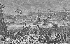
After repeated severe flood damage, by 1810, Hofbau-Direktor Josef von Schemerl had already proposed regulation in the form of a new river bed, but his plans were not realized. Only during the years 1870 to 1875, was the Danube regulated for the first time. On the left bank, a 450 metres (1,476.4 ft) wide flood-prone area (Inundationsgebiet) was created with the dam Hubertusallee, covering today's municipal districts of Floridsdorf and Donaustadt. The new main branch, including shipping, was 280 metres (918.6 ft) wide, leaving the old river bed as the Old Danube.
Major high water in the years 1897, 1899 and 1954, led to more floods, especially concerning the right bank of the Danube at Handelskai ("Trade pier"). This proved that the regulation of the Danube was still insufficient.
After many years of studies, in 1972, a new flood-control project was started. Working up to 1988, within the inundation area, a new, 210 metres (689 ft) wide channel (Entlastungsgerinne) was created. The material excavated from the channel was placed between the Danube and the channel, creating the Danube Island. The channel, or New Danube, is protected by fortifications and is only used to divert flood waters. It is designed for a flow of 5000 m3/s. Overall, the Danube regulation is designed for a capacity of up to 14000 m3/s, which is the estimated maximum flow of a flooding which took place in 1501. The Danube Island (also called "Copa Kagrana" after the Brazilian "Copa Cabana and the adjoining Kagran, a suburb of Vienna) and the New Danube now serves as a popular recreation area.
Flood years and levels
Major floods in Vienna were:| Year | Water flow | Comparable level at the Reichsbrücke Reichsbrücke The Reichsbrücke is Vienna's most famous bridge, linking Mexicoplatz in Leopoldstadt with the Donauinsel in Donaustadt on the other side of the Danube. It lies on an important axis leading from the city centre at Stephansplatz, through Praterstern, and on to Kagran in the north-east... |
||
|---|---|---|---|---|
| m3/s | cu ft/s | m | ft | |
| 1501 | 14000 | 494,405.3 | 10.3 | 33.8 |
| 1899 | 10500 | 370,804 | 8.66 | 28.4 |
| 1954 | 9600 | 339,020.8 | 8.61 | 28.2 |
| 1975 | 8560 | 302,293.5 | 8.04 | 26.4 |
| 1991 | 9600 | 339,020.8 | 8 | 26.2 |
| 2002 | 10000 | 353,146.7 | 8.63 | 28.3 |
See also
A series of articles on regulation of the Danube in chronological order- Internationalization of the Danube RiverInternationalization of the Danube RiverThe Danube River has been a trade waterway for centuries, but with the rise of international borders and the jealousies of national states, commerce and shipping has often been hampered for narrow reasons. In addition, natural features of the river, most notably the sanding of the delta, has often...
, for events from earliest times to the Treaty of Paris in 1856 - Commissions of the Danube RiverCommissions of the Danube RiverSee Internationalization of the Danube River for events before 1856.The Commissions of the Danube River were authorized by the Treaty of Paris after the close of the Crimean War...
, for the international bodies governing the waterway from 1856 to 1940 - Nazi rule over the Danube RiverNazi rule over the Danube RiverNazi rule over the Danube River was brought about by force of arms, through annexation of Austria, invasion of Yugoslavia and of the Soviet Union and treaties with the Kingdom of Romania and Hungary, but a legal cover was provided through moves that resulted in a new international order on the...
- Danube River Conference of 1948Danube River Conference of 1948The Danube River Conference of 1948 was held in Belgrade, Yugoslavia, to develop a new international regime for the development and control of the Danube in the wake of World War II...
- Danube CommissionDanube CommissionThe Danube Commission is concerned with the maintenance and improvement of navigation conditions of the Danube River, from its source in Germany to its outlets in Romania and Ukraine, leading to the Black Sea. It was established in 1948 by seven countries bordering the river, replacing previous...
, for events since 1948 - International Commission for the Protection of the Danube RiverInternational Commission for the Protection of the Danube RiverThe International Commission for the Protection of the Danube River is an international organisation with its permanent secretariat in Vienna. It was established by the Danube River Protection Convention, signed by the Danube countries in Sofia, Bulgaria, in 1994.The commission became active in 1998...
, for the organization established in 1998 and charged with environmental and ecological activities

