Villalbos
Encyclopedia
| Villalbos Village | |
|---|---|
View |
Villalbos  |
 |
|
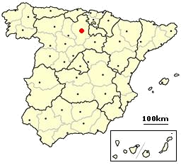
| Province | Burgos Burgos (province) The province of Burgos is a province of northern Spain, in the northeastern part of the autonomous community of Castile and León. It is bordered by the provinces of Palencia, Cantabria, Vizcaya, Álava, La Rioja, Soria, Segovia, and Valladolid. Its capital is the city of Burgos...  |
| Autonomous community | Castilla y León  |
| Postal code Postal code A postal code is a series of letters and/or digits appended to a postal address for the purpose of sorting mail. Once postal codes were introduced, other applications became possible.In February 2005, 117 of the 190 member countries of the Universal Postal Union had postal code systems... |
09258 |
| Coordinates - Latitude: - Longitude: |
42° Degree (angle) A degree , usually denoted by ° , is a measurement of plane angle, representing 1⁄360 of a full rotation; one degree is equivalent to π/180 radians... 46' Minute A minute is a unit of measurement of time or of angle. The minute is a unit of time equal to 1/60th of an hour or 60 seconds. In the UTC time scale, a minute on rare occasions has 59 or 61 seconds; see leap second. The minute is not an SI unit; however, it is accepted for use with SI units... N North North is a noun, adjective, or adverb indicating direction or geography.North is one of the four cardinal directions or compass points. It is the opposite of south and is perpendicular to east and west.By convention, the top side of a map is north.... 3º19' W West West is a noun, adjective, or adverb indicating direction or geography.West is one of the four cardinal directions or compass points. It is the opposite of east and is perpendicular to north and south.By convention, the left side of a map is west.... |
| Altitude Altitude Altitude or height is defined based on the context in which it is used . As a general definition, altitude is a distance measurement, usually in the vertical or "up" direction, between a reference datum and a point or object. The reference datum also often varies according to the context... |
860 m |
| Surface Surface In mathematics, specifically in topology, a surface is a two-dimensional topological manifold. The most familiar examples are those that arise as the boundaries of solid objects in ordinary three-dimensional Euclidean space R3 — for example, the surface of a ball... |
km² |
| Distance Distance Distance is a numerical description of how far apart objects are. In physics or everyday discussion, distance may refer to a physical length, or an estimation based on other criteria . In mathematics, a distance function or metric is a generalization of the concept of physical distance... s |
17 km to Belorado Belorado Belorado is a village and municipality in Spain, belonging to the Province of Burgos, in the autonomous community of Castile-Leon. It has a population of approximately 2,100 inhabitants. As well is known for being a city in the Way of Saint James.... 39 km to Burgos Burgos Burgos is a city of northern Spain, historic capital of Castile. It is situated at the edge of the central plateau, with about 178,966 inhabitants in the city proper and another 20,000 in its suburbs. It is the capital of the province of Burgos, in the autonomous community of Castile and León... |
| Population - Total (census of 2007) - Density |
25 inhab. hab./km² |
| Demonym Demonym A demonym , also referred to as a gentilic, is a name for a resident of a locality. A demonym is usually – though not always – derived from the name of the locality; thus, the demonym for the people of England is English, and the demonym for the people of Italy is Italian, yet, in english, the one... |
Villalbés |
| River | Oca |
| Mayor (2007- ) | Isabel Bonilla Calleja (Partido Popular People's Party (Spain) The People's Party is a conservative political party in Spain.The People's Party was a re-foundation in 1989 of the People's Alliance , a party led and founded by Manuel Fraga Iribarne, a former Minister of Tourism during Francisco Franco's dictatorship... ) |
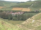
Villalbos
 is a small village in the north-east of Burgos Province, autonomous community of Castilla-Leon (Spain).
Geography
Villalbos is located in the left border of Oca River that leads to Ebro river.Wikimapia\Coordenadas: 42°26'40"N 3°19'47"W
History
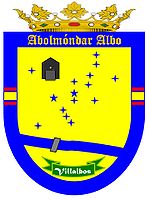
At the beginning of 10th Century a Castilian count, don Rodrigo Díaz, known as "Abolmondar Albo" in the mozarabic world, founded a settlement next to the Oca river. From those settlements came the actual towns of Villalmondar (Abolmondar) and Villalbos (Albos).Church
The Catholic Church of Saint Thomas Apostle was built in the past but it still keeps the Bell's Tower, the main Latin cross plant and the cemetery.Demography
| 1842 | 1857 | 1860 | 1877 | 1887 | 1897 | 1900 | 1910 | 1920 | 2007 | ||||||||
|---|---|---|---|---|---|---|---|---|---|---|---|---|---|---|---|---|---|
| 109 | 153 | 169 | 124 | 116 | 126 | 120 | 133 | 129 |
External links
- http://www.everyoneweb.com/villalbos/ Villalbos "Abolmondar Albo's Land" (in Spanish)
- http://webs.ono.com/villalbos/ (Un-Official Web in Spanish Language)

