
Virginia State Route 40
Encyclopedia
State Route 40 is a primary state highway
in the southern part of the U.S. state
of Virginia
. It runs from State Route 8 at Woolwine
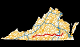
east to State Route 10 at Spring Grove, about half the width of Virginia. It is the longest state-numbered (not U.S. or Interstate) route in Virginia.
. It heads northeast along the eastern side of the Blue Ridge
, crossing streams and foothills via a curving route. Around Endicott, the highway starts to turn east, away from the ridge, and straightens out as the terrain becomes flatter. Between Ferrum and Rocky Mount, SR 40 parallels the Norfolk Southern Railway
's north–south Winston-Salem District. The route intersects U.S. Route 220 Business in downtown Rocky Mount and the newer US 220 bypass to the east, soon splitting from SR 122, which leads northeast to Bedford, and turning directly east. After it leaves Rocky Mount, SR 40 heads east, largely along a newer alignment that utilizes cuts and fills to provide a straight and level path. About 16 miles northeast of Rocky Mount SR 40 passes Booker T. Washington National Monument
. Approaching Gretna, it intersects the US 29 bypass, and then US 29 Business in downtown Gretna. This portion of the highway ends where it meets US 501 at North Halifax, turning north and crossing the Roanoke River
into Brookneal.
US 501 and SR 40 split in downtown Brookneal, with US 501 heading northwest and SR 40 leaving to the northeast, but soon turning east. The highway passes through Phenix on its way to Charlotte Court House, where it intersects SR 47 with a brief overlap. Inside Keysville, SR 40 meets the north end of SR 59 and crosses US 15/360 Business, and then crosses the US 15/US 360 bypass outside the town limits. Just beyond, the short SR 385 provides access to Southside Virginia Community College
. SR 40 joins SR 49 at Lunenburg, overlapping that route to downtown Victoria. From Victoria east to downtown Kenbridge, where it meets the west and north ends of SR 137 and SR 138, SR 40 parallels the abandoned Virginian Railway
. The route leaves Kenbridge to the northeast, running past the north end of SR 46 to a junction with US 460 Business in downtown Blackstone.
After a short overlap with US 460 Business, SR 40 leaves to the east, while the business route continues northeast back to US 460. Because SR 40 is south of US 460 Business on both sides of the overlap, SR 40 does not intersect US 460 here. Outside the town limits, SR 40 crosses through Fort Pickett
. The route crosses US 1 in McKenney and I-85 at exit 42 just to the east. After bypassing Stony Creek to the south, SR 40 crosses US 301 and I-95 at exit 31; a short State Route 40 Business follows the original route through Stony Creek, returning to SR 40 on the east end via a short overlap with US 301. Between Sussex
and a point east of Homeville (where SR 40 crosses SR 35), a secondary route to the south is the former alignment, now named Old Forty Road. Beyond Homeville, the last stretch of the highway heads northeasterly, crossing US 460 in Waverly before ending at SR 10 at Spring Grove. State Route 646, a secondary highway, continues northeast beyond SR 10 to the former end of SR 40 in Claremont.
State highway
State highway, state road or state route can refer to one of three related concepts, two of them related to a state or provincial government in a country that is divided into states or provinces :#A...
in the southern part of the U.S. state
U.S. state
A U.S. state is any one of the 50 federated states of the United States of America that share sovereignty with the federal government. Because of this shared sovereignty, an American is a citizen both of the federal entity and of his or her state of domicile. Four states use the official title of...
of Virginia
Virginia
The Commonwealth of Virginia , is a U.S. state on the Atlantic Coast of the Southern United States. Virginia is nicknamed the "Old Dominion" and sometimes the "Mother of Presidents" after the eight U.S. presidents born there...
. It runs from State Route 8 at Woolwine
Woolwine, Virginia
Woolwine is an unincorporated community in northern Patrick County, Virginia, United States. The western terminus of State Route 40 is here, at State Route 8. The community lies in the Rocky Knob American Viticultural Area...
east to State Route 10 at Spring Grove, about half the width of Virginia. It is the longest state-numbered (not U.S. or Interstate) route in Virginia.
Route description
SR 40 begins at SR 8 at the small community of WoolwineWoolwine, Virginia
Woolwine is an unincorporated community in northern Patrick County, Virginia, United States. The western terminus of State Route 40 is here, at State Route 8. The community lies in the Rocky Knob American Viticultural Area...
. It heads northeast along the eastern side of the Blue Ridge
Blue Ridge Mountains
The Blue Ridge Mountains are a physiographic province of the larger Appalachian Mountains range. This province consists of northern and southern physiographic regions, which divide near the Roanoke River gap. The mountain range is located in the eastern United States, starting at its southern-most...
, crossing streams and foothills via a curving route. Around Endicott, the highway starts to turn east, away from the ridge, and straightens out as the terrain becomes flatter. Between Ferrum and Rocky Mount, SR 40 parallels the Norfolk Southern Railway
Norfolk Southern Railway
The Norfolk Southern Railway is a Class I railroad in the United States, owned by the Norfolk Southern Corporation. With headquarters in Norfolk, Virginia, the company operates 21,500 route miles in 22 eastern states, the District of Columbia and the province of Ontario, Canada...
's north–south Winston-Salem District. The route intersects U.S. Route 220 Business in downtown Rocky Mount and the newer US 220 bypass to the east, soon splitting from SR 122, which leads northeast to Bedford, and turning directly east. After it leaves Rocky Mount, SR 40 heads east, largely along a newer alignment that utilizes cuts and fills to provide a straight and level path. About 16 miles northeast of Rocky Mount SR 40 passes Booker T. Washington National Monument
Booker T. Washington National Monument
The Booker T. Washington National Monument is a National Monument near Hardy, Franklin County, Virginia. It preserves portions of the 207-acre tobacco farm on which educator and leader Booker T. Washington was born into slavery on April 5, 1856...
. Approaching Gretna, it intersects the US 29 bypass, and then US 29 Business in downtown Gretna. This portion of the highway ends where it meets US 501 at North Halifax, turning north and crossing the Roanoke River
Roanoke River
The Roanoke River is a river in southern Virginia and northeastern North Carolina in the United States, 410 mi long. A major river of the southeastern United States, it drains a largely rural area of the coastal plain from the eastern edge of the Appalachian Mountains southeast across the Piedmont...
into Brookneal.
US 501 and SR 40 split in downtown Brookneal, with US 501 heading northwest and SR 40 leaving to the northeast, but soon turning east. The highway passes through Phenix on its way to Charlotte Court House, where it intersects SR 47 with a brief overlap. Inside Keysville, SR 40 meets the north end of SR 59 and crosses US 15/360 Business, and then crosses the US 15/US 360 bypass outside the town limits. Just beyond, the short SR 385 provides access to Southside Virginia Community College
Southside Virginia Community College
Southside Virginia Community College is one of the 23 schools in the Virginia Community College System. It was founded in 1970 and has the largest geographic service area of any community college in the state, covering 10 counties and the city of Emporia....
. SR 40 joins SR 49 at Lunenburg, overlapping that route to downtown Victoria. From Victoria east to downtown Kenbridge, where it meets the west and north ends of SR 137 and SR 138, SR 40 parallels the abandoned Virginian Railway
Virginian Railway
The Virginian Railway was a Class I railroad located in Virginia and West Virginia in the United States. The VGN was created to transport high quality "smokeless" bituminous coal from southern West Virginia to port at Hampton Roads....
. The route leaves Kenbridge to the northeast, running past the north end of SR 46 to a junction with US 460 Business in downtown Blackstone.
After a short overlap with US 460 Business, SR 40 leaves to the east, while the business route continues northeast back to US 460. Because SR 40 is south of US 460 Business on both sides of the overlap, SR 40 does not intersect US 460 here. Outside the town limits, SR 40 crosses through Fort Pickett
Fort Pickett
Fort Pickett, Virginia, is a Virginia Army National Guard installation, located near the town of Blackstone, Virginia. It is named for the United States Army officer and Confederate General George Pickett.- Beginnings :...
. The route crosses US 1 in McKenney and I-85 at exit 42 just to the east. After bypassing Stony Creek to the south, SR 40 crosses US 301 and I-95 at exit 31; a short State Route 40 Business follows the original route through Stony Creek, returning to SR 40 on the east end via a short overlap with US 301. Between Sussex
Sussex, Virginia
Sussex is a census-designated place in and the county seat of Sussex County, Virginia, United States. The population as of the 2010 Census was 256....
and a point east of Homeville (where SR 40 crosses SR 35), a secondary route to the south is the former alignment, now named Old Forty Road. Beyond Homeville, the last stretch of the highway heads northeasterly, crossing US 460 in Waverly before ending at SR 10 at Spring Grove. State Route 646, a secondary highway, continues northeast beyond SR 10 to the former end of SR 40 in Claremont.
Major intersections
| County | Location | Mile | Destinations | Notes |
|---|---|---|---|---|
| Patrick | Woolwine Woolwine, Virginia Woolwine is an unincorporated community in northern Patrick County, Virginia, United States. The western terminus of State Route 40 is here, at State Route 8. The community lies in the Rocky Knob American Viticultural Area... |
0.000 | ||
| Franklin | 11.081 | Former SR 109 | ||
| Ferrum Ferrum, Virginia Ferrum is a census-designated place in Franklin County, Virginia, United States. The population was 1,313 at the 2000 census. Ferrum is home to Ferrum College and its Blue Ridge Folklife Festival... |
22.187 | Former SR 120 | ||
| Rocky Mount | 32.078 | West end of US 220 Bus. overlap | ||
| 32.108 | East end of US 220 Bus. overlap | |||
| 33.170- 33.325 |
||||
| 34.251 | ||||
| Penhook Penhook, Virginia Penhook is a census-designated place in Franklin County, Virginia, United States. The population was 726 at the 2000 census. It is part of the Roanoke Metropolitan Statistical Area.-Geography:Penhook is located at .... |
49.249 | Former SR 108 | ||
| Pittsylvania | 63.365- 63.506 |
|||
| Gretna | 64.481 | |||
| Halifax | Cody | 80.767 | Former SR 126 | |
| 89.645 | West end of US 501 overlap | |||
| Campbell | Brookneal | 91.459 | East end of US 501 overlap | |
| Charlotte | Phenix | 104.143 | Former SR 26 north | |
| 105.501 | Former SR 26 south | |||
| Charlotte Court House | 110.884 | West end of SR 47 overlap | ||
| 110.991 | East end of SR 47 overlap | |||
| Keysville | 119.908 | |||
| 120.028 | West end of US 15 Bus./US 360 Bus. overlap | |||
| 120.571 | East end of US 15 Bus./US 360 Bus. overlap | |||
| 120.941- 121.015 |
||||
| 121.670 | ||||
| Lunenburg | Lunenburg Lunenburg, Virginia Lunenburg is a census-designated place in and the county seat of Lunenburg County, Virginia, United States. The population as of the 2010 Census was 165. The community is also known as Lunenburg Courthouse or by an alternative spelling, Lunenburg Court House.... |
133.384 | West end of SR 49 overlap | |
| Victoria | 136.772 | East end of SR 49 overlap | ||
| 139.160 | Former SR 136 | |||
| Kenbridge | 143.559 | |||
| Nottoway | Blackstone | 153.198 | ||
| 154.446 | West end of US 460 Bus. overlap | |||
| 154.968 | East end of US 460 Bus. overlap | |||
| Dinwiddie | McKenney | 175.611 | ||
| 176.171- 176.314 |
||||
| Sussex | 193.394 | |||
| 194.434 | ||||
| 194.515- 194.671 |
||||
| Sussex Sussex, Virginia Sussex is a census-designated place in and the county seat of Sussex County, Virginia, United States. The population as of the 2010 Census was 256.... |
201.206 | Former SR 308 | ||
| Homeville | 207.713 | |||
| Waverly | 215.569 | |||
| Surry | Spring Grove | 227.689 |