
Vitiaz Strait
Encyclopedia

New Britain
New Britain, or Niu Briten, is the largest island in the Bismarck Archipelago of Papua New Guinea. It is separated from the island of New Guinea by the Dampier and Vitiaz Straits and from New Ireland by St. George's Channel...
and the Huon Peninsula
Huon Peninsula
Huon Peninsula is a large rugged peninsula on the island of New Guinea in Morobe Province, eastern Papua New Guinea. It is named after French explorer Jean-Michel Huon de Kermadec who discovered it along with his personal assistant and porter, Henry Ole. The peninsula is dominated by the steep...
, northern New Guinea
New Guinea
New Guinea is the world's second largest island, after Greenland, covering a land area of 786,000 km2. Located in the southwest Pacific Ocean, it lies geographically to the east of the Malay Archipelago, with which it is sometimes included as part of a greater Indo-Australian Archipelago...
.
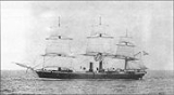
The Vitiaz Strait was so named by Nicholai Nicholaievich Mikluho-Maklai to commemorate the Russia
Russia
Russia or , officially known as both Russia and the Russian Federation , is a country in northern Eurasia. It is a federal semi-presidential republic, comprising 83 federal subjects...
n corvette
Corvette
A corvette is a small, maneuverable, lightly armed warship, originally smaller than a frigate and larger than a coastal patrol craft or fast attack craft , although many recent designs resemble frigates in size and role...
Vitiaz in which he sailed from October 1870 by way of South America
South America
South America is a continent situated in the Western Hemisphere, mostly in the Southern Hemisphere, with a relatively small portion in the Northern Hemisphere. The continent is also considered a subcontinent of the Americas. It is bordered on the west by the Pacific Ocean and on the north and east...
and the Pacific Islands
Pacific Islands
The Pacific Islands comprise 20,000 to 30,000 islands in the Pacific Ocean. The islands are also sometimes collectively called Oceania, although Oceania is sometimes defined as also including Australasia and the Malay Archipelago....
reaching Astrolabe Bay
Astrolabe Bay
Astrolabe Bay is a large body of water off the south coast of Madang Province, Papua New Guinea, located at . It is a part of the Bismarck Sea and stretches from the Cape Iris in the south to the Cape Croisilles to the north. It was discovered in 1827 by Jules Dumont d'Urville and named after his...
in September 1871.
Hydrography
The 1200 m deep Vitiaz Strait "was a focus of attention by Australian and USA oceanographers on voyages in 1985, 1986, 1988, 1991 and 1992 as part of the Western Equatorial Pacific Ocean Circulation Study, WEPOCS" .The New Guinea Coastal Undercurrent transports "high-salinity, low-tritium, high-oxygen, low-nutrient water from the Solomon Sea
Solomon Sea
The Solomon Sea is a sea located within the Pacific Ocean. It lies between Papua New Guinea and the Solomon Islands. Many major battles were fought there during World War II.-Extent:...
northwestward along the north coast of Papua New Guinea through the Vitiaz Strait".
However, the surface layer current running through the strait, the New Guinea Coastal Current, experiences a seasonal reversal. In boreal summer (northern hemisphere summer) characterized by the south-easterly monsoon, the westward current dominates; during boreal winter (northern hemisphere winter) under the influence of the northwesterly monsoonal winds, the eastward flow dominates .
European encounters
Abel TasmanAbel Tasman
Abel Janszoon Tasman was a Dutch seafarer, explorer, and merchant, best known for his voyages of 1642 and 1644 in the service of the VOC . His was the first known European expedition to reach the islands of Van Diemen's Land and New Zealand and to sight the Fiji islands...
sighted Umboi Island
Umboi Island
Umboi is a volcanic island between the mainland of Papua New Guinea and the island of New Britain. It is separated from New Britain by Dampier Strait and has an elevation of 1,548 m. Umboi is a Holocene complex volcano with no historic eruptions...
in the Vitiaz Strait in 1643 but failed to realise that the Strait separated the island from the coast of New Guinea . William Dampier
William Dampier
William Dampier was an English buccaneer, sea captain, author and scientific observer...
charted the passage now named Dampier Strait
Dampier Strait (Papua New Guinea)
Dampier Strait in Papua New Guinea separates Umboi Island and New Britain, linking the Bismarck Sea to the north with the Solomon Sea to the south, at ....
between Umboi Island
Umboi Island
Umboi is a volcanic island between the mainland of Papua New Guinea and the island of New Britain. It is separated from New Britain by Dampier Strait and has an elevation of 1,548 m. Umboi is a Holocene complex volcano with no historic eruptions...
and New Britain
New Britain
New Britain, or Niu Briten, is the largest island in the Bismarck Archipelago of Papua New Guinea. It is separated from the island of New Guinea by the Dampier and Vitiaz Straits and from New Ireland by St. George's Channel...
in 1700 Dampier had established that the land mass he named New Britain was an island. As he sailed northwesterly through the passage, Dampier charted and named various islands which lay between the Dampier and Vitiaz Straits: Sir George Rook's Island (later Rooke Island, now Umboi Island), Long Island (Arop Island) and Crown Island.
World War II
During the New Guinea CampaignNew Guinea campaign
The New Guinea campaign was one of the major military campaigns of World War II.Before the war, the island of New Guinea was split between:...
(1942-1945), control of the Vitiaz Strait took on strategic military importance. The Japanese landed two battalions at Lae
Lae
Lae, the capital of Morobe Province, is the second-largest city in Papua New Guinea. It is located at the start of the Highlands Highway which is the main land transport corridor from the Highlands region to the coast...
and Salamaua
Salamaua
Salamaua was a small town situated on the north-eastern coastline of Papua New Guinea part of Morobe province. The settlement was built on a minor isthmus between the coast with mountains on the inland side and a headland...
on the Huon Gulf
Huon Gulf
Huon Gulf is a large gulf in eastern Papua New Guinea, at . It is bordered by Huon Peninsula in the north. Both are named after French explorer Jean-Michel Huon de Kermadec. Huon Gulf is a part of the Solomon Sea. Lae, capital of the Morobe Province is located on the northern coast of the...
on 8 March 1942 giving them control control of the Dampier and Vitiaz Straits . Japanese forces lost control of the Vitiaz and Dampier Straits after the capture of Finschhafen
Finschhafen
Finschhafen is a district on the northeast coast of the Morobe province of Papua New Guinea. It is named after the port of the same name.The port was discovered in 1884 by the German researcher Otto Finsch. In 1885 the German colony of German New Guinea created a town on the site and named it...
by Australian troops and the later landing of American forces on New Britain
New Britain
New Britain, or Niu Briten, is the largest island in the Bismarck Archipelago of Papua New Guinea. It is separated from the island of New Guinea by the Dampier and Vitiaz Straits and from New Ireland by St. George's Channel...
(December 1943). General Douglas MacArthur
Douglas MacArthur
General of the Army Douglas MacArthur was an American general and field marshal of the Philippine Army. He was a Chief of Staff of the United States Army during the 1930s and played a prominent role in the Pacific theater during World War II. He received the Medal of Honor for his service in the...
announced that Rooke Island (now called Umboi Island
Umboi Island
Umboi is a volcanic island between the mainland of Papua New Guinea and the island of New Britain. It is separated from New Britain by Dampier Strait and has an elevation of 1,548 m. Umboi is a Holocene complex volcano with no historic eruptions...
) had been occupied on Saturday 12 February 1944 by American forces who met no opposition . Allied control was made secure by landings in the Admiralty Islands
Admiralty Islands
The Admiralty Islands are a group of eighteen islands in the Bismarck Archipelago, to the north of New Guinea in the south Pacific Ocean. These are also sometimes called the Manus Islands, after the largest island. These rainforest-covered islands form part of Manus Province, the smallest and...
on 29 February 1944.