Votorantim
Encyclopedia

São Paulo (state)
São Paulo is a state in Brazil. It is the major industrial and economic powerhouse of the Brazilian economy. Named after Saint Paul, São Paulo has the largest population, industrial complex, and economic production in the country. It is the richest state in Brazil...
in Brazil
Brazil
Brazil , officially the Federative Republic of Brazil , is the largest country in South America. It is the world's fifth largest country, both by geographical area and by population with over 192 million people...
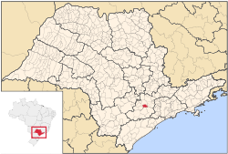
with an estimated population of 107,157 as of 2006. The city is located about 100 km away from the capital of the state
São Paulo
São Paulo is the largest city in Brazil, the largest city in the southern hemisphere and South America, and the world's seventh largest city by population. The metropolis is anchor to the São Paulo metropolitan area, ranked as the second-most populous metropolitan area in the Americas and among...
. It has 147 km² of rural
Rural
Rural areas or the country or countryside are areas that are not urbanized, though when large areas are described, country towns and smaller cities will be included. They have a low population density, and typically much of the land is devoted to agriculture...
area, 30 km² of urban area
Urban area
An urban area is characterized by higher population density and vast human features in comparison to areas surrounding it. Urban areas may be cities, towns or conurbations, but the term is not commonly extended to rural settlements such as villages and hamlets.Urban areas are created and further...
and a total area of 177 km².
Geography
It is located in a mountainous region and it has an average altitude of 557m. The city has a tropical weather and annual average temperature is 20 degrees. It makes borders with the cities of SorocabaSorocaba
Sorocaba is a city in the state of São Paulo, Brazil. Sorocaba is the fourth largest city in the state of São Paulo. Outside the Greater São Paulo region, it ranks behind only Campinas, Sao Jose dos Campos and Ribeirão Preto...
, Piedade
Piedade
-=*Piedade , a city in the State of São Paulo*Piedade, Rio de Janeiro, is a barrio in the city of Rio de Janeiro, in the state of Rio de Janeiro:=In the archipelago of the Azores:...
, Ibiúna
Ibiúna
Ibiúna is a municipality in the state of São Paulo in Brazil. The population in 2004 is 72,181 and the area is 1062.1 km². The elevation is 860 m...
, Salto de Pirapora
Salto de Pirapora
Salto de Pirapora is a municipality in the state of São Paulo in Brazil. The population in 2004 was 40,063 and the area is 281.67 km². The elevation is 630 m....
and Alumínio
Alumínio
Alumínio is a Brazilian city of the state of São Paulo. The population in 2003 is 16,019 and the area is 83.7 km². Its latitude is 23.5331/23°32'6" S and the longitude is 47.5625/47°15'43" W The elevation is 790 m. Alumínio is located east of Sorocaba and is also a suburban area...
. It is one of the main industrial areas of the State, with important access ways to highways such as Castello Branco (SP-280), Raposo Tavares (SP-270), João Leme dos Santos (SP-264) and SP-79 which binds the city to the south coast of the State.
Trivia
- It is also the self proclaimed Brazilian Capital of Cement. Much of the cement used in Brazil is of the Votorantim brand.

