WAIS Divide
Encyclopedia
The West Antarctic Ice Sheet (WAIS) Divide is a deep ice core drilling project run by the United States Antarctic Program
(USAP) and funded by the National Science Foundation
(NSF). The general purpose of the WAIS Divide project is to collect a deep ice core
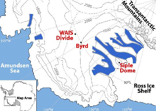
from the flow divide in central West Antarctica that can be used for scientific analysis and research. Specifically, scientists are looking to create the largest and most detailed record of greenhouse gases possible for the last 100,000 years, and also plan to look at the role climate change could have had on these amounts.

The WAIS Divide project will begin its 2010/2012 field season in November 2010, with the goal of reaching the target depth. Additional work is planned for two more seasons beyond that, including borehole analysis and replicate coring.
epoch, and about 300 to 500 years for the last glacial period.
. With the undisturbed and ideal nature of ice at the WAIS Divide, scientists are planning to come up with some of the best and most detailed research in greenhouse gases, hemispherical climate changes and how these interrelate. These results will in turn be used to take a broader look at global warming
, one of the main issues that faces mankind. While significant ice core sampling and detailed related research has been done in Greenland, the WAIS Divide project marks the first Southern Hemisphere and Antarctic venture of this kind.
In addition to studying climate and related changes, the WAIS Divide project will be able to measure many other gases (greenhouse and non-greenhouse) and their isotopes with unprecedented precision and resolution.

, from ice cores drilled en route to Lake Vostok
to the icy lids covering the lakes in the McMurdo Dry Valleys
.
United States Antarctic Program
United States Antarctic Program is an organization of the United States government which has presence in the continent of Antarctica. It co-ordinates research and the operational support for research in the region...
(USAP) and funded by the National Science Foundation
National Science Foundation
The National Science Foundation is a United States government agency that supports fundamental research and education in all the non-medical fields of science and engineering. Its medical counterpart is the National Institutes of Health...
(NSF). The general purpose of the WAIS Divide project is to collect a deep ice core
Ice core
An ice core is a core sample that is typically removed from an ice sheet, most commonly from the polar ice caps of Antarctica, Greenland or from high mountain glaciers elsewhere. As the ice forms from the incremental build up of annual layers of snow, lower layers are older than upper, and an ice...
from the flow divide in central West Antarctica that can be used for scientific analysis and research. Specifically, scientists are looking to create the largest and most detailed record of greenhouse gases possible for the last 100,000 years, and also plan to look at the role climate change could have had on these amounts.

History
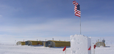
The WAIS Divide project began during the 2005/2006 field season when the first team of scientists established the seasonal field camp and began construction on the ice core handling and processing facility. During this first season, they also dug a few shallow ice cores to test out the site. Over the 2006/2007 season, work continued on the arch handing and processing facility, as well as set up for the eventual Deep Ice Sheet Coring (DISC) drill. At the end of the 2009/2010 field season, the project had reached a depth of 2,564 meters, with a targeted depth of about 3,330 meters, about 100 meters above bedrock.The WAIS Divide project will begin its 2010/2012 field season in November 2010, with the goal of reaching the target depth. Additional work is planned for two more seasons beyond that, including borehole analysis and replicate coring.
Site selection
In order to the get the necessary types of ice core samples for successful research, scientists sought out an area of the Antarctic Continent that would be the most beneficial. The WAIS Divide was chosen because of the relative smoothness of the bed topography, the fact that the internal layers of ice are flat and undisturbed, and that the annual layers, each about 1 cm thick, will be detectable to at least 40,000 years within the ice sheet. Also significant is the fact that at the WAIS Divide, there is minimal horizontal ice flow, which guarantees more accurate data due to the ability to pin-point the specific atmospheric conditions in the same location as the ice sheet. One last important fact about the WAIS Divide location is the significance that the gas-age to ice-age difference is about 200 years for the HoloceneHolocene
The Holocene is a geological epoch which began at the end of the Pleistocene and continues to the present. The Holocene is part of the Quaternary period. Its name comes from the Greek words and , meaning "entirely recent"...
epoch, and about 300 to 500 years for the last glacial period.
Research
The research being done at the WAIS Divide involves climate, ice sheet history, and cryobiologyCryobiology
Cryobiology is the branch of biology that studies the effects of low temperatures on living things. The word cryobiology is derived from the Greek words "cryo" = cold, "bios" = life, and "logos" = science. In practice, cryobiology is the study of biological material or systems at temperatures below...
. With the undisturbed and ideal nature of ice at the WAIS Divide, scientists are planning to come up with some of the best and most detailed research in greenhouse gases, hemispherical climate changes and how these interrelate. These results will in turn be used to take a broader look at global warming
Global warming
Global warming refers to the rising average temperature of Earth's atmosphere and oceans and its projected continuation. In the last 100 years, Earth's average surface temperature increased by about with about two thirds of the increase occurring over just the last three decades...
, one of the main issues that faces mankind. While significant ice core sampling and detailed related research has been done in Greenland, the WAIS Divide project marks the first Southern Hemisphere and Antarctic venture of this kind.
Focus: Climate
The main purpose and project of the WAIS Divide is to develop the most accurate and detailed record of greenhouse gases for the last 100,000 years. Another area where the WAIS Divide project is expected to excel (more so than the Greenland projects) is in the development of an excellent CO2 record, since the Antarctic ice has less dust than the Greenland ice. The ability to compare research and environmental conditions between the Northern and Southern Hemispheres and the study of greenhouse gases relative to each will allow for a more detailed analysis of global warming.In addition to studying climate and related changes, the WAIS Divide project will be able to measure many other gases (greenhouse and non-greenhouse) and their isotopes with unprecedented precision and resolution.

Focus: Ice Sheet and Biology
In addition to climate research, scientists plan on looking at the ice sheet and seeing how it influences the environment around it: i.e. seeing how the ice sheet affects changes in sea level. Scientists also want to develop an ice sheet history/timeline that can give an idea of when it was formed and changes that the ice sheet has undergone. Along with this, cryobiologists plan on looking for and observing both signs of past life and current (if any) biological life that exists within the ice sheet. Microbial life has been found in other parts of the cryosphereCryosphere
The cryosphere is the term which collectively describes the portions of the Earth’s surface where water is in solid form, including sea ice, lake ice, river ice, snow cover, glaciers, ice caps and ice sheets, and frozen ground . Thus there is a wide overlap with the hydrosphere...
, from ice cores drilled en route to Lake Vostok
Lake Vostok
Lake Vostok is the largest of more than 140 subglacial lakes found under the surface of Antarctica. The overlying ice provides a continuous paleoclimatic record of 400,000 years, although the lake water itself may have been isolated for 15 to 25 million years. The lake is named after the...
to the icy lids covering the lakes in the McMurdo Dry Valleys
McMurdo Dry Valleys
The McMurdo Dry Valleys are a row of snow-free valleys in Antarctica located within Victoria Land west of McMurdo Sound. The region is one of the world's most extreme deserts, and includes many interesting features including Lake Vida and the Onyx River, Antarctica's longest river.-Climate:The Dry...
.

