
Wabaunsee County, Kansas
Encyclopedia
Wabaunsee County is a county
located in the U.S. state
of Kansas
. As of the 2010 census, the county population was 7,053. Its county seat
is Alma
. It is part of the Topeka
, Kansas
Metropolitan Statistical Area
. The name is derived from the Potawatomi
"Wah-bon-seh", meaning "day a little" literally.
, county until the Kansas Constitution was amended in 1986 and voters approved the sale of alcoholic liquor by the individual drink with a 30% food sales requirement.
 As of the census
of 2000, there were 6,885 people, 2,633 households, and 1,958 families residing in the county. The population density
was 9 people per square mile (3/km²). There were 3,033 housing units at an average density of 4 per square mile (1/km²). The racial makeup of the county was 97.24% White
, 0.46% Black
or African American
, 0.49% Native American
, 0.15% Asian
, 0.06% Pacific Islander
, 0.60% from other races
, and 1.00% from two or more races. 1.86% of the population were Hispanic
or Latino
of any race.
There were 2,633 households out of which 33.50% had children under the age of 18 living with them, 64.30% were married couples
living together, 6.30% had a female householder with no husband present, and 25.60% were non-families. 23.00% of all households were made up of individuals and 10.80% had someone living alone who was 65 years of age or older. The average household size was 2.57 and the average family size was 3.01.
In the county the population was spread out with 26.70% under the age of 18, 6.20% from 18 to 24, 26.70% from 25 to 44, 24.80% from 45 to 64, and 15.60% who were 65 years of age or older. The median age was 40 years. For every 100 females there were 102.50 males. For every 100 females age 18 and over, there were 101.30 males.
The median income for a household in the county was $41,710, and the median income for a family was $47,500. Males had a median income of $31,629 versus $23,148 for females. The per capita income
for the county was $17,704. About 5.80% of families and 7.30% of the population were below the poverty line, including 8.40% of those under age 18 and 7.90% of those age 65 or over.
. None of the cities within the county are considered governmentally independent, and all figures for the townships include those of the cities. In the following table, the population center is the largest city (or cities) included in that township's population total, if it is of a significant size.
General Information
Kansas County Data
Wabaunsee County local history and genealogy
Maps
County (United States)
In the United States, a county is a geographic subdivision of a state , usually assigned some governmental authority. The term "county" is used in 48 of the 50 states; Louisiana is divided into parishes and Alaska into boroughs. Parishes and boroughs are called "county-equivalents" by the U.S...
located in the U.S. state
U.S. state
A U.S. state is any one of the 50 federated states of the United States of America that share sovereignty with the federal government. Because of this shared sovereignty, an American is a citizen both of the federal entity and of his or her state of domicile. Four states use the official title of...
of Kansas
Kansas
Kansas is a US state located in the Midwestern United States. It is named after the Kansas River which flows through it, which in turn was named after the Kansa Native American tribe, which inhabited the area. The tribe's name is often said to mean "people of the wind" or "people of the south...
. As of the 2010 census, the county population was 7,053. Its county seat
County seat
A county seat is an administrative center, or seat of government, for a county or civil parish. The term is primarily used in the United States....
is Alma
Alma, Kansas
Alma is a city in and the county seat of Wabaunsee County, Kansas, United States. As of the 2010 census, the city population was 832. Alma is part of the Topeka, Kansas Metropolitan Statistical Area.-History:...
. It is part of the Topeka
Topeka, Kansas
Topeka |Kansa]]: Tó Pee Kuh) is the capital city of the U.S. state of Kansas and the county seat of Shawnee County. It is situated along the Kansas River in the central part of Shawnee County, located in northeast Kansas, in the Central United States. As of the 2010 census, the city population was...
, Kansas
Kansas
Kansas is a US state located in the Midwestern United States. It is named after the Kansas River which flows through it, which in turn was named after the Kansa Native American tribe, which inhabited the area. The tribe's name is often said to mean "people of the wind" or "people of the south...
Metropolitan Statistical Area
Topeka metropolitan area
The Topeka Metropolitan Statistical Area, as defined by the United States Census Bureau, is an area consisting of five counties in northeastern Kansas, anchored by the city of Topeka...
. The name is derived from the Potawatomi
Potawatomi
The Potawatomi are a Native American people of the upper Mississippi River region. They traditionally speak the Potawatomi language, a member of the Algonquian family. In the Potawatomi language, they generally call themselves Bodéwadmi, a name that means "keepers of the fire" and that was applied...
"Wah-bon-seh", meaning "day a little" literally.
Law and government
Wabaunsee County was a prohibition, or "dry"Dry county
A dry county is a county in the United States whose government forbids the sale of alcoholic beverages. Some prohibit off-premises sale, some prohibit on-premises sale, and some prohibit both. Hundreds of dry counties exist across the United States, almost all of them in the South...
, county until the Kansas Constitution was amended in 1986 and voters approved the sale of alcoholic liquor by the individual drink with a 30% food sales requirement.
Geography
According to the 2000 census, the county has a total area of 799.8 square miles (2,071.5 km²), of which 797.38 square miles (2,065.2 km²) (or 99.70%) is land and 2.41 square miles (6.2 km²) (or 0.30%) is water.Adjacent counties
- Pottawatomie CountyPottawatomie County, KansasPottawatomie County is a county located in the U.S. state of Kansas. As of the 2010 census, the county population was 21,604. The county seat is Westmoreland. The county takes its name from the Potawatomi tribe of Native Americans...
(north) - Shawnee CountyShawnee County, KansasShawnee County is a county located in northeast Kansas, in the central United States of America. Its most populous city, Topeka, is the state capital and county seat. The county's population was 177,934 for the 2010 census...
(east) - Osage CountyOsage County, KansasOsage County is a county located in east-central Kansas, in the Central United States. As of the 2010 census, the county population was 16295. Its county seat is Lyndon, and its most populous city is Osage City. The county along with Shawnee, Jackson, Jefferson, and Wabaunsee counties is...
(southeast) - Lyon CountyLyon County, KansasLyon County is a county located in the U.S. state of Kansas. The county was named for General Nathaniel Lyon, who was killed at the Battle of Wilson's Creek in the Civil War. As of the 2010 census, the county population was 33,690. Emporia is the largest city and county seat...
(south) - Morris CountyMorris County, KansasMorris County is a county located in the U.S. state of Kansas. As of the 2010 census, the county population was 5,923. The largest city and county seat is Council Grove.-19th century:...
(southwest) - Geary CountyGeary County, KansasGeary County is a county located in Northeast Kansas, in the Central United States. As of the 2010 census, the county population was 34,362. Its county seat and most populous city is Junction City. The county is named in honor of Governor John W. Geary...
(west) - Riley CountyRiley County, KansasRiley County is a county located in the U.S. state of Kansas. The county's population was 71,115 for the 2010 census. The largest city and county seat is Manhattan. The county is part of the Manhattan, Kansas, Metropolitan Statistical Area.Riley County is home to two of Kansas' largest...
(northwest)
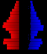
Demographics
Census
A census is the procedure of systematically acquiring and recording information about the members of a given population. It is a regularly occurring and official count of a particular population. The term is used mostly in connection with national population and housing censuses; other common...
of 2000, there were 6,885 people, 2,633 households, and 1,958 families residing in the county. The population density
Population density
Population density is a measurement of population per unit area or unit volume. It is frequently applied to living organisms, and particularly to humans...
was 9 people per square mile (3/km²). There were 3,033 housing units at an average density of 4 per square mile (1/km²). The racial makeup of the county was 97.24% White
Race (United States Census)
Race and ethnicity in the United States Census, as defined by the Federal Office of Management and Budget and the United States Census Bureau, are self-identification data items in which residents choose the race or races with which they most closely identify, and indicate whether or not they are...
, 0.46% Black
Race (United States Census)
Race and ethnicity in the United States Census, as defined by the Federal Office of Management and Budget and the United States Census Bureau, are self-identification data items in which residents choose the race or races with which they most closely identify, and indicate whether or not they are...
or African American
Race (United States Census)
Race and ethnicity in the United States Census, as defined by the Federal Office of Management and Budget and the United States Census Bureau, are self-identification data items in which residents choose the race or races with which they most closely identify, and indicate whether or not they are...
, 0.49% Native American
Race (United States Census)
Race and ethnicity in the United States Census, as defined by the Federal Office of Management and Budget and the United States Census Bureau, are self-identification data items in which residents choose the race or races with which they most closely identify, and indicate whether or not they are...
, 0.15% Asian
Race (United States Census)
Race and ethnicity in the United States Census, as defined by the Federal Office of Management and Budget and the United States Census Bureau, are self-identification data items in which residents choose the race or races with which they most closely identify, and indicate whether or not they are...
, 0.06% Pacific Islander
Race (United States Census)
Race and ethnicity in the United States Census, as defined by the Federal Office of Management and Budget and the United States Census Bureau, are self-identification data items in which residents choose the race or races with which they most closely identify, and indicate whether or not they are...
, 0.60% from other races
Race (United States Census)
Race and ethnicity in the United States Census, as defined by the Federal Office of Management and Budget and the United States Census Bureau, are self-identification data items in which residents choose the race or races with which they most closely identify, and indicate whether or not they are...
, and 1.00% from two or more races. 1.86% of the population were Hispanic
Race (United States Census)
Race and ethnicity in the United States Census, as defined by the Federal Office of Management and Budget and the United States Census Bureau, are self-identification data items in which residents choose the race or races with which they most closely identify, and indicate whether or not they are...
or Latino
Race (United States Census)
Race and ethnicity in the United States Census, as defined by the Federal Office of Management and Budget and the United States Census Bureau, are self-identification data items in which residents choose the race or races with which they most closely identify, and indicate whether or not they are...
of any race.
There were 2,633 households out of which 33.50% had children under the age of 18 living with them, 64.30% were married couples
Marriage
Marriage is a social union or legal contract between people that creates kinship. It is an institution in which interpersonal relationships, usually intimate and sexual, are acknowledged in a variety of ways, depending on the culture or subculture in which it is found...
living together, 6.30% had a female householder with no husband present, and 25.60% were non-families. 23.00% of all households were made up of individuals and 10.80% had someone living alone who was 65 years of age or older. The average household size was 2.57 and the average family size was 3.01.
In the county the population was spread out with 26.70% under the age of 18, 6.20% from 18 to 24, 26.70% from 25 to 44, 24.80% from 45 to 64, and 15.60% who were 65 years of age or older. The median age was 40 years. For every 100 females there were 102.50 males. For every 100 females age 18 and over, there were 101.30 males.
The median income for a household in the county was $41,710, and the median income for a family was $47,500. Males had a median income of $31,629 versus $23,148 for females. The per capita income
Per capita income
Per capita income or income per person is a measure of mean income within an economic aggregate, such as a country or city. It is calculated by taking a measure of all sources of income in the aggregate and dividing it by the total population...
for the county was $17,704. About 5.80% of families and 7.30% of the population were below the poverty line, including 8.40% of those under age 18 and 7.90% of those age 65 or over.
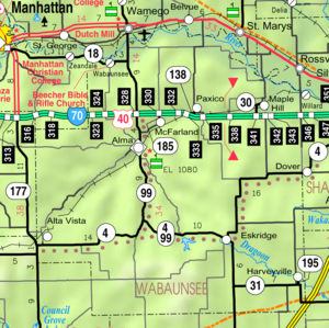
Incorporated cities
Name and population (2004 estimate):- AlmaAlma, KansasAlma is a city in and the county seat of Wabaunsee County, Kansas, United States. As of the 2010 census, the city population was 832. Alma is part of the Topeka, Kansas Metropolitan Statistical Area.-History:...
, 768 (county seat) - EskridgeEskridge, KansasEskridge is a city in Wabaunsee County, Kansas, United States. The population was 589 at the 2000 census. It is part of the Topeka, Kansas Metropolitan Statistical Area.-History:...
, 579 - Maple HillMaple Hill, KansasMaple Hill is a city in Wabaunsee County, Kansas, United States. The population was 469 at the 2000 census. It is part of the Topeka, Kansas Metropolitan Statistical Area.-History:...
, 491 - Alta VistaAlta Vista, KansasAlta Vista is a city in Wabaunsee County, Kansas, United States. The population was 442 at the 2000 census. It is part of the Topeka, Kansas Metropolitan Statistical Area.-History:...
, 431 - McFarlandMcFarland, KansasMcFarland is a city in Wabaunsee County, Kansas, United States. The population was 271 at the 2000 census. It is part of the Topeka, Kansas Metropolitan Statistical Area.-History:...
, 268 - HarveyvilleHarveyville, KansasHarveyville is a city in Wabaunsee County, Kansas, United States. The population was 267 at the 2000 census. Harveyville is part of the Topeka, Kansas Metropolitan Statistical Area.-Geography:Harveyville is located at...
, 256 - PaxicoPaxico, KansasPaxico is a city in Wabaunsee County, Kansas, United States. The population was 211 at the 2000 census. It is part of the Topeka, Kansas Metropolitan Statistical Area.-History:...
, 215 - WillardWillard, KansasWillard is a city in Shawnee and Wabaunsee counties in the U.S. state of Kansas. The population was 86 at the 2000 census. It is part of the Topeka, Kansas Metropolitan Statistical Area.-History:...
, 84 (Small portion of corporate limits extends into Wabaunsee Co.) - St. MarysSt. Marys, KansasSt. Marys is a city in Pottawatomie and Wabaunsee counties in the U.S. state of Kansas, approximately 20 miles west of Topeka on U.S. Route 24. The population was 2,198 at the 2000 census. It is part of the Manhattan, Kansas Metropolitan Statistical Area....
(Small portion of corporate limits extends into Wabaunsee Co.)
Townships
Wabaunsee County is divided into thirteen townshipsCivil township
A civil township is a widely used unit of local government in the United States, subordinate to, and geographic divisions of, a county. Specific responsibilities and the degree of autonomy vary based on each state. Civil townships are distinct from survey townships, but in states that have both,...
. None of the cities within the county are considered governmentally independent, and all figures for the townships include those of the cities. In the following table, the population center is the largest city (or cities) included in that township's population total, if it is of a significant size.
| Township | FIPS | Population center |
Population | Population density /km² (/sq mi) |
Land area km² (sq mi) | Water area km² (sq mi) | Water % | Geographic coordinates |
|---|---|---|---|---|---|---|---|---|
| Alma | 01375 | 1,137 | 11 (28) | 104 (40) | 0 (0) | 0 % | 39°1′8"N 96°17′33"W | |
| Farmer | 23125 | 119 | 1 (2) | 172 (66) | 0 (0) | 0.07% | 38°55′37"N 96°18′44"W | |
| Garfield | 25850 | 590 | 5 (13) | 118 (45) | 0 (0) | 0.09% | 38°51′44"N 96°27′20"W | |
| Kaw | 36150 | 242 | 2 (6) | 110 (42) | 2 (1) | 1.55% | 39°10′16"N 96°9′46"W | |
| Maple Hill | 44525 | 930 | 5 (13) | 190 (73) | 1 (0) | 0.55% | 39°4′43"N 96°0′52"W | |
| Mill Creek | 46725 | 293 | 2 (4) | 192 (74) | 1 (0) | 0.43% | 38°53′23"N 96°11′23"W | |
| Mission Creek | 47300 | 495 | 2 (6) | 209 (81) | 0 (0) | 0.04% | 38°55′49"N 96°3′0"W | |
| Newbury | 50275 | 1,045 | 5 (13) | 203 (78) | 0 (0) | 0.06% | 39°3′44"N 96°11′18"W | |
| Plumb | 56800 | 640 | 5 (13) | 129 (50) | 0 (0) | 0.17% | 38°47′56"N 95°58′36"W | |
| Rock Creek | 60650 | 84 | 0 (1) | 171 (66) | 0 (0) | 0.05% | 38°46′58"N 96°18′15"W | |
| Wabaunsee | 74250 | 455 | 3 (7) | 172 (66) | 2 (1) | 1.05% | 39°6′57"N 96°18′21"W | |
| Washington | 75800 | 83 | 1 (1) | 148 (57) | 0 (0) | 0.02% | 38°57′49"N 96°25′14"W | |
| Wilmington | 79525 | 772 | 5 (13) | 150 (58) | 0 (0) | 0.03% | 38°49′54"N 96°6′14"W |
Education
Unified school districts
See also
- National Register of Historic Places listings in Wabaunsee County, KansasNational Register of Historic Places listings in Wabaunsee County, KansasThis is a list of the National Register of Historic Places listings in Wabaunsee County, Kansas.This is intended to be a complete list of the properties and districts on the National Register of Historic Places in Wabaunsee County, Kansas, United States...
Further reading
- History of the State of Kansas; William G. Cutler; A.T. Andreas Publisher; 1883. (Online HTML eBook)
- Kansas : A Cyclopedia of State History, Embracing Events, Institutions, Industries, Counties, Cities, Towns, Prominent Persons, Etc; 3 Volumes; Frank W. Blackmar; Standard Publishing Co; 944 / 955 / 824 pages; 1912. (Volume1 - Download 54MB PDF eBook),(Volume2 - Download 53MB PDF eBook), (Volume3 - Download 33MB PDF eBook)
External links
OfficialGeneral Information
Kansas County Data
Wabaunsee County local history and genealogy
- Kansas State Historical Society
- William G. Cutler's History of the State of Kansas
- Wabaunsee County GenWeb website
- Wabaunsee County history, including Underground Railroad stations
Maps
- Wabaunsee County Map, KDOT
- Kansas Highway Map, KDOT
- Kansas Railroad Map, KDOT
- Kansas School District Boundary Map, KSDE