Wadi Al Shatii
Encyclopedia
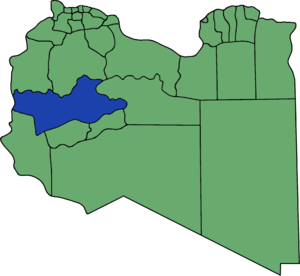
Wadi al Shatii sometimes referred to as Ash Shati ( Aš Šāṭi' ), is one of the districts of Libya
in the central-west part of the country. Its capital is Brak. The area is mostly desert.
To the west, Wadi al Shatii borders the Illizi Province
of Algeria
. After the 2007 administrative reorganization of districts, it borders on the following districts:
Wadi Al Shatii District is named after the depression (former lakebed) of the same name, Wadi ash-Shati'
. The depression extends east from the town of Umm al-'Abid to the town of Wanzarik on the west, a distance of about 87 miles (140 km).
 In 1943, very large, but low grade, sedimentary iron-ore deposits were discovered in the Wadi al Shatii District near Brak. Economically, it is only suitable for strip mining. There are also potential economic manganese
deposits in the same area. The manganese occurs in lens or veinlets (up to 23% Mg) in the sandstones associated with the iron ore. Millet
is the primary agricultural export from the valley.
Libya
Libya is an African country in the Maghreb region of North Africa bordered by the Mediterranean Sea to the north, Egypt to the east, Sudan to the southeast, Chad and Niger to the south, and Algeria and Tunisia to the west....
in the central-west part of the country. Its capital is Brak. The area is mostly desert.
To the west, Wadi al Shatii borders the Illizi Province
Illizi Province
Illizi is a province in the south-eastern corner of Algeria named after its eponymous seat.It borders Libya to the east, Ouargla Province to the north and, Tamanghasset Province to the east and south.-Administrative divisions:...
of Algeria
Algeria
Algeria , officially the People's Democratic Republic of Algeria , also formally referred to as the Democratic and Popular Republic of Algeria, is a country in the Maghreb region of Northwest Africa with Algiers as its capital.In terms of land area, it is the largest country in Africa and the Arab...
. After the 2007 administrative reorganization of districts, it borders on the following districts:
- Nalut - northwest
- Al Jabal al GharbiAl Jabal al Gharbi DistrictJabal al Gharbi is one of the districts of Libya. It was formed in 2007 from the former districts of Yafran, Gharyan and Mizda. From 1995 to 1998 Jabal al Gharbi also existed as a Baladiyah.Jabal al Gharbi borders the following districts:...
- north - Al Jufrah - east
- Sabha - southeast
- Wadi Al Hayaa - south
- Ghat - southwest
Wadi Al Shatii District is named after the depression (former lakebed) of the same name, Wadi ash-Shati'
Wadi ash-Shati'
The Wadi ash-Shati is a valley in west-central Libya, arising out of the Sawda Mountains, situated between the towns Wanzarik and Umm al-'Abid in the west and east, respectively. It is known for iron ore and manganese deposits....
. The depression extends east from the town of Umm al-'Abid to the town of Wanzarik on the west, a distance of about 87 miles (140 km).
Economy

Manganese
Manganese is a chemical element, designated by the symbol Mn. It has the atomic number 25. It is found as a free element in nature , and in many minerals...
deposits in the same area. The manganese occurs in lens or veinlets (up to 23% Mg) in the sandstones associated with the iron ore. Millet
Millet
The millets are a group of small-seeded species of cereal crops or grains, widely grown around the world for food and fodder. They do not form a taxonomic group, but rather a functional or agronomic one. Their essential similarities are that they are small-seeded grasses grown in difficult...
is the primary agricultural export from the valley.

