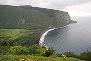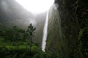
Waipio valley
Encyclopedia


Hamakua
thumb|right|280px|Districts of [[Hawaii |Hawaii island]]: from northernmost, clockwise; [[Kohala, Hawaii|Kohala]], Hāmākua , [[Hilo, Hawaii|Hilo]], [[Puna, Hawaii|Puna]], [[Kau, Hawaii|Kaū]], [[Kona District, Hawaii|Kona]]...
District of the Big Island
Hawaii (island)
The Island of Hawaii, also called the Big Island or Hawaii Island , is a volcanic island in the North Pacific Ocean...
of Hawaii
Hawaii
Hawaii is the newest of the 50 U.S. states , and is the only U.S. state made up entirely of islands. It is the northernmost island group in Polynesia, occupying most of an archipelago in the central Pacific Ocean, southwest of the continental United States, southeast of Japan, and northeast of...
. "Waipio" means "curved water" in the Hawaiian language
Hawaiian language
The Hawaiian language is a Polynesian language that takes its name from Hawaii, the largest island in the tropical North Pacific archipelago where it developed. Hawaiian, along with English, is an official language of the state of Hawaii...
.
It was the capital and permanent residence of many early Hawaiian alii
Ali'i
Alii is a word in the Polynesian language denoting chiefly status in ancient Hawaii and the Samoa Islands. A similar word with the same concept is found in other Polynesian societies. In the Cook Islands, an ariki is a high chief and the House of Ariki is a parliamentary house...
(kings) up until the time of King Umi
'Umi-a-Liloa
Umi-a-Liloa ruled as the 14th Alii Aimoku of Hawaii island from 1510 to 1525.-Royal Birth:Umi-a-Liloa, commonly known as Umi, was younger son of Liloa, 12th Alii Aimoku of Hawaii. Umi's mother Akahiakuleana was of much lower rank and distantly related to Liloa...
. A place celebrated for its nioi tree (Eugenia reinwardtiana) known as the "Nioi wela o Paakalana" (The burning Nioi of Paakalana). It was the location of the ancient grass palace of the ancient kings of Hawaii with the nioi stands. Kahekili II
Kahekili II
Kahekili II, full name Kahekilinuiahumanu, was the twenty fifth King of Maui. His name was short for Kāne-Hekili after the Hawaiian god of thunder. Because Kāne-Hekili was believed to be black on one side, Kahekili tattooed one side of his body from head to foot.-Family:He was born about...
raided Waipio in the 18th century and burned the four sacred trees to the ground.
Located at coordinates 20°7′11"N 155°35′36"W, the valley floor at sea level is almost 2000 ft (609.6 m) below the surrounding terrain. A steep road leads down into the valley from a lookout point located on the top of the southern wall of the valley. The road gains 800 vertical feet (243.84 m) in 0.6 miles (0.9 km) at a 25% average grade, with steeper grades in sections. This is a paved public road but it is open only to 4 wheel drive vehicles. If classified as a road, it would be the steepest road of its length in the United States and possibly the world. The shore line in the valley is a black sand
Black sand
Black sand is sand that is black in color. One type of black sand is a heavy, glossy, partly magnetic mixture of usually fine sands, found as part of a placer deposit. Another type of black sand, found on beaches near a volcano, consists of tiny fragments of lava.While some beaches are...
beach, popular with surfers
Surfing
Surfing' is a surface water sport in which the surfer rides a surfboard on the crest and face of a wave which is carrying the surfer towards the shore...
. A few taro
Taro
Taro is a common name for the corms and tubers of several plants in the family Araceae . Of these, Colocasia esculenta is the most widely cultivated, and is the subject of this article. More specifically, this article describes the 'dasheen' form of taro; another variety is called eddoe.Taro is...
farms are located in the valley.
Several large waterfalls fall into the valley to feed the river which flows from the foot of the largest falls at the back of the valley out to the ocean.
The valley was the site of the final scene in the 1995 sci-fi film Waterworld
Waterworld
Waterworld is a 1995 post-apocalyptic science fiction film. The film was directed by Kevin Reynolds and co-written by Peter Rader and David Twohy. It is based on Rader's original 1986 screenplay and stars Kevin Costner, who also produced it. It was distributed by Universal Pictures...
, at which the main characters found dry land.

