

Wardour Street
Encyclopedia

Soho
Soho is an area of the City of Westminster and part of the West End of London. Long established as an entertainment district, for much of the 20th century Soho had a reputation for sex shops as well as night life and film industry. Since the early 1980s, the area has undergone considerable...
, London. It is a one-way street south to north from Leicester Square
Leicester Square
Leicester Square is a pedestrianised square in the West End of London, England. The Square lies within an area bound by Lisle Street, to the north; Charing Cross Road, to the east; Orange Street, to the south; and Whitcomb Street, to the west...
, up through Chinatown
Chinatown, London
The name Chinatown has been used at different times to describe different places in London. The present Chinatown is part of the Soho area of the City of Westminster, occupying the area in and around Gerrard Street...
, across Shaftesbury Avenue
Shaftesbury Avenue
Shaftesbury Avenue is a major street in central London, England, named after Anthony Ashley Cooper, 7th Earl of Shaftesbury, that runs in a north-easterly direction from Piccadilly Circus to New Oxford Street, crossing Charing Cross Road at Cambridge Circus....
to Oxford Street
Oxford Street
Oxford Street is a major thoroughfare in the City of Westminster in the West End of London, United Kingdom. It is Europe's busiest shopping street, as well as its most dense, and currently has approximately 300 shops. The street was formerly part of the London-Oxford road which began at Newgate,...
.
History
It is named after Sir Archibald Wardour, who was the architect of several buildings on the street. There has been a thoroughfare here on maps and plans since they were first printed, the earliest being Elizabethan.In 1585, to settle a legal dispute, a plan of what is now the West End was prepared. The dispute was about a field roughly where Broadwick Street is today. The plan was very accurate and clearly gives the name Colmanhedge Lane to this major route across the fields described as “The Waye from Vxbridge to London” (Oxford St) to what is now Cockspur St. The old plan shows that this lane follows the modern road almost exactly, including bends at Brewer and Old Compton Streets.
The road is also a major thoroughfare on Faithorne and Newcourt’s map surveyed between 1643 and 1647. Although they do not give a name, it has about 24 houses and a large “Gaming House” roughly on the site of the Odeon cinema on the north west corner of Leicester Square
Leicester Square
Leicester Square is a pedestrianised square in the West End of London, England. The Square lies within an area bound by Lisle Street, to the north; Charing Cross Road, to the east; Orange Street, to the south; and Whitcomb Street, to the west...
. The map also shows a large windmill, 40-50 yards to the west of what is now the Church of St Anne, roughly on the current position of Great Windmill Street.
The name Colmanhedge Lane did not last and a 1682 map by Ogilby and Morgan shows the lane split into three parts. The northern part is shown as SO HO, the middle part Whitcomb St and the remainder from James St south, is Hedge Lane. It is not clear from the map where the boundary between SO HO and Whitcombe St is, probably somewhere between Compton Street and Gerrard St. These three names are on the Morden and Lea map of 1682.
John Rocque shows the road very clearly on his large scale map of 1746, however the names have changed again. From Oxford St south to Meard St
Meard Street
Meard Street in a street in Soho, London. It runs roughly East-West , between Wardour Street to the west and Dean Street to the east...
is now Wardour Street. Then south to Compton Street is Old Soho; then down to Coventry St is Princes Street. For the length of Leicester Square is Whicomb St and finally Hedge Lane which now starts at Panton St rather than James Street
James Street
- People :* James Street , American football quarterback* James H. Street , American journalist, Baptist minister, and novelist* James Street , English cricketer and umpire- Places :...
.
By the end of the 18th century Horwood, on a large map of 1799, uses the same names but not Old Soho and Hedge Lane. This leaves just Wardour, Princess and Whitcomb streets. The houses have individual numbers by then and are shown in detail on Horwood’s map.
The names are much the same on Greenwood’s map of 1827 although the area at the southern end had been re-developed. The road now ends at Pall Mall
Pall Mall, London
Pall Mall is a street in the City of Westminster, London, and parallel to The Mall, from St. James's Street across Waterloo Place to the Haymarket; while Pall Mall East continues into Trafalgar Square. The street is a major thoroughfare in the St James's area of London, and a section of the...
East, and the boundary between Wardour and Princes St may have moved north a little.
By 1846, Cruchley’s new plan of London shows change at the southern end. Wardour, Princes and Whitcomb streets stay the same but Whitcomb Street loses a few hundred yards at the southern end and, from James Street to Pall Mall, is now Dorset Place.
In Victorian times Princes Street is still shown on the 1871 Ordnance Survey
Ordnance Survey
Ordnance Survey , an executive agency and non-ministerial government department of the Government of the United Kingdom, is the national mapping agency for Great Britain, producing maps of Great Britain , and one of the world's largest producers of maps.The name reflects its creation together with...
map. Stanford’s Map of Central London 1897, at 6” to a mile, has just two names, Wardour Street from Oxford Street to Coventry St and Whitcomb St south from there. It has remained this since, though numbering was rationalised around 1896.
In the late 19th century, Wardour Street was known for slightly shoddy furniture stores. Wardour Street prose implies the use of near-obsolete words for effect, such as anent, which refers to a large number of antique shops in the area.
20th century
During this period, it became a centre of the British film industryCinema of the United Kingdom
The United Kingdom has had a major influence on modern cinema. The first moving pictures developed on celluloid film were made in Hyde Park, London in 1889 by William Friese Greene, a British inventor, who patented the process in 1890. It is generally regarded that the British film industry...
, with the big production and distribution
Film distributor
A film distributor is a company or individual responsible for releasing films to the public either theatrically or for home viewing...
companies having their headquarters in the street. By the end of the century most of the big film companies had moved elsewhere, leaving some smaller independent production houses and post-production
Post-production
Post-production is part of filmmaking and the video production process. It occurs in the making of motion pictures, television programs, radio programs, advertising, audio recordings, photography, and digital art...
companies still based in the area.
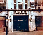
Number 90 was the site of the Marquee Club
Marquee Club
The Marquee was a music club first located at 165 Oxford Street, London, England when it opened in 1958 with a range of jazz and skiffle acts.It was also the location of the first ever live performance by The Rolling Stones on 12 July 1962....
from 1964 to 1988 and is mentioned in the title of a song by The Jam
The Jam
The Jam were an English punk rock/New Wave/mod revival band active during the late 1970s and early 1980s. They were formed in Woking, Surrey. While they shared the "angry young men" outlook and fast tempos of their punk rock contemporaries, The Jam wore smartly tailored suits rather than ripped...
, "A-Bomb in Wardour Street". It is also mentioned in the song "The London Boys" by David Bowie and in the spoken introduction to Long John Baldry's
Long John Baldry
John William "Long John" Baldry was an English and Canadian blues singer and a voice actor. He sang with many British musicians, with Rod Stewart and Elton John appearing in bands led by Baldry in the 1960s. He enjoyed pop success in the UK where Let the Heartaches Begin reached No...
"Don't Try to Lay No Boogie Woogie on the King of Rock and Roll". In 1985, "90 Wardour Street" was also the title of the 1st LP by NY based garage-pop band Mod Fun
Mod Fun
Mod Fun are an American power pop/garage punk band from the New York City area. Mod Fun were originally active in the early to mid 1980s, and played an integral part in New York City's burgeoning garage rock revival scene of the time. By mid 1986 they were widely regarded as one the best known...
. It is now home to a restaurant and bar called Floridita and above it Soho Lofts, an exclusive block of flats. The Underworld
Underworld (band)
Underworld are a British electronic group, and principal name under which duo Karl Hyde and Rick Smith have recorded together since 1980.- Early years: 1979–1986 :...
song Stagger includes the lyric "I found you shopping in Europa on Wardour Street". A branch of the supermarket Europa was at number 178, which is now a branch of the Ryman
Ryman
Ryman is the largest British stationery retailer, historically based in London, now based in its £100m headquarters in Crewe, Cheshire.-Formation:...
stationers' chain.
21st century
The street is home to over 30 restaurants and bars north of Shaftesbury Avenue. South of Shaftesbury Avenue there are lots of well-known Chinese restaurants including the large Wong KeiWong Kei
Wong Kei is a Chinese restaurant in London's Chinatown. It is one of the largest Chinese restaurants in the UK with seating for around 500 diners.-Building:...
at no. 41-43.
The street crosses, or meets with, Lisle Street, Gerrard Street
Gerrard Street
There are several streets called Gerrard Street, including:*Gerrard Street in London, United Kingdom.*Gerrard Street in Toronto, Canada....
, Rupert Court, Dansey Place, Shaftesbury Avenue
Shaftesbury Avenue
Shaftesbury Avenue is a major street in central London, England, named after Anthony Ashley Cooper, 7th Earl of Shaftesbury, that runs in a north-easterly direction from Piccadilly Circus to New Oxford Street, crossing Charing Cross Road at Cambridge Circus....
, Winette Street, Tisbury Court, Old Compton Street
Old Compton Street
Old Compton Street runs east-west through Soho, London, England.- History :The street was named after Henry Compton. who raised funds for a local parish church, eventually dedicated as St Anne's Church in 1686...
, Brewer Street
Brewer Street
Brewer Street is a street in the Soho area of central London, England, running west to east from Glasshouse Street to Wardour Street. It was first developed in the late 17th century by the landowner, Sir William Pulteney. It first appears on a map of 1664, and was built up over the following...
, Bouchier Street, Peter Street, Tyler's Court, Flaxman Court, Broadwick Street
Broadwick Street
Broadwick Street is a street in Soho, City of Westminster, London. It runs for 0.18 mile approximately west-east between Marshall Street and Wardour Street, crossing Berwick Street....
, St Anne's Court, Sheraton Street, D'Arblay Street, Hollen Street, Noel Street and Oxford Street
Oxford Street
Oxford Street is a major thoroughfare in the City of Westminster in the West End of London, United Kingdom. It is Europe's busiest shopping street, as well as its most dense, and currently has approximately 300 shops. The street was formerly part of the London-Oxford road which began at Newgate,...
.
External links
- LondonTown.com information
- Wardour Street (east side) and Wardour Street (west side)
- The Bristow v Wilson Lawsuit 1585 National Archives (Kew) Item MPB 1/1
- Ogilby and Morgan 1647 http://www.british-history.ac.uk/lmap.asp?compid=22025&slice=774&buffer=1#iframe
- Morden & Lea 1682 British Library Crace Collection: Maps Crace Port.2 60.
- John Stow (John StrypeJohn StrypeJohn Strype was an English historian and biographer. He was a cousin of Robert Knox, a famous sailor.Born in Houndsditch, London, he was the son of John Strype, or van Stryp, a member of a Huguenot family whom, in order to escape religious persecution within Brabant, had settled in East London...
, editor) 1720 http://www.oldlondonmaps.com/stowpages/martinfield.html - John Rocque 1746 http://www.motco.com/map/81002/
- Horwood 1799 http://www.oldlondonmaps.com/horwoodpages/horwoodmain.html
- The London Directory, Printed for Wilkinson .R 1811 http://www.oldlondonmaps.com/1811pages/1811MAIN.html
- Greenwood 1827 http://www.motco.com/map/81003/
- Cruchley's New Plan of London 1827 http://archivemaps.com/mapco/cruchley/cruch11.htm
- Stanford 1872 http://www.oldlondonmaps.com/stanfordpages/westminster03b.html
- Stanford 1897 http://archivemaps.com/mapco/stanford/stan33.htm
- Hummus Bros has a branch on Wardour Street http://www.hbros.co.uk/soho/