Warm front
Encyclopedia
A warm front is a density discontinuity
located at the leading edge of a homogeneous warm air mass
, and is typically located on the equator-facing edge of an isotherm gradient. Warm fronts lie within broader troughs of low pressure than cold fronts, and move more slowly than the cold fronts which usually follow because cold air is denser and less easier to remove from the Earth's surface. This also forces temperature differences across warm fronts to be broader in scale.
Clouds ahead of the warm front are mostly stratiform
, and rainfall gradually increases as the front approaches. Fog
can also occur preceding a warm frontal passage. Clearing and warming is usually rapid after frontal passage. If the warm air mass is unstable, thunderstorms may be embedded among the stratiform clouds ahead of the front, and after frontal passage thundershowers may continue. On weather maps
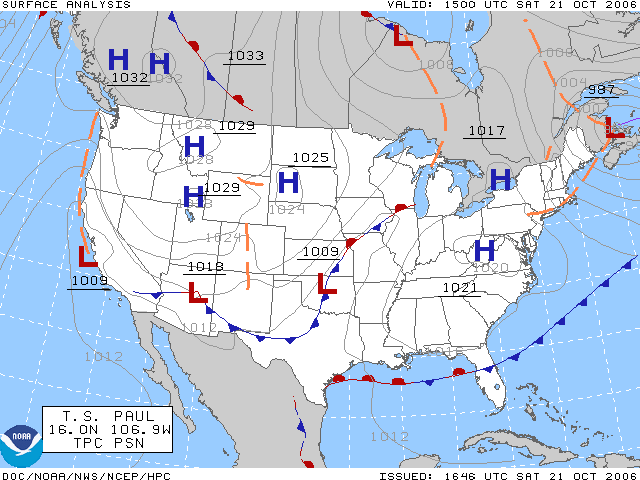
, the surface location of a warm front is marked with a red line of semicircles pointing in the direction of travel.

Air masses are large bodies of air with similar properties of temperature
and humidity
that form over source regions, and the warm air masses behind warm fronts are not only warmer but higher in humidity than the colder air preceding them. Because of a warm air mass’s higher temperature and thus lesser density
, mixing between the two air masses is unlikely. Being lighter, the warm air mass is unable to displace the cooler air mass and instead is forced upward along the upper boundary of the colder air in a process known as overrunning. The boundary between the two air masses has a gradual slope of 130 and lifting is slow but persistent.
As the air mass rises into regions of lower pressure, it expands and cools. As it cools, water vapor
condenses
and forms extensive cloud
coverage. The first clouds to form along the sloping surface of the cold air are high cirrus, which thicken to cirrostratus and altostratus. Once the clouds have thickened to 2500 metres (8,202.1 ft) from the earth’s surface, rain can begin to fall from the heavy nimbostratus cloud.
. Once the front passes, the location experiences some warming and clearing. If the air mass
is unstable, and the warm front is an anafront, thunderstorm
s may precede and follow the front and temperature changes will be larger.
In the northern hemisphere
, a warm front causes a shift of wind
blowing from southeast to southwest, and in the southern hemisphere
a shift from winds blowing from northeast to northwest. Common characteristics associated with warm fronts include:
s in a depression. Temperatures are often warmer than they are before the warm front or after the cold front. Cloud types can be mixed, but usually consist of stratocumulus, which can range to being broken to covering the entire sky depending on distance from the centre of low pressure.
 On weather map
s, the surface location of a warm front is marked with a red line of half circles pointing in the direction of the front. On colored weather maps, warm fronts are illustrated with a solid red line.
Weather front
A weather front is a boundary separating two masses of air of different densities, and is the principal cause of meteorological phenomena. In surface weather analyses, fronts are depicted using various colored lines and symbols, depending on the type of front...
located at the leading edge of a homogeneous warm air mass
Air mass
In meteorology, an air mass is a volume of air defined by its temperature and water vapor content. Air masses cover many hundreds or thousands of square miles, and adopt the characteristics of the surface below them. They are classified according to latitude and their continental or maritime...
, and is typically located on the equator-facing edge of an isotherm gradient. Warm fronts lie within broader troughs of low pressure than cold fronts, and move more slowly than the cold fronts which usually follow because cold air is denser and less easier to remove from the Earth's surface. This also forces temperature differences across warm fronts to be broader in scale.
Clouds ahead of the warm front are mostly stratiform
Stratus cloud
A stratus cloud is a cloud belonging to a class characterized by horizontal layering with a uniform base, as opposed to convective clouds that are as tall or taller than wide . More specifically, the term stratus is used to describe flat, hazy, featureless clouds of low altitude varying in color...
, and rainfall gradually increases as the front approaches. Fog
Fog
Fog is a collection of water droplets or ice crystals suspended in the air at or near the Earth's surface. While fog is a type of stratus cloud, the term "fog" is typically distinguished from the more generic term "cloud" in that fog is low-lying, and the moisture in the fog is often generated...
can also occur preceding a warm frontal passage. Clearing and warming is usually rapid after frontal passage. If the warm air mass is unstable, thunderstorms may be embedded among the stratiform clouds ahead of the front, and after frontal passage thundershowers may continue. On weather maps
Surface weather analysis
Surface weather analysis is a special type of weather map that provides a view of weather elements over a geographical area at a specified time based on information from ground-based weather stations...
, the surface location of a warm front is marked with a red line of semicircles pointing in the direction of travel.
Development

Air masses are large bodies of air with similar properties of temperature
Temperature
Temperature is a physical property of matter that quantitatively expresses the common notions of hot and cold. Objects of low temperature are cold, while various degrees of higher temperatures are referred to as warm or hot...
and humidity
Humidity
Humidity is a term for the amount of water vapor in the air, and can refer to any one of several measurements of humidity. Formally, humid air is not "moist air" but a mixture of water vapor and other constituents of air, and humidity is defined in terms of the water content of this mixture,...
that form over source regions, and the warm air masses behind warm fronts are not only warmer but higher in humidity than the colder air preceding them. Because of a warm air mass’s higher temperature and thus lesser density
Density
The mass density or density of a material is defined as its mass per unit volume. The symbol most often used for density is ρ . In some cases , density is also defined as its weight per unit volume; although, this quantity is more properly called specific weight...
, mixing between the two air masses is unlikely. Being lighter, the warm air mass is unable to displace the cooler air mass and instead is forced upward along the upper boundary of the colder air in a process known as overrunning. The boundary between the two air masses has a gradual slope of 130 and lifting is slow but persistent.
As the air mass rises into regions of lower pressure, it expands and cools. As it cools, water vapor
Water vapor
Water vapor or water vapour , also aqueous vapor, is the gas phase of water. It is one state of water within the hydrosphere. Water vapor can be produced from the evaporation or boiling of liquid water or from the sublimation of ice. Under typical atmospheric conditions, water vapor is continuously...
condenses
Condensation
Condensation is the change of the physical state of matter from gaseous phase into liquid phase, and is the reverse of vaporization. When the transition happens from the gaseous phase into the solid phase directly, the change is called deposition....
and forms extensive cloud
Cloud
A cloud is a visible mass of liquid droplets or frozen crystals made of water and/or various chemicals suspended in the atmosphere above the surface of a planetary body. They are also known as aerosols. Clouds in Earth's atmosphere are studied in the cloud physics branch of meteorology...
coverage. The first clouds to form along the sloping surface of the cold air are high cirrus, which thicken to cirrostratus and altostratus. Once the clouds have thickened to 2500 metres (8,202.1 ft) from the earth’s surface, rain can begin to fall from the heavy nimbostratus cloud.
Characteristics
If the air mass is relatively stable, and the warm front is a katafront, rainfall will increase until the front reaches the location, at which time the clouds can extend all the way to the earth’s surface as fogFog
Fog is a collection of water droplets or ice crystals suspended in the air at or near the Earth's surface. While fog is a type of stratus cloud, the term "fog" is typically distinguished from the more generic term "cloud" in that fog is low-lying, and the moisture in the fog is often generated...
. Once the front passes, the location experiences some warming and clearing. If the air mass
Air mass
In meteorology, an air mass is a volume of air defined by its temperature and water vapor content. Air masses cover many hundreds or thousands of square miles, and adopt the characteristics of the surface below them. They are classified according to latitude and their continental or maritime...
is unstable, and the warm front is an anafront, thunderstorm
Thunderstorm
A thunderstorm, also known as an electrical storm, a lightning storm, thundershower or simply a storm is a form of weather characterized by the presence of lightning and its acoustic effect on the Earth's atmosphere known as thunder. The meteorologically assigned cloud type associated with the...
s may precede and follow the front and temperature changes will be larger.
In the northern hemisphere
Northern Hemisphere
The Northern Hemisphere is the half of a planet that is north of its equator—the word hemisphere literally means “half sphere”. It is also that half of the celestial sphere north of the celestial equator...
, a warm front causes a shift of wind
Wind
Wind is the flow of gases on a large scale. On Earth, wind consists of the bulk movement of air. In outer space, solar wind is the movement of gases or charged particles from the sun through space, while planetary wind is the outgassing of light chemical elements from a planet's atmosphere into space...
blowing from southeast to southwest, and in the southern hemisphere
Southern Hemisphere
The Southern Hemisphere is the part of Earth that lies south of the equator. The word hemisphere literally means 'half ball' or "half sphere"...
a shift from winds blowing from northeast to northwest. Common characteristics associated with warm fronts include:
| Weather phenomenon | Prior to the Passing of the Front | While the Front is Passing | After the Passing of the Front |
|---|---|---|---|
| Temperature | Cool | Warming suddenly | Warmer, then leveling off |
| Atmospheric pressure | Decreasing steadily | Leveling off | Slight rise followed by a decrease |
| Winds |
|
Variable |
|
| Precipitation | Showers, snow Snow Snow is a form of precipitation within the Earth's atmosphere in the form of crystalline water ice, consisting of a multitude of snowflakes that fall from clouds. Since snow is composed of small ice particles, it is a granular material. It has an open and therefore soft structure, unless packed by... , sleet Rain and snow mixed Rain and snow mixed is precipitation composed of rain and partially melted snow. This precipitation can occur where the temperature in the lower part of the atmosphere is slightly above the freezing point... , or drizzle Rain Rain is liquid precipitation, as opposed to non-liquid kinds of precipitation such as snow, hail and sleet. Rain requires the presence of a thick layer of the atmosphere to have temperatures above the melting point of water near and above the Earth's surface... |
Light drizzle | Usually none, sometimes light rain or showers |
| Clouds | cirrus Cirrus cloud Cirrus clouds are atmospheric clouds generally characterized by thin, wispy strands, giving them their name from the Latin word cirrus meaning a ringlet or curling lock of hair... , cirrostratus, altostratus, nimbostratus, then stratus Stratus cloud A stratus cloud is a cloud belonging to a class characterized by horizontal layering with a uniform base, as opposed to convective clouds that are as tall or taller than wide . More specifically, the term stratus is used to describe flat, hazy, featureless clouds of low altitude varying in color... (pilots use the acronym CCANS) and fog Fog Fog is a collection of water droplets or ice crystals suspended in the air at or near the Earth's surface. While fog is a type of stratus cloud, the term "fog" is typically distinguished from the more generic term "cloud" in that fog is low-lying, and the moisture in the fog is often generated... ; occasionally cumulonimbus in summer |
Stratus Stratus cloud A stratus cloud is a cloud belonging to a class characterized by horizontal layering with a uniform base, as opposed to convective clouds that are as tall or taller than wide . More specifically, the term stratus is used to describe flat, hazy, featureless clouds of low altitude varying in color... , sometimes cumulonimbus |
Clearing with scattered stratus Stratus cloud A stratus cloud is a cloud belonging to a class characterized by horizontal layering with a uniform base, as opposed to convective clouds that are as tall or taller than wide . More specifically, the term stratus is used to describe flat, hazy, featureless clouds of low altitude varying in color... , sometimes scattered cumulonimbus |
| Visibility | Poor | Poor, but improving | Fair in haze |
| Dew Dew [Image:Dew on a flower.jpg|right|220px|thumb|Some dew on an iris in Sequoia National Park]]Dew is water in the form of droplets that appears on thin, exposed objects in the morning or evening... Point |
Steady rise | Steady | Rise, then steady |
Warm sector
The warm sector is the area of warmer air behind a warm front, usually between the warm and cold frontCold front
A cold front is defined as the leading edge of a cooler mass of air, replacing a warmer mass of air.-Development of cold front:The cooler and denser air wedges under the less-dense warmer air, lifting it...
s in a depression. Temperatures are often warmer than they are before the warm front or after the cold front. Cloud types can be mixed, but usually consist of stratocumulus, which can range to being broken to covering the entire sky depending on distance from the centre of low pressure.
Depiction

Weather map
A weather map displays various meteorological features across a particular area at a particular point in time. Such maps have been in use since the mid-19th century and are used for research and weather forecasting purposes. Maps using isotherms show temperature gradients, which can help locate...
s, the surface location of a warm front is marked with a red line of half circles pointing in the direction of the front. On colored weather maps, warm fronts are illustrated with a solid red line.

