Warrumbungle National Park
Encyclopedia
Warrumbungle National Park is located in central northern New South Wales
, Australia
, 550 km northwest of Sydney. Outside of the Sydney metropolitan area parks, it is the most-visited national park in New South Wales.
The official name is Warrumbungle National Park, based on the geographical name Warrumbungle Mountain Range
. This range is sometimes shortened to the Warrumbungles, and thus the park name is often heard in the plural. The comic strip Warrumbunglers may also have played some part in this usage.
The park lies within the Pilliga
Important Bird Area
, so identified by BirdLife International
because of its importance for a range of woodland bird species, many of which are threatened.
Warrumbungle National Park was added to the Australian National Heritage List
in December 2006.
, Coonabarabran
, Coonamble
, Gilgandra
, Gulargambone
, and Tooraweenah
. Access via Coonabarabran to the east is by 27 km of sealed road called the John Renshaw Parkway which was built in 1966. Via Coonamble to the west access is by a 57 km long road with some gravel.
 Located within the large area of Southeast Australia temperate savanna
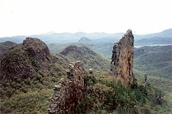
grasslands the park incorporates the most spectactular part of the Warrumbungle mountains
, a region of past volcanic
activity with unusual lava
formations. Some of the most well-known rock formations include Bluff Mountain, Mount Exmouth (tallest mountain in the park), The Breadknife
, Split Rock, Fans Horizon and Crater Bluff.
 There are many scenic bushwalks and both rock climbing and abseiling are popular. The park preserves habitat for a koala
population numbering in the hundreds. It is also home to the Australian Astronomical Observatory, which has one of the largest optical telescopes in the southern hemisphere.
s. All camping in the park is only permitted after obtaining a permit
. There is a visitors centre for bookings and keys to a number of hut
s. The park also caters for large school
groups. There are free electric barbecues available however firewood
is not supplied or to be collected within park grounds.
. The construction of a network of walking tracks done by hand was headed by the parks first ranger, Carl Dow. The park was added to the list of the National Heritage in December, 2006.
New South Wales
New South Wales is a state of :Australia, located in the east of the country. It is bordered by Queensland, Victoria and South Australia to the north, south and west respectively. To the east, the state is bordered by the Tasman Sea, which forms part of the Pacific Ocean. New South Wales...
, Australia
Australia
Australia , officially the Commonwealth of Australia, is a country in the Southern Hemisphere comprising the mainland of the Australian continent, the island of Tasmania, and numerous smaller islands in the Indian and Pacific Oceans. It is the world's sixth-largest country by total area...
, 550 km northwest of Sydney. Outside of the Sydney metropolitan area parks, it is the most-visited national park in New South Wales.
The official name is Warrumbungle National Park, based on the geographical name Warrumbungle Mountain Range
Warrumbungles
The Warrumbungles is the name of a mountain range and National Park located in northern New South Wales, Australia. The nearest town to the Warrumbungles is Coonabarabran...
. This range is sometimes shortened to the Warrumbungles, and thus the park name is often heard in the plural. The comic strip Warrumbunglers may also have played some part in this usage.
The park lies within the Pilliga
Pilliga forest
The State Forests of The Pilliga, commonly known as the Pilliga Scrub , constitute some 3000 km2 of semi-arid woodland in temperate north-central New South Wales, Australia...
Important Bird Area
Important Bird Area
An Important Bird Area is an area recognized as being globally important habitat for the conservation of bird populations. Currently there are about 10,000 IBAs worldwide. The program was developed and sites are identified by BirdLife International...
, so identified by BirdLife International
BirdLife International
BirdLife International is a global Partnership of conservation organisations that strives to conserve birds, their habitats and global biodiversity, working with people towards sustainability in the use of natural resources...
because of its importance for a range of woodland bird species, many of which are threatened.
Warrumbungle National Park was added to the Australian National Heritage List
Australian National Heritage List
The Australian National Heritage List is a list of places deemed to be of outstanding heritage significance to Australia. The list includes natural, historic and indigenous places...
in December 2006.
Access
The nearest towns to the park are BaradineBaradine, New South Wales
Baradine is a small town in northern New South Wales, Australia. At the 2006 census, Baradine had a population of 593.Baradine is located on the Coonabarabran-Pilliga road, about midway between Coonabarabran and Pilliga...
, Coonabarabran
Coonabarabran, New South Wales
Coonabarabran is a town in Warrumbungle Shire in northern New South Wales, Australia. At the 2006 census, the town had a population of 2,609.-History and description:...
, Coonamble
Coonamble, New South Wales
Coonamble is a town on the central-western plains of New South Wales, Australia. It lies on the Castlereagh Highway north-west of Gilgandra. At the 2006 census, Coonamble had a population of 2,549...
, Gilgandra
Gilgandra, New South Wales
Gilgandra, is a town and Local Government Area in the Central West region of New South Wales, Australia. It is located on the junction of the Newell Highway, Oxley Highway and Castlereagh Highway. It can be reached in about six hours by car from Sydney. Like Coonabarabran, Gilgandra can be...
, Gulargambone
Gulargambone, New South Wales
Gulargambone is a village in the central west plains of New South Wales, Australia, on the banks of the Castlereagh River, in Coonamble Shire. It is 526 kilometres north west of Sydney. At the 2006 census, Gulargambone had a population of 395....
, and Tooraweenah
Tooraweenah, New South Wales
Tooraweenah is a small village just off the Newell Highway about north east of Gilgandra in the central west of New South Wales, Australia. At the 2006 census, Tooraweenah had a population of 239....
. Access via Coonabarabran to the east is by 27 km of sealed road called the John Renshaw Parkway which was built in 1966. Via Coonamble to the west access is by a 57 km long road with some gravel.
Features

Southeast Australia temperate savanna
The Southeast Australia temperate savanna ecoregion is a large area of grassland dotted with eucalyptus trees running north-south across central New South Wales, Australia.-Location and description:...
grasslands the park incorporates the most spectactular part of the Warrumbungle mountains
Warrumbungles
The Warrumbungles is the name of a mountain range and National Park located in northern New South Wales, Australia. The nearest town to the Warrumbungles is Coonabarabran...
, a region of past volcanic
Volcano
2. Bedrock3. Conduit 4. Base5. Sill6. Dike7. Layers of ash emitted by the volcano8. Flank| 9. Layers of lava emitted by the volcano10. Throat11. Parasitic cone12. Lava flow13. Vent14. Crater15...
activity with unusual lava
Lava
Lava refers both to molten rock expelled by a volcano during an eruption and the resulting rock after solidification and cooling. This molten rock is formed in the interior of some planets, including Earth, and some of their satellites. When first erupted from a volcanic vent, lava is a liquid at...
formations. Some of the most well-known rock formations include Bluff Mountain, Mount Exmouth (tallest mountain in the park), The Breadknife
The Breadknife
The Breadknife is a dyke located in New South Wales, Australia. The dyke is nearly 850 metres high, but often is only 500 m wide, which is particularly rare. The Breadknife was part of a large shield volcano, that first erupted about 18 million years ago and stopped about 15 million...
, Split Rock, Fans Horizon and Crater Bluff.

Koala
The koala is an arboreal herbivorous marsupial native to Australia, and the only extant representative of the family Phascolarctidae....
population numbering in the hundreds. It is also home to the Australian Astronomical Observatory, which has one of the largest optical telescopes in the southern hemisphere.
Facilities
There are four main campsiteCampsite
A campsite or camping pitch is a place used for overnight stay in the outdoors. In British English a campsite is an area, usually divided into a number of pitches, where people can camp overnight using tents or camper vans or caravans; this British English use of the word is synonymous with the...
s. All camping in the park is only permitted after obtaining a permit
Permit
Permit may refer to:*Permit *Various legal licenses:*License*Work permit*Learner's permit*Permit to travel*Construction permit*Home Return Permit*One-way Permit*Permit is the common name for the Trachinotus falcatus, a type of Pompano....
. There is a visitors centre for bookings and keys to a number of hut
Hut
Hut may refer to:*Hut , a small and crude shelter*Hans Hut , Anabaptist leader*Hut Records, an English audio records company*Sunglass Hut International, largest American retailer of sunglasses...
s. The park also caters for large school
School
A school is an institution designed for the teaching of students under the direction of teachers. Most countries have systems of formal education, which is commonly compulsory. In these systems, students progress through a series of schools...
groups. There are free electric barbecues available however firewood
Firewood
Firewood is any wood-like material that is gathered and used for fuel. Generally, firewood is not highly processed and is in some sort of recognizable log or branch form....
is not supplied or to be collected within park grounds.
History
The area was first proclaimed as a reserve in 1953. In 1967 management of the park was signed over to the National Parks and Wildlife ServiceNational Parks and Wildlife Service (New South Wales)
The National Parks and Wildlife Service is part of the Office of Environment and Heritage - the main government conservation agency in New South Wales, Australia....
. The construction of a network of walking tracks done by hand was headed by the parks first ranger, Carl Dow. The park was added to the list of the National Heritage in December, 2006.
See also
- Protected areas of New South Wales

