
Wenatchee Mountains
Encyclopedia
Cascade Range
The Cascade Range is a major mountain range of western North America, extending from southern British Columbia through Washington and Oregon to Northern California. It includes both non-volcanic mountains, such as the North Cascades, and the notable volcanoes known as the High Cascades...
, extending east 50 miles (80.5 km) from the Cascade crest, the Wenatchee Mountains separate the drainage basin
Drainage basin
A drainage basin is an extent or an area of land where surface water from rain and melting snow or ice converges to a single point, usually the exit of the basin, where the waters join another waterbody, such as a river, lake, reservoir, estuary, wetland, sea, or ocean...
s of the Yakima River
Yakima River
The Yakima River is a tributary of the Columbia River in south central and eastern Washington State, named for the indigenous Yakama people. The length of the river from headwaters to mouth is , with an average drop of .-Course:...
from the Wenatchee River
Wenatchee River
The Wenatchee River is a river in the U.S. state of Washington, originating at Lake Wenatchee and flowing southeast for , emptying into the Columbia River immediately north of Wenatchee, Washington...
. The crest of the range forms part of the boundary between Chelan and Kittitas Counties.
Extent
Fred BeckeyFred Beckey
Fred Beckey is an American mountaineer and author, who has made hundreds of first ascents, more than any other North American climber.-Early years:...
describes the Wenatchee Mountains as the area between the Wenatchee and Yakima rivers and Stevens Pass
Stevens Pass
Stevens Pass is a mountain pass through the Cascade Mountains located at the border of King County and Chelan County in Washington, United States....
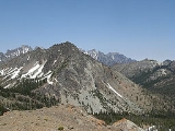
. Among the range's significant features he describes are Mount Stuart
Mount Stuart
Mount Stuart is a mountain in the Cascade Range, in the U.S. state of Washington. It is the second highest non-volcanic peak in the state, after Bonanza Peak and tenth-highest overall...
, the second highest non-volcanic peak in Washington and one of the largest single granitic mountains in the United States, the Cashmere Crags, the Lost World Plateau, Edward Plateau, and Dragontail Plateau, the Enchantment Lakes Basin
The Enchantments
The Enchantments is an area comprising an upper and a lower basin, the lakes and tarns contained within them, and the peaks of the Stuart Range bounding the basins. The area is located entirely within the Alpine Lakes Wilderness about southwest of Leavenworth, Washington in the United States...
("one of the most marvelous examples of an ice-sculpted wilderness in the Cascade Range), Icicle Creek
Icicle Creek
Icicle Creek is a stream in the U.S. state of Washington. It originates at Josephine Lake near the crest of the Cascade Range and flows generally west to join the Wenatchee River near Leavenworth. Icicle Creek's drainage basin is mountainous and mostly undeveloped land within the Wenatchee National...
and its narrow, U-shaped valley over 6000 feet (1,828.8 m) deep, one of the deepest in the Cascades, and the Wenatchee River's unusual winding Tumwater Canyon gorge.
According to Peakbagger.com the Wenatchee Mountains are defined as bounded by U.S. Route 2
U.S. Route 2
U.S. Route 2 is an east–west U.S. Highway spanning across the northern continental United States. US 2 consists of two segments connected by various roadways in southern Canada...
from Stevens Pass
Stevens Pass
Stevens Pass is a mountain pass through the Cascade Mountains located at the border of King County and Chelan County in Washington, United States....
to Wenatchee
Wenatchee, Washington
Wenatchee is located in North Central Washington and is the largest city and county seat of Chelan County, Washington, United States. The population within the city limits in 2010 was 31,925...
on the Columbia River
Columbia River
The Columbia River is the largest river in the Pacific Northwest region of North America. The river rises in the Rocky Mountains of British Columbia, Canada, flows northwest and then south into the U.S. state of Washington, then turns west to form most of the border between Washington and the state...
, then down the Columbia River to Interstate 90
Interstate 90
Interstate 90 is the longest Interstate Highway in the United States at . It is the northernmost coast-to-coast interstate, and parallels US 20 for the most part. Its western terminus is in Seattle, at Edgar Martinez Drive S. near Safeco Field and CenturyLink Field, and its eastern terminus is in...
, then west along the highway to the vicinity of Cle Elum
Cle Elum, Washington
Cle Elum is a city in Kittitas County, Washington, United States. The population was 1,872 at the 2010 census. Only an hour and a half's drive from Seattle, Cle Elum is a popular area for camping and outdoor activities.-Early years and industries:...
and Roslyn
Roslyn, Washington
Roslyn is a city in Kittitas County, Washington, United States. The population was 893 at the 2010 census.-Geography:Roslyn is located at...
, then north along Cle Elum Lake
Cle Elum Lake
Cle Elum Lake is a lake and reservoir along the course of the Cle Elum River, in Washington state USA. Cle Elum Lake is the eastern lake of the three large lakes north of Interstate 90 and the Yakima River in the Cascade Range, the other two being Keechelus Lake and Kachess Lake.Cle Elum Lake is...
and the Cle Elum River
Cle Elum River
The Cle Elum River is a tributary of the Yakima River, approximately 28 miles long in the U.S. state of Washington.The river originates in the Cascade Range near Mount Daniel and flows generally south, through Hyas Lake. The river is joined by many tributary streams including Waptus River and...
and north to Stevens Pass. Subranges of the Wenatchee Mountains and their highest peaks as defined by Peakbagger.com are the Chiwaukum Mountains
Chiwaukum Mountains
The Chiwaukum Mountains are a north-south mountain range in central Washington, USA. They stretch from Snowgrass Mountain at , to .The mountains are made of schist, part of the Nason terrane. The original rock in the Nason terrane was laid down 210 Myr ago...
(Big Chiwaukum Mountain, 8501 feet (2,591.1 m)), North Wenatchee Mountains (Cashmere Mountain, 8501 feet (2,591.1 m)), Stuart Range
Stuart Range
The Stuart Range is a mountain range in central Washington, USA. The range lies within the eastern extent of the Cascade Range immediately southwest of Leavenworth and runs east-west. The western peaks make up a single sharp ridge. The eastern half of the range splits into two parallel ridges,...
(Mount Stuart, 9415 feet (2,869.7 m)), the Teanaway Area (Ingalls Peak, 7662 feet (2,335.4 m)), and the Mission-Naneum Ridges (Mission Peak, 6876 feet (2,095.8 m)). Peakbagger.com also defines and names the mountain regions bordering the Wenatchee Mountains. These are the Alpine Lakes Area to the west, South Cascade Crest to the south, Glacier Peak-North Stevens Pass area to the northwest, and the Entiat Mountains
Entiat Mountains
The Entiat Mountains, or Entiat Range is a mountain range in the U.S. state of Washington. Located west of the Columbia River, north of the Wenatchee River, and south of the Entiat River, the range is part of the North Cascades section of the Cascade Range. The Entiat Range is relatively narrow...
to the northeast.
The USGS GNIS defines the range with a simple list seven points in a line, running from approximately Paddy-Go-Easy Pass and Granite Mountain to approximately Blewett Pass
Blewett Pass
Blewett Pass , is a mountain pass in the Cascades in Washington state crossed by U.S. Highway 97. Named for Edward Blewett, a Seattle mining promoter of the 1880s, it lies on the route of the historical Yellowstone Trail....
and Naneum Creek.
Major Peaks
Partial list of peaks:- Mount StuartMount StuartMount Stuart is a mountain in the Cascade Range, in the U.S. state of Washington. It is the second highest non-volcanic peak in the state, after Bonanza Peak and tenth-highest overall...
- 9415 feet (2,869.7 m) - Dragontail PeakDragontail PeakDragontail Peak, also known as Dragon Tail, is a mountain in the Stuart Range, in Chelan County, Washington. While climbing an adjacent peak, Lex Maxwell, Bob McCall, and Bill Prater remarked that the needles on the crest, southwest of the summit, resembled a "dragon tail". The name was officially...
- 8840 feet (2,694.4 m) - Colchuck Peak - 8705 feet (2,653.3 m)
- Cannon Mountain - 8638 feet (2,632.9 m)
- Sherpa Peak - 8605 feet (2,622.8 m)
- Enchantment Peak - 8520 feet (2,596.9 m)
- Witches Tower - 8520 feet (2,596.9 m)
- Cashmere Mountain - 8501 feet (2,591.1 m)
- Argonaut PeakArgonaut PeakArgonaut Peak is a tall mountain in the Cascade Range in the U.S. state of Washington. Part of the Stuart Range part of the Wenatchee subrange of the Cascades, it is within the Alpine Lakes Wilderness of the Wenatchee National Forest and part of the region known as The Enchantments. At in...
- 8453 feet (2,576.5 m) - Little Annapurna - 8440 feet (2,572.5 m)
- Eightmile Mountain - 7996 feet (2,437.2 m)
- The CradleThe CradleThe Cradle is the second full-length album from Oxford, Mississippi, indie-rock band, Colour Revolt. It is the band's first since drummer Len Clark, bassist Patrick Addison, and guitarist Jimmy Cajoleas left in 2008 and were replaced by drummer Daniel Davison, keyboardist Brooks Tipton, and...
- 7467 feet (2,275.9 m) - Granite MountainGranite Mountain (Washington)According to the , the state of Washington in the United States has 10 peaks named Granite Mountain:...
- 7144 feet (2,177.5 m) - Mac Peak - 6859 feet (2,090.6 m)
- Thunder Mountain Lakes Peak - 6711 feet (2,045.5 m)
- Trico Mountain - 6640 feet (2,023.9 m)
- Thunder Mountain - 6556 feet (1,998.3 m)
- Slippery Slab Tower - 6356 feet (1,937.3 m)
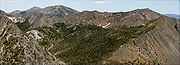
Natural history
The Wenatchee Mountains are in the rain shadowRain shadow
A rain shadow is a dry area on the lee side of a mountainous area. The mountains block the passage of rain-producing weather systems, casting a "shadow" of dryness behind them. As shown by the diagram to the right, the warm moist air is "pulled" by the prevailing winds over a mountain...
of the main Cascade Range and hence have fewer trees. This comparative lack of trees offers good wildflower displays and wide views.
The Wenatchee Mountains are home to the Wenatchee Mountains checkermallow, the rarest plant in Washington, now on the endangered species
Endangered species
An endangered species is a population of organisms which is at risk of becoming extinct because it is either few in numbers, or threatened by changing environmental or predation parameters...
list. This rare flower occurs only along Peshastin Creek, south of Leavenworth, Washington
Leavenworth, Washington
Leavenworth is a city in Chelan County, Washington, United States. It is part of the Wenatchee–East Wenatchee Metropolitan Statistical Area. The population was 1,965 at the 2010 census. The entire town center is modelled on a Bavarian village.-History:...
.