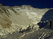
Western Cwm
Encyclopedia

Welsh language
Welsh is a member of the Brythonic branch of the Celtic languages spoken natively in Wales, by some along the Welsh border in England, and in Y Wladfa...
for a bowl shaped valley/Cirque) is a broad, flat, gently undulating glacial valley basin terminating at the foot of the Lhotse
Lhotse
Lhotse is the fourth highest mountain on Earth and is connected to Everest via the South Col. In addition to the main summit at 8,516 metres above sea level, Lhotse Middle is and Lhotse Shar is...
Face of Mount Everest
Mount Everest
Mount Everest is the world's highest mountain, with a peak at above sea level. It is located in the Mahalangur section of the Himalayas. The international boundary runs across the precise summit point...
. It was named by George Leigh Mallory when he first saw it in 1921. It is traversed by climbers using the southeast route to the summit of Everest. The central section is cut by massive lateral crevasses which bar entrance into the upper Western Cwm. In this section, climbers must cross to the far right, over to the base of Nuptse
Nuptse
Nuptse is a mountain in the Khumbu region of the Mahalangur Himal, in the Nepalese Himalayas. It lies two kilometres WSW of Mount Everest. Nuptse is Tibetan for "west peak", as it is the western segment of the Lhotse-Nuptse massif....
to a narrow passageway known as the Nuptse corner. From there, climbers have a stupendous view of the upper 8,000 feet of Everest—the first glimpse of Everest's upper slopes since arriving at Base Camp
Everest Base Camp
There are two base camps on opposite sides of Mount Everest. South Base Camp is in Nepal at an altitude of , and North Base Camp is in Tibet at ). These camps are rudimentary campsites on Mount Everest that are used by mountain climbers during their ascent and descent...
. The last 5,000 feet on Everest, including its distinct black pyramid summit, are not visible from Base Camp. The snow-covered, bowl-shaped slopes surrounding the Western Cwm reflect and amplify the solar radiation, warming the valley basin despite its high elevation of 6000 to 6800 meters (19,600–22,300 feet). Some of the most difficult days on Everest are in the Western Cwm, when on a sunny windless day it is desperately hot, up to 35 degrees Celsius (95 degrees Fahrenheit).

