
Westland District
Encyclopedia
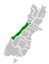
Westland District is a territorial authority
on the west coast
of New Zealand
's South Island
. Its population is
, headed by an elected Mayor
. The Mayor is elected at large. The current Mayor is Maureen Pugh. Councillors are elected to represent multi-member wards. Three councillors are elected for the Northern Ward, three for the Southern Ward, and four for the town of Hokitika.
The District is one of three included within the West Coast Region
.
and the Tasman Sea
. The low-lying areas near the coast are a mixture of pastoral farmland and temperate rainforest
. The eastern part of the District is steep and mountainous. Many small rivers flow down from the mountains.
The southern part of the District notably contains the Franz Josef
and Fox
glacier
s.
Westland is one of the most sparsely populated parts of the country, with an area of 11,880.19 square kilometres and a population of 8,403 people (2006 census). Approximately 45% of the population lives in Hokitika (popn.3500). The remaining 55% lives in small villages such as Ross
, Franz Josef
and Haast
, or in rural areas.
In the north, the Taramakau River
, the largest river in the district, forms the boundary with the Grey District
. The crest of the Southern Alps marks the eastern boundary. A small southern boundary lies between Westland proper and Fiordland
, which lies within the Southland District
. This boundary cannot be crossed by road.
was a major commodity, causing prospectors to flock into the area. After the gold ran out, those who remained turned to pastoral farming. (Unlike the more northern parts of the West Coast, Westland has not developed coal mining.) In recent years, tourism has become more important, with drawcards such as the glaciers, as well as events such as the Hokitika Wild Foods Festival.
, administered from Christchurch
in the East coast. The booming population as a result of the gold rush
, together with the difficulty of travel and communication across the Southern Alps, led first to the creation of a special "Westland County", then the formal separation of Westland from Canterbury to form the short-lived Westland Province
(1873 - 1876). Westland Province also included what is now the southern portion of Grey District with the provincial boundary at the Grey and Arnold
rivers. Greymouth
proper was in Westland Province, Cobden
, on the north bank of the Grey River, was in Nelson Province
.
After the abolition of the provinces in 1876, a new Westland County was created with roughly the same borders as the old Province. About this time, the population relative to the rest of the country began to decline, as the easily accessible gold soon ran out and the conditions were not ideal for farming. Local government changes saw the hinterland of Greymouth on both sides of the Grey River transformed into Greymouth Borough and Grey County and subsequently into Grey District, which includes portions of both historical provinces.
However Westland, as a unit of government, emerged largely intact from the local government reforms of the 1980s and 1990s, merely changing from a County to a District and incorporating the Borough of Hokitika.
Recently the population has begun to grow more quickly due to "lifestyle" residents moving into the District.
Territorial authorities of New Zealand
Territorial authorities are the second tier of local government in New Zealand, below regional councils. There are 67 territorial authorities: 13 city councils, 53 district councils, and the Chatham Islands Council...
on the west coast
West Coast, New Zealand
The West Coast is one of the administrative regions of New Zealand, located on the west coast of the South Island, and is one of the more remote and most sparsely populated areas of the country. It is made up of three districts: Buller, Grey and Westland...
of New Zealand
New Zealand
New Zealand is an island country in the south-western Pacific Ocean comprising two main landmasses and numerous smaller islands. The country is situated some east of Australia across the Tasman Sea, and roughly south of the Pacific island nations of New Caledonia, Fiji, and Tonga...
's South Island
South Island
The South Island is the larger of the two major islands of New Zealand, the other being the more populous North Island. It is bordered to the north by Cook Strait, to the west by the Tasman Sea, to the south and east by the Pacific Ocean...
. Its population is
Government
The Westland District is governed by an elected CouncilCity council
A city council or town council is the legislative body that governs a city, town, municipality or local government area.-Australia & NZ:Because of the differences in legislation between the States, the exact definition of a City Council varies...
, headed by an elected Mayor
Mayor
In many countries, a Mayor is the highest ranking officer in the municipal government of a town or a large urban city....
. The Mayor is elected at large. The current Mayor is Maureen Pugh. Councillors are elected to represent multi-member wards. Three councillors are elected for the Northern Ward, three for the Southern Ward, and four for the town of Hokitika.
The District is one of three included within the West Coast Region
West Coast, New Zealand
The West Coast is one of the administrative regions of New Zealand, located on the west coast of the South Island, and is one of the more remote and most sparsely populated areas of the country. It is made up of three districts: Buller, Grey and Westland...
.
Geography
The District consists of a long thin strip of land between the crest of the Southern AlpsSouthern Alps
The Southern Alps is a mountain range extending along much of the length of New Zealand's South Island, reaching its greatest elevations near the island's western side...
and the Tasman Sea
Tasman Sea
The Tasman Sea is the large body of water between Australia and New Zealand, approximately across. It extends 2,800 km from north to south. It is a south-western segment of the South Pacific Ocean. The sea was named after the Dutch explorer Abel Janszoon Tasman, the first recorded European...
. The low-lying areas near the coast are a mixture of pastoral farmland and temperate rainforest
Rainforest
Rainforests are forests characterized by high rainfall, with definitions based on a minimum normal annual rainfall of 1750-2000 mm...
. The eastern part of the District is steep and mountainous. Many small rivers flow down from the mountains.
The southern part of the District notably contains the Franz Josef
Franz Josef Glacier
The Franz Josef is a long glacier located in Westland Tai Poutini National Park on the West Coast of New Zealand's South Island...
and Fox
Fox Glacier
The Fox Glacier is a long glacier located in Westland Tai Poutini National Park on the West Coast of New Zealand's South Island...
glacier
Glacier
A glacier is a large persistent body of ice that forms where the accumulation of snow exceeds its ablation over many years, often centuries. At least 0.1 km² in area and 50 m thick, but often much larger, a glacier slowly deforms and flows due to stresses induced by its weight...
s.
Westland is one of the most sparsely populated parts of the country, with an area of 11,880.19 square kilometres and a population of 8,403 people (2006 census). Approximately 45% of the population lives in Hokitika (popn.3500). The remaining 55% lives in small villages such as Ross
Ross, New Zealand
Ross is a small town located on the West Coast of New Zealand's South Island.It lies 27 kilometres south-west of Hokitika and 46 kilometres north-east of Harihari...
, Franz Josef
Franz Josef, New Zealand
Franz Josef is a small town in the West Coast region of the South Island of New Zealand. Whataroa is 32 km to the north-east, and the township of Fox Glacier is 23 km to the south-west. State Highway 6 runs through the town...
and Haast
Haast, New Zealand
Haast is an area in the Westland District territorial authority on the west coast of New Zealand's South Island. The Haast region covers over ....
, or in rural areas.
In the north, the Taramakau River
Taramakau River
The Taramakau River is in the northwest of the South Island of New Zealand. It rises in the Southern Alps, 80 kilometres due east of Hokitika, and immediately below the saddle of the Harper's Pass, and runs westward for 75 kilometres into the Tasman Sea 15 kilometres south of Greymouth.Several...
, the largest river in the district, forms the boundary with the Grey District
Grey District
Grey District Council in the West Coast region of New Zealand is a municipality that covers Greymouth, Runanga, Blackball, Cobden and settlements along the Grey River. It has a land area of 3,516.48 km²...
. The crest of the Southern Alps marks the eastern boundary. A small southern boundary lies between Westland proper and Fiordland
Fiordland
Fiordland is a geographic region of New Zealand that is situated on the south-western corner of the South Island, comprising the western-most third of Southland. Most of Fiordland is dominated by the steep sides of the snow-capped Southern Alps, deep lakes and its ocean-flooded, steep western valleys...
, which lies within the Southland District
Southland District
Southland District is a territorial authority in the South Island of New Zealand. Southland District covers the majority of the land area of Southland Region, although the region also covers Gore District, Invercargill City and adjacent territorial waters...
. This boundary cannot be crossed by road.
Economy
In the early years of settlement in Westland, goldGold
Gold is a chemical element with the symbol Au and an atomic number of 79. Gold is a dense, soft, shiny, malleable and ductile metal. Pure gold has a bright yellow color and luster traditionally considered attractive, which it maintains without oxidizing in air or water. Chemically, gold is a...
was a major commodity, causing prospectors to flock into the area. After the gold ran out, those who remained turned to pastoral farming. (Unlike the more northern parts of the West Coast, Westland has not developed coal mining.) In recent years, tourism has become more important, with drawcards such as the glaciers, as well as events such as the Hokitika Wild Foods Festival.
History
Westland was originally a part of Canterbury ProvinceCanterbury Province
The Canterbury Province was a province of New Zealand from 1853 until the abolition of provincial government in 1876. On the east coast the province was bounded by the Hurunui River in the north and the Waitaki River in the south...
, administered from Christchurch
Christchurch
Christchurch is the largest city in the South Island of New Zealand, and the country's second-largest urban area after Auckland. It lies one third of the way down the South Island's east coast, just north of Banks Peninsula which itself, since 2006, lies within the formal limits of...
in the East coast. The booming population as a result of the gold rush
Gold rush
A gold rush is a period of feverish migration of workers to an area that has had a dramatic discovery of gold. Major gold rushes took place in the 19th century in Australia, Brazil, Canada, South Africa, and the United States, while smaller gold rushes took place elsewhere.In the 19th and early...
, together with the difficulty of travel and communication across the Southern Alps, led first to the creation of a special "Westland County", then the formal separation of Westland from Canterbury to form the short-lived Westland Province
Westland Province
The Westland Province was a province of New Zealand from 1873 until the abolition of provincial government in 1876. The capital was Hokitika.-Area:...
(1873 - 1876). Westland Province also included what is now the southern portion of Grey District with the provincial boundary at the Grey and Arnold
Arnold River, New Zealand
The Arnold River is located in the west of New Zealand's South Island. It is the outflow of Lake Brunner, which it links with the Grey River. The Arnold River flows northwest for 20 kilometres, joining the Grey immediately above the town of Brunner, some 15 kilometres from the Tasman Sea...
rivers. Greymouth
Greymouth
Greymouth is the largest town in the West Coast region in the South Island of New Zealand, and the seat of the Grey District Council. The population of the whole Grey District is , which accounts for % of the West Coast's inhabitants...
proper was in Westland Province, Cobden
Cobden, New Zealand
Cobden is a suburb to the north of Greymouth on the West Coast of New Zealand. The Grey River separates Cobden from the rest of Greymouth. To the north is the Rapahoe Range, also called the Twelve Apostles Range...
, on the north bank of the Grey River, was in Nelson Province
Nelson Province
The Nelson Province was a province of New Zealand from 1853 until the abolition of provincial government in 1876.-History:The Marlborough Province split away from the Nelson Province on 1 November 1859 because the majority of the income of the Provincial Council came from land sales in the...
.
After the abolition of the provinces in 1876, a new Westland County was created with roughly the same borders as the old Province. About this time, the population relative to the rest of the country began to decline, as the easily accessible gold soon ran out and the conditions were not ideal for farming. Local government changes saw the hinterland of Greymouth on both sides of the Grey River transformed into Greymouth Borough and Grey County and subsequently into Grey District, which includes portions of both historical provinces.
However Westland, as a unit of government, emerged largely intact from the local government reforms of the 1980s and 1990s, merely changing from a County to a District and incorporating the Borough of Hokitika.
Recently the population has begun to grow more quickly due to "lifestyle" residents moving into the District.