Wetherby Ings
Encyclopedia

Ings
Ings is an old Yorkshire word for water meadows & marshes, including those which were part of the Humber flood plain.Ings often teem with large numbers of water birds and other wildlife...
on the River Wharfe
River Wharfe
The River Wharfe is a river in Yorkshire, England. For much of its length it is the county boundary between West Yorkshire and North Yorkshire. The name Wharfe is Celtic and means "twisting, winding".The valley of the River Wharfe is known as Wharfedale...
and the largest parkland area in Wetherby
Wetherby
Wetherby is a market town and civil parish within the metropolitan borough of the City of Leeds, in West Yorkshire, England. It stands on the River Wharfe, and has been for centuries a crossing place and staging post on the Great North Road, being mid-way between London and Edinburgh...
, West Yorkshire
West Yorkshire
West Yorkshire is a metropolitan county within the Yorkshire and the Humber region of England with a population of 2.2 million. West Yorkshire came into existence as a metropolitan county in 1974 after the passage of the Local Government Act 1972....
. As well as being used as parkland the area is used as sports ground for both the towns Football and Rugby League teams.
North Bank
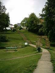
The North Bank, or King George's Field (known locally as Scaur Bank) is purely used as public space, with a football pitch, playground and open grass, it is linked to the South bank by footbridge.The North Bank has several footpaths, including one which runs along the side of the River Wharfe, and the remains of some concrete 1930's steps which were used by locals during the summer months in years past.
Prior to the extension of the Linton Golf Club walkers could follow a path alongside the North Bank all the way to Linton Bridge: but now the walk is curtailed through the golf club (Personally speaking I am unaware of any consultation by the golf club and the towns people as to rights of way which once used to exist along the North Bank).
South Bank
The South Bank is the sports ground for Wetherby Athletic AFC and Wetherby Bulldogs RLFC, this consists of several Football and Rugby pitches as well as all weather pitches a club house and car park. There is also a skate park on the South Bank. Angling takes place along parts of the South bank. The main leisure centre in Wetherby lies along the edge of the Southern Ings.The South Bank now extends all the way to Collingham St Oswald's Church from a gate in the west corner of the sports and recreation grounds; through what used to be primarily a field for sheep. This disused field to the west of the sports grounds is now a haven for wild flowers and shrubs in the spring and it also gives walkers great views back across to the valley to Linton and Westgate, Wetherby.

