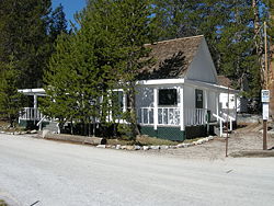
White Wolf (Yosemite)
Encyclopedia

Yosemite National Park
Yosemite National Park is a United States National Park spanning eastern portions of Tuolumne, Mariposa and Madera counties in east central California, United States. The park covers an area of and reaches across the western slopes of the Sierra Nevada mountain chain...
(37°52′14.44"N 119°38′49.52"W) along Tioga Road (HWY 120), is a first-come first-served campground and concession area outside of Yosemite Valley
Yosemite Valley
Yosemite Valley is a glacial valley in Yosemite National Park in the western Sierra Nevada mountains of California, carved out by the Merced River. The valley is about long and up to a mile deep, surrounded by high granite summits such as Half Dome and El Capitan, and densely forested with pines...
. The campground is directly off the road and thus does not require a rough drive to the campground like other Yosemite campgrounds outside of the Valley (Yosemite Creek and Tamarack Flat are examples 2-4 mile unpaved roads leading into the campground off the main road). White Wolf Campground contains 74 campsites and has the look and feel of Bridalveil Creek
Bridalveil Creek
thumb|300px|right| Hanging valley of Bridalveil Creek, showing its pronounced form which is controlled, in large measure, by sparse diagonal joint structures....
Campground. The campground is not directly located near a creek and is quite rocky and sunny. The area also includes a cluster of wood and canvas cabins and a small restaurant and general store.
Settlement in the White Wolf area began in the early 20th century, after the construction of the Tioga Road. The first structures were likely shelters for ranch hands, and by 1930 the area was home to a small resort which included tents, tourist cabins, a small store and restaurant, and a gas station. After a drop in tourism following World War II
World War II
World War II, or the Second World War , was a global conflict lasting from 1939 to 1945, involving most of the world's nations—including all of the great powers—eventually forming two opposing military alliances: the Allies and the Axis...
and the relocation of the highway, the land was purchased by the government, with concession rights held by the Yosemite Park and Curry Co. The public campground was improved in 1960-1961.
Sources differ on the origin of the name. According to one story, cattlemen pursuing horse thieves in 1850 came upon an encampment of Indians led by a tribal chief whose name was White Wolf, and named the place after him. Another story is that it was named by a sheepherder who saw a white wolf in the area.
Destinations Nearby
Heading North-East- Yosemite Creek Campground (20 Min)
- Porcupine Flat Campground Campground (14 Min)
- Olmsted PointOlmsted PointOlmsted Point, located in Yosemite National Park, is a viewing area off of the Tioga Road like Glacier Point that offers a view looking southwest into Yosemite Valley, in particular a view of the northern side of Half Dome and a view of Tenaya Lake to the east.The site is named after...
(23 Min) - Tenaya LakeTenaya LakeTenaya Lake is a lake in Yosemite National Park, located between Yosemite Valley and Tuolumne Meadows.Tenaya Lake was created by the Tenaya branch of the Tuolumne Glacier as it passed through Tenaya Canyon. The lake is supplied by a network of creeks and springs including Murphy Creek to the...
(25 Min) - Tuolumne MeadowsTuolumne MeadowsTuolumne Meadows is a gentle, dome-studded sub-alpine meadowy section of the Tuolumne River, in the eastern section of Yosemite National Park. Its approximate location is . Its approximate elevation is 8619 feet .-Natural History:...
(34 Min)
Heading South-East
- Tamarack Flat Campground (13 Min)
- Crane Flat Campground (19 Min)
- Yosemite ValleyYosemite ValleyYosemite Valley is a glacial valley in Yosemite National Park in the western Sierra Nevada mountains of California, carved out by the Merced River. The valley is about long and up to a mile deep, surrounded by high granite summits such as Half Dome and El Capitan, and densely forested with pines...
(40 Min)

