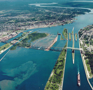
Whitefish Island (Ontario)
Encyclopedia

St. Marys River (Michigan-Ontario)
The St. Marys River , sometimes written as the St. Mary's River, drains Lake Superior, starting at the end of Whitefish Bay and flowing 74.5 miles southeast into Lake Huron, with a fall of ....
, just south of Sault Ste. Marie
Sault Ste. Marie, Ontario
Sault Ste. Marie is a city on the St. Marys River in Algoma District, Ontario, Canada. It is the third largest city in Northern Ontario, after Sudbury and Thunder Bay, with a population of 74,948. The community was founded as a French religious mission: Sault either means "jump" or "rapids" in...
, Ontario
Ontario
Ontario is a province of Canada, located in east-central Canada. It is Canada's most populous province and second largest in total area. It is home to the nation's most populous city, Toronto, and the nation's capital, Ottawa....
. It was an ancestral fishing station to the Anishenabek people of the Great Lakes for over 2,000 years. It was reserved for the use of Chief `Joe Sayer' Nebenaigoching and his band in a treaty in 1850 with the British Crown. After it was taken in a series of expropriations from 1902-1913 for railway purposes, it became a park in the Parks Canada national inventory. A land claim was filed in 1982 by the Batchewana Indian Band for the 22 acres (89,030.9 m²) island. After years of unsuccessful negotiations, hereditary Chief Edward James Sayers Nebenaigoching occupied the island from 1989 until the claim was settled in 1992. Three and a half million dollars in damages were paid and the island was returned to Indian reserve status in 1997.
The island was designated a National Historic Site of Canada in 1981.

