
.gif)
Wild Rice River (North Dakota)
Encyclopedia
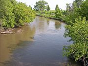
The Wild Rice River is a tributary
of the Red River of the North
, approximately 251 miles (403.9 km) long, in southeastern North Dakota
in the United States
. Via the Red River, Lake Winnipeg
, and the Nelson River
, it is part of the watershed
of Hudson Bay
. The Wild Rice River drains an area of 2233 square miles (5,783.4 km²) in the Red River Valley
region. Its tributaries also drain a small part of northeastern South Dakota
. Despite its length, it is a fairly small stream, flowing at an average rate of approximately 100 cubic feet per second (3 m³/s).
 The Wild Rice River rises as an intermittent stream in Brampton Township
in southeastern Sargent County
, approximately 6 miles (10 km) south of Cogswell
. It initially flows generally eastwardly in a winding course through Sargent and Richland
counties, through the Tewaukon National Wildlife Refuge
and past the towns of Cayuga
, Mantador
and Great Bend
. Past Great Bend, the river turns northward; from west of the city of Wahpeton
it generally parallels the Red River in a winding channel at a distance of approximately 3 to 7 mi (4.8 to 11.3 ). It flows into the Red River in southeastern Cass County
, approximately 3 miles (5 km) southeast of Frontier
and 7 miles (11 km) south of Fargo
.
operates a stream gauge
on the river 3.2 miles (5.1 km) northwest of Abercrombie
. Between 1932 and 2005, the annual mean flow of the river at the gauge was 104 cubic feet per second (3 m³/s). The river's highest flow during the period was 9,540 ft³/s (270 m³/s) on April 11, 1969. Readings of zero have also been recorded.
At an upstream gauge near Rutland
in Sargent County, the annual mean flow between 1960 and 1982 was 8.36 ft³/s (0 m³/s). A reading of 2,700 ft³/s (76 m³/s) was recorded on April 3, 1997.
of the Red River of the North
, approximately 251 miles (403.9 km) long, in southeastern North Dakota
in the United States
. Via the Red River, Lake Winnipeg
, and the Nelson River
, it is part of the watershed
of Hudson Bay
. The Wild Rice River drains an area of 2233 square miles (5,783.4 km²) in the Red River Valley
region. Its tributaries also drain a small part of northeastern South Dakota
. Despite its length, it is a fairly small stream, flowing at an average rate of approximately 100 cubic feet per second (3 m³/s).
The Wild Rice River rises as an intermittent stream in Brampton Township
in southeastern Sargent County
, approximately 6 miles (10 km) south of Cogswell
. It initially flows generally eastwardly in a winding course through Sargent and Richland
counties, through the Tewaukon National Wildlife Refuge
and past the towns of Cayuga
, Mantador
and Great Bend
. Past Great Bend, the river turns northward; from west of the city of Wahpeton
it generally parallels the Red River in a winding channel at a distance of approximately 3 to 7 mi (4.8 to 11.3 ). It flows into the Red River in southeastern Cass County
, approximately 3 miles (5 km) southeast of Frontier
and 7 miles (11 km) south of Fargo
.
operates a stream gauge
on the river 3.2 miles (5.1 km) northwest of Abercrombie
. Between 1932 and 2005, the annual mean flow of the river at the gauge was 104 cubic feet per second (3 m³/s). The river's highest flow during the period was 9,540 ft³/s (270 m³/s) on April 11, 1969. Readings of zero have also been recorded.
At an upstream gauge near Rutland
in Sargent County, the annual mean flow between 1960 and 1982 was 8.36 ft³/s (0 m³/s). A reading of 2,700 ft³/s (76 m³/s) was recorded on April 3, 1997.
|accessdate=2007-06-15}}
Tributary
A tributary or affluent is a stream or river that flows into a main stem river or a lake. A tributary does not flow directly into a sea or ocean...
of the Red River of the North
Red River of the North
The Red River is a North American river. Originating at the confluence of the Bois de Sioux and Otter Tail rivers in the United States, it flows northward through the Red River Valley and forms the border between the U.S. states of Minnesota and North Dakota before continuing into Manitoba, Canada...
, approximately 251 miles (403.9 km) long, in southeastern North Dakota
North Dakota
North Dakota is a state located in the Midwestern region of the United States of America, along the Canadian border. The state is bordered by Canada to the north, Minnesota to the east, South Dakota to the south and Montana to the west. North Dakota is the 19th-largest state by area in the U.S....
in the United States
United States
The United States of America is a federal constitutional republic comprising fifty states and a federal district...
. Via the Red River, Lake Winnipeg
Lake Winnipeg
Lake Winnipeg is a large, lake in central North America, in the province of Manitoba, Canada, with its southern tip about north of the city of Winnipeg...
, and the Nelson River
Nelson River
The Nelson River is a river of north-central North America, in the Canadian province of Manitoba. Its full length is , it has mean discharge of , and has a drainage basin of , of which is in the United States...
, it is part of the watershed
Drainage basin
A drainage basin is an extent or an area of land where surface water from rain and melting snow or ice converges to a single point, usually the exit of the basin, where the waters join another waterbody, such as a river, lake, reservoir, estuary, wetland, sea, or ocean...
of Hudson Bay
Hudson Bay
Hudson Bay , sometimes called Hudson's Bay, is a large body of saltwater in northeastern Canada. It drains a very large area, about , that includes parts of Ontario, Quebec, Saskatchewan, Alberta, most of Manitoba, southeastern Nunavut, as well as parts of North Dakota, South Dakota, Minnesota,...
. The Wild Rice River drains an area of 2233 square miles (5,783.4 km²) in the Red River Valley
Red River Valley
The Red River Valley is a region in central North America that is drained by the Red River of the North. It is significant in the geography of North Dakota, Minnesota, and Manitoba for its relatively fertile lands and the population centers of Fargo, Moorhead, Grand Forks, and Winnipeg...
region. Its tributaries also drain a small part of northeastern South Dakota
South Dakota
South Dakota is a state located in the Midwestern region of the United States. It is named after the Lakota and Dakota Sioux American Indian tribes. Once a part of Dakota Territory, South Dakota became a state on November 2, 1889. The state has an area of and an estimated population of just over...
. Despite its length, it is a fairly small stream, flowing at an average rate of approximately 100 cubic feet per second (3 m³/s).
Course
Brampton Township, Sargent County, North Dakota
Brampton Township is a civil township in Sargent County, North Dakota, United States.Brampton Cemetery is outside city limits.61 of the 66 residents are white, four are Native, and one is "two or more races".-External links:*...
in southeastern Sargent County
Sargent County, North Dakota
-National protected areas:*Storm Lake National Wildlife Refuge*Tewaukon National Wildlife Refuge*Wild Rice Lake National Wildlife Refuge-Demographics:...
, approximately 6 miles (10 km) south of Cogswell
Cogswell, North Dakota
As of the census of 2000, there were 165 people, 68 households, and 49 families residing in the city. The population density was 493.4 people per square mile . There were 81 housing units at an average density of 242.2 per square mile . The racial makeup of the city was 99.39% White, and 0.61% from...
. It initially flows generally eastwardly in a winding course through Sargent and Richland
Richland County, North Dakota
-History:Richland County wa formed in 1873. It was named for Morgan T. Rich, an early settler in the area.-Demographics:As of the census of 2000, there were 17,998 people, 6,885 households, and 4,427 families residing in the county. The population density was 12 people per square mile . There...
counties, through the Tewaukon National Wildlife Refuge
Tewaukon National Wildlife Refuge
Tewaukon National Wildlife Refuge is located in southeastern North Dakota along the western edge of the northern tallgrass prairie, about south of Cayuga, in Sargent County. The Wild Rice River flows through the Refuge and then into Lake Tewaukon...
and past the towns of Cayuga
Cayuga, North Dakota
As of the census of 2000, there were 61 people, 26 households, and 13 families residing in the city. The population density was 61.8 people per square mile . There were 32 housing units at an average density of 32.4 per square mile...
, Mantador
Mantador, North Dakota
As of the census of 2000, there were 71 people, 31 households, and 15 families residing in the city. The population density was 501.5 people per square mile . There were 37 housing units at an average density of 261.4 per square mile...
and Great Bend
Great Bend, North Dakota
As of the 2000 Census, there were 118 people, 40 households, and 33 families residing in the city. The population density was 207.6 people per square mile . There were 42 housing units at an average density of 73.9 per square mile...
. Past Great Bend, the river turns northward; from west of the city of Wahpeton
Wahpeton, North Dakota
The first European explorer in the area was Jonathan Carver in 1767. He explored and mapped the Northwest at the request of Major Robert Rogers, commander of Fort Michilimackinac, the British fort at Mackinaw City, Michigan, which protected the passage between Lake Michigan and Lake Huron...
it generally parallels the Red River in a winding channel at a distance of approximately 3 to 7 mi (4.8 to 11.3 ). It flows into the Red River in southeastern Cass County
Cass County, North Dakota
-Demographics:As of the census of 2000, there were 123,138 people, 51,315 households, and 29,814 families residing in the county. The population density was 70 people per square mile . There were 53,790 housing units at an average density of 30 per square mile...
, approximately 3 miles (5 km) southeast of Frontier
Frontier, North Dakota
As of the census of 2000, there were 273 people, 78 households, and 73 families residing in the city. The population density was 1,522.5 people per square mile . There were 78 housing units at an average density of 435.0 per square mile . The racial makeup of the city was 99.27% White and 0.73%...
and 7 miles (11 km) south of Fargo
Fargo, North Dakota
Fargo is the largest city in the U.S. state of North Dakota and the county seat of Cass County. In 2010, its population was 105,549, and it had an estimated metropolitan population of 208,777...
.
Flow rate
The United States Geological SurveyUnited States Geological Survey
The United States Geological Survey is a scientific agency of the United States government. The scientists of the USGS study the landscape of the United States, its natural resources, and the natural hazards that threaten it. The organization has four major science disciplines, concerning biology,...
operates a stream gauge
Stream gauge
A stream gauge, stream gage or gauging station is a location used by hydrologists or environmental scientists to monitor and test terrestrial bodies of water. Hydrometric measurements of water surface elevation and/or volumetric discharge are generally taken and observations of biota may also be...
on the river 3.2 miles (5.1 km) northwest of Abercrombie
Abercrombie, North Dakota
As of the census of 2000, there were 296 people, 118 households, and 73 families residing in the city. The population density was 482.6 people per square mile . There were 138 housing units at an average density of 225.0 per square mile...
. Between 1932 and 2005, the annual mean flow of the river at the gauge was 104 cubic feet per second (3 m³/s). The river's highest flow during the period was 9,540 ft³/s (270 m³/s) on April 11, 1969. Readings of zero have also been recorded.
At an upstream gauge near Rutland
Rutland, North Dakota
As of the census of 2000, there were 220 people, 91 households, and 53 families residing in the city. The population density was 581.3 people per square mile . There were 102 housing units at an average density of 269.5 per square mile...
in Sargent County, the annual mean flow between 1960 and 1982 was 8.36 ft³/s (0 m³/s). A reading of 2,700 ft³/s (76 m³/s) was recorded on April 3, 1997.
Sources
The Wild Rice River is a tributaryTributary
A tributary or affluent is a stream or river that flows into a main stem river or a lake. A tributary does not flow directly into a sea or ocean...
of the Red River of the North
Red River of the North
The Red River is a North American river. Originating at the confluence of the Bois de Sioux and Otter Tail rivers in the United States, it flows northward through the Red River Valley and forms the border between the U.S. states of Minnesota and North Dakota before continuing into Manitoba, Canada...
, approximately 251 miles (403.9 km) long, in southeastern North Dakota
North Dakota
North Dakota is a state located in the Midwestern region of the United States of America, along the Canadian border. The state is bordered by Canada to the north, Minnesota to the east, South Dakota to the south and Montana to the west. North Dakota is the 19th-largest state by area in the U.S....
in the United States
United States
The United States of America is a federal constitutional republic comprising fifty states and a federal district...
. Via the Red River, Lake Winnipeg
Lake Winnipeg
Lake Winnipeg is a large, lake in central North America, in the province of Manitoba, Canada, with its southern tip about north of the city of Winnipeg...
, and the Nelson River
Nelson River
The Nelson River is a river of north-central North America, in the Canadian province of Manitoba. Its full length is , it has mean discharge of , and has a drainage basin of , of which is in the United States...
, it is part of the watershed
Drainage basin
A drainage basin is an extent or an area of land where surface water from rain and melting snow or ice converges to a single point, usually the exit of the basin, where the waters join another waterbody, such as a river, lake, reservoir, estuary, wetland, sea, or ocean...
of Hudson Bay
Hudson Bay
Hudson Bay , sometimes called Hudson's Bay, is a large body of saltwater in northeastern Canada. It drains a very large area, about , that includes parts of Ontario, Quebec, Saskatchewan, Alberta, most of Manitoba, southeastern Nunavut, as well as parts of North Dakota, South Dakota, Minnesota,...
. The Wild Rice River drains an area of 2233 square miles (5,783.4 km²) in the Red River Valley
Red River Valley
The Red River Valley is a region in central North America that is drained by the Red River of the North. It is significant in the geography of North Dakota, Minnesota, and Manitoba for its relatively fertile lands and the population centers of Fargo, Moorhead, Grand Forks, and Winnipeg...
region. Its tributaries also drain a small part of northeastern South Dakota
South Dakota
South Dakota is a state located in the Midwestern region of the United States. It is named after the Lakota and Dakota Sioux American Indian tribes. Once a part of Dakota Territory, South Dakota became a state on November 2, 1889. The state has an area of and an estimated population of just over...
. Despite its length, it is a fairly small stream, flowing at an average rate of approximately 100 cubic feet per second (3 m³/s).
Course
Brampton Township, Sargent County, North Dakota
Brampton Township is a civil township in Sargent County, North Dakota, United States.Brampton Cemetery is outside city limits.61 of the 66 residents are white, four are Native, and one is "two or more races".-External links:*...
in southeastern Sargent County
Sargent County, North Dakota
-National protected areas:*Storm Lake National Wildlife Refuge*Tewaukon National Wildlife Refuge*Wild Rice Lake National Wildlife Refuge-Demographics:...
, approximately 6 miles (10 km) south of Cogswell
Cogswell, North Dakota
As of the census of 2000, there were 165 people, 68 households, and 49 families residing in the city. The population density was 493.4 people per square mile . There were 81 housing units at an average density of 242.2 per square mile . The racial makeup of the city was 99.39% White, and 0.61% from...
. It initially flows generally eastwardly in a winding course through Sargent and Richland
Richland County, North Dakota
-History:Richland County wa formed in 1873. It was named for Morgan T. Rich, an early settler in the area.-Demographics:As of the census of 2000, there were 17,998 people, 6,885 households, and 4,427 families residing in the county. The population density was 12 people per square mile . There...
counties, through the Tewaukon National Wildlife Refuge
Tewaukon National Wildlife Refuge
Tewaukon National Wildlife Refuge is located in southeastern North Dakota along the western edge of the northern tallgrass prairie, about south of Cayuga, in Sargent County. The Wild Rice River flows through the Refuge and then into Lake Tewaukon...
and past the towns of Cayuga
Cayuga, North Dakota
As of the census of 2000, there were 61 people, 26 households, and 13 families residing in the city. The population density was 61.8 people per square mile . There were 32 housing units at an average density of 32.4 per square mile...
, Mantador
Mantador, North Dakota
As of the census of 2000, there were 71 people, 31 households, and 15 families residing in the city. The population density was 501.5 people per square mile . There were 37 housing units at an average density of 261.4 per square mile...
and Great Bend
Great Bend, North Dakota
As of the 2000 Census, there were 118 people, 40 households, and 33 families residing in the city. The population density was 207.6 people per square mile . There were 42 housing units at an average density of 73.9 per square mile...
. Past Great Bend, the river turns northward; from west of the city of Wahpeton
Wahpeton, North Dakota
The first European explorer in the area was Jonathan Carver in 1767. He explored and mapped the Northwest at the request of Major Robert Rogers, commander of Fort Michilimackinac, the British fort at Mackinaw City, Michigan, which protected the passage between Lake Michigan and Lake Huron...
it generally parallels the Red River in a winding channel at a distance of approximately 3 to 7 mi (4.8 to 11.3 ). It flows into the Red River in southeastern Cass County
Cass County, North Dakota
-Demographics:As of the census of 2000, there were 123,138 people, 51,315 households, and 29,814 families residing in the county. The population density was 70 people per square mile . There were 53,790 housing units at an average density of 30 per square mile...
, approximately 3 miles (5 km) southeast of Frontier
Frontier, North Dakota
As of the census of 2000, there were 273 people, 78 households, and 73 families residing in the city. The population density was 1,522.5 people per square mile . There were 78 housing units at an average density of 435.0 per square mile . The racial makeup of the city was 99.27% White and 0.73%...
and 7 miles (11 km) south of Fargo
Fargo, North Dakota
Fargo is the largest city in the U.S. state of North Dakota and the county seat of Cass County. In 2010, its population was 105,549, and it had an estimated metropolitan population of 208,777...
.
Flow rate
The United States Geological SurveyUnited States Geological Survey
The United States Geological Survey is a scientific agency of the United States government. The scientists of the USGS study the landscape of the United States, its natural resources, and the natural hazards that threaten it. The organization has four major science disciplines, concerning biology,...
operates a stream gauge
Stream gauge
A stream gauge, stream gage or gauging station is a location used by hydrologists or environmental scientists to monitor and test terrestrial bodies of water. Hydrometric measurements of water surface elevation and/or volumetric discharge are generally taken and observations of biota may also be...
on the river 3.2 miles (5.1 km) northwest of Abercrombie
Abercrombie, North Dakota
As of the census of 2000, there were 296 people, 118 households, and 73 families residing in the city. The population density was 482.6 people per square mile . There were 138 housing units at an average density of 225.0 per square mile...
. Between 1932 and 2005, the annual mean flow of the river at the gauge was 104 cubic feet per second (3 m³/s). The river's highest flow during the period was 9,540 ft³/s (270 m³/s) on April 11, 1969. Readings of zero have also been recorded.
At an upstream gauge near Rutland
Rutland, North Dakota
As of the census of 2000, there were 220 people, 91 households, and 53 families residing in the city. The population density was 581.3 people per square mile . There were 102 housing units at an average density of 269.5 per square mile...
in Sargent County, the annual mean flow between 1960 and 1982 was 8.36 ft³/s (0 m³/s). A reading of 2,700 ft³/s (76 m³/s) was recorded on April 3, 1997.
Websites
|title=Geographic Names Information System entry for Wild Rice River (Feature ID #1035247) |publisher=Geographic Names Information SystemGeographic Names Information System
The Geographic Names Information System is a database that contains name and locative information about more than two million physical and cultural features located throughout the United States of America and its territories. It is a type of gazetteer...
|accessdate=2007-06-15}}
Software
- Google EarthGoogle EarthGoogle Earth is a virtual globe, map and geographical information program that was originally called EarthViewer 3D, and was created by Keyhole, Inc, a Central Intelligence Agency funded company acquired by Google in 2004 . It maps the Earth by the superimposition of images obtained from satellite...
elevations for Geographic Names Information SystemGeographic Names Information SystemThe Geographic Names Information System is a database that contains name and locative information about more than two million physical and cultural features located throughout the United States of America and its territories. It is a type of gazetteer...
coordinates. Retrieved on 2007-06-15.