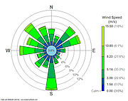
Wind rose
Encyclopedia

Wind
Wind is the flow of gases on a large scale. On Earth, wind consists of the bulk movement of air. In outer space, solar wind is the movement of gases or charged particles from the sun through space, while planetary wind is the outgassing of light chemical elements from a planet's atmosphere into space...
speed and direction are typically distributed at a particular location. Historically, wind roses were predecessors of the compass rose
Compass rose
A compass rose, sometimes called a windrose, is a figure on a compass, map, nautical chart or monument used to display the orientation of the cardinal directions — North, East, South and West - and their intermediate points. It is also the term for the graduated markings found on the traditional...
(found on map
Map
A map is a visual representation of an area—a symbolic depiction highlighting relationships between elements of that space such as objects, regions, and themes....
s), as there was no differentiation between a cardinal direction
Cardinal direction
The four cardinal directions or cardinal points are the directions of north, east, south, and west, commonly denoted by their initials: N, E, S, W. East and west are at right angles to north and south, with east being in the direction of rotation and west being directly opposite. Intermediate...
and the wind which blew from such a direction. Using a polar coordinate system
Polar coordinate system
In mathematics, the polar coordinate system is a two-dimensional coordinate system in which each point on a plane is determined by a distance from a fixed point and an angle from a fixed direction....
of gridding, the frequency of winds over a long time period are plotted by wind direction, with color bands showing wind ranges. The directions of the rose with the longest spoke show the wind direction with the greatest frequency.
History
Before the development of the compass roseCompass rose
A compass rose, sometimes called a windrose, is a figure on a compass, map, nautical chart or monument used to display the orientation of the cardinal directions — North, East, South and West - and their intermediate points. It is also the term for the graduated markings found on the traditional...
, a wind rose was included on maps in order to let the reader know which directions the 8 major winds (and sometimes 8 half winds and 16 quarter winds) blew within the plan view. No differentiation was made between cardinal directions and the winds which blew from said direction. North was depicted with a fleur de lis, while east was shown as a Christian cross
Christian cross
The Christian cross, seen as a representation of the instrument of the crucifixion of Jesus Christ, is the best-known religious symbol of Christianity...
to indicate the direction of Jerusalem from Europe
Europe
Europe is, by convention, one of the world's seven continents. Comprising the westernmost peninsula of Eurasia, Europe is generally 'divided' from Asia to its east by the watershed divides of the Ural and Caucasus Mountains, the Ural River, the Caspian and Black Seas, and the waterways connecting...
.
Use
Presented in a circular format, the modern wind rose shows the frequency of winds blowing from particular directions over a thirty year period. The length of each "spoke" around the circle is related to the frequency that the wind blows from a particular direction per unit time. Each concentric circle represents a different frequency, emanating from zero at the center to increasing frequencies at the outer circles. A wind rose plot may contain additional information, in that each spoke is broken down into color-coded bands that show wind speed ranges. Wind roses typically use 16 cardinal directions, such as north (N), NNE, NE, etc., although they may be subdivided into as many as 32 directions. In terms of angle measurement in degrees, North corresponds to 0°/360°, East to 90°, South to 180° and West to 270°.Compiling a wind rose is one of the preliminary steps taken in constructing airport
Airport
An airport is a location where aircraft such as fixed-wing aircraft, helicopters, and blimps take off and land. Aircraft may be stored or maintained at an airport...
runway
Runway
According to ICAO a runway is a "defined rectangular area on a land aerodrome prepared for the landing and take-off of aircraft." Runways may be a man-made surface or a natural surface .- Orientation and dimensions :Runways are named by a number between 01 and 36, which is generally one tenth...
s, as aircraft perform their best take-offs and landings pointing into the wind.

