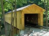
Windsor Mills Covered Bridge
Encyclopedia
Windsor Mills Bridge, also known as Wiswell Road Bridge or Warner Hollow Road Bridge, is a covered bridge
that carries Covered Bridge Lane, formerly Wiswell Road, across Phelps Creek in Windsor Township, Ashtabula County
, Ohio
, United States
. The bridge, one of currently 16 drivable bridges in the county, is a single-span Town truss design. The bridge sits atop cut stone abutments, one made of sandstone quarried nearby, and the other made of creek stone. The bridge was bypassed in the 1960s and closed to traffic, and Wiswell Road was rerouted west of the creek. In the 1980s, the bridge was completely closed due to safety reasons. It underwent extensive renovation from 2002 to 2004, and was then reopened to all traffic, except for trucks and buses. The bridge is listed in the National Register of Historic Places
. The bridge’s WGCB
number is 35-04-25, and it is located at 41°31′59.448"N 80°57′50.112"W (41.53318, 80.96392) approximately 5.0 mi (8.0 km) west of Orwell
.
Covered bridge
A covered bridge is a bridge with enclosed sides and a roof, often accommodating only a single lane of traffic. Most covered bridges are wooden; some newer ones are concrete or metal with glass sides...
that carries Covered Bridge Lane, formerly Wiswell Road, across Phelps Creek in Windsor Township, Ashtabula County
Ashtabula County, Ohio
Ashtabula County is the northeasternmost county in the state of Ohio. As of 2010, the population was 101,497, its county seat is Jefferson. The county is named for a Native American word meaning "river of many fish"....
, Ohio
Ohio
Ohio is a Midwestern state in the United States. The 34th largest state by area in the U.S.,it is the 7th‑most populous with over 11.5 million residents, containing several major American cities and seven metropolitan areas with populations of 500,000 or more.The state's capital is Columbus...
, United States
United States
The United States of America is a federal constitutional republic comprising fifty states and a federal district...
. The bridge, one of currently 16 drivable bridges in the county, is a single-span Town truss design. The bridge sits atop cut stone abutments, one made of sandstone quarried nearby, and the other made of creek stone. The bridge was bypassed in the 1960s and closed to traffic, and Wiswell Road was rerouted west of the creek. In the 1980s, the bridge was completely closed due to safety reasons. It underwent extensive renovation from 2002 to 2004, and was then reopened to all traffic, except for trucks and buses. The bridge is listed in the National Register of Historic Places
National Register of Historic Places
The National Register of Historic Places is the United States government's official list of districts, sites, buildings, structures, and objects deemed worthy of preservation...
. The bridge’s WGCB
World Guide to Covered Bridges
The World Guide to Covered Bridges is a covered bridge numbering system. The system was invented by John Diehl, the chairman of the Ohio Covered Bridge Committee. The committee first used the numbering system in 1953 to publish a list of covered bridges in Ohio....
number is 35-04-25, and it is located at 41°31′59.448"N 80°57′50.112"W (41.53318, 80.96392) approximately 5.0 mi (8.0 km) west of Orwell
Orwell, Ohio
Orwell is a village in Ashtabula County, Ohio, United States. The population was 1,519 at the 2000 census. It is the birthplace of General Adna Chaffee, and of Russell Allen, as of 2006 the oldest living American Olympic cyclist....
.
Directions to bridge
- From State Route 11, exit at U.S. Route 322 and head west approximately 12.9 miles.
- Turn left (south) on Warner Hollow Road (T-527) and continue 0.2 miles.
- Keep straight on old Wiswell Road to the bridge.
History
- 1867 – Bridge constructed.
- 2002-04 – Bridge renovated.
- 2004 – Bridge rededicated.

