Woronora Dam
Encyclopedia


Woronora River
The Woronora River flows north from near Helensburgh into the Georges River between Como and Illawong.- Crossings :The river is crossed by high level and low level road bridges and a footbridge in Woronora, New South Wales...
, which drains into the dam and then to Georges River
Georges River
The Georges River is a waterway in the state of New South Wales in Australia. It rises to the south-west of Sydney near the coal mining town of Appin, and then flows north past Campbelltown, roughly parallel to the Main South Railway...
. The dam supplies water to residents within the Sutherland Shire
Sutherland Shire
The Sutherland Shire is a Local Government Area in the Southern Sydney region of Sydney, Australia. Geographically, it is the area to the south of Botany Bay and the Georges River...
in Sydney's south and also the northern Illawarra
Illawarra
Illawarra is a region in the Australian state of New South Wales. It is a coastal region situated immediately south of Sydney and north of the Shoalhaven or South Coast region. It encompasses the cities of Wollongong, Shellharbour, Shoalhaven and the town of Kiama. The central region contains Lake...
suburbs of Helensburgh
Helensburgh
Helensburgh is a town in Argyll and Bute, Scotland. It lies on the north shore of the Firth of Clyde and the eastern shore of the entrance to the Gareloch....
, Otford
Otford
Otford is a village and civil parish in the Sevenoaks District of Kent known for its classically British countryside. The village is located on the River Darent, flowing north down its valley from its source on the North Downs...
, Stanwell Tops, Stanwell Park and Coalcliff.
Proposal and justification
Water was first supplied to Sutherland ShireSutherland Shire
The Sutherland Shire is a Local Government Area in the Southern Sydney region of Sydney, Australia. Geographically, it is the area to the south of Botany Bay and the Georges River...
in 1911 when a 150mm pipe was laid from Penshurst Reservoir across Georges River
Georges River
The Georges River is a waterway in the state of New South Wales in Australia. It rises to the south-west of Sydney near the coal mining town of Appin, and then flows north past Campbelltown, roughly parallel to the Main South Railway...
at Tom Ugly's Point to Miranda
Miranda, New South Wales
Miranda is a suburb in southern Sydney, in the state of New South Wales, Australia. Miranda is located 24 kilometres south of the Sydney central business district, in the Sutherland Shire....
.
In 1920 a scheme to supply water from the Woronora River
Woronora River
The Woronora River flows north from near Helensburgh into the Georges River between Como and Illawong.- Crossings :The river is crossed by high level and low level road bridges and a footbridge in Woronora, New South Wales...
to Sutherland
Sutherland, New South Wales
Sutherland is a suburb in southern Sydney, in the state of New South Wales, Australia. Sutherland is located 26 kilometres south of the Sydney central business district and is the administrative centre for the local government area of the Sutherland Shire....
and Cronulla was rejected. It was resurrected five years later when the then Metropolitan Water Sewerage and Drainage Board became the sole constructing authority for water supply works in the metropolitan area.
The scheme involved the construction of a dam
Dam
A dam is a barrier that impounds water or underground streams. Dams generally serve the primary purpose of retaining water, while other structures such as floodgates or levees are used to manage or prevent water flow into specific land regions. Hydropower and pumped-storage hydroelectricity are...
, which could be increased in size if necessary, on the Woronora River
Woronora River
The Woronora River flows north from near Helensburgh into the Georges River between Como and Illawong.- Crossings :The river is crossed by high level and low level road bridges and a footbridge in Woronora, New South Wales...
about 24km upstream of its junction with the Georges River
Georges River
The Georges River is a waterway in the state of New South Wales in Australia. It rises to the south-west of Sydney near the coal mining town of Appin, and then flows north past Campbelltown, roughly parallel to the Main South Railway...
.
Constructing Woronora Dam
Construction of the dam began in 1927, but as forecast, its size had to be increased two years later.Workers' accommodation was spartan but functional with small bungalow
Bungalow
A bungalow is a type of house, with varying meanings across the world. Common features to many of these definitions include being detached, low-rise , and the use of verandahs...
s built of fibrolite and placed on brick or concrete piers on the sloping ground. In 1930 The Depression intervened, suspending work on the dam. The men were forced to look for work further afield, even interstate, often leaving their families behind to live on the Woronora site.
Some families had strong ties to the history of Sydney's dams, moving from the Nepean Dam project to Woronora and then onto Warragamba
Warragamba Dam
Warragamba Dam is the primary water source for the Australian city of Sydney. It is approximately to the west of Sydney on the Warragamba River, a tributary of the Hawkesbury River, and impounds Lake Burragorang.- Overview :...
. Other workers on Woronora Dam were former coal miners from nearby Helensburgh
Helensburgh
Helensburgh is a town in Argyll and Bute, Scotland. It lies on the north shore of the Firth of Clyde and the eastern shore of the entrance to the Gareloch....
.
Late in 1931 the Unemployment Relief Account released funds to build a weir to provide water to the Sutherland-Cronulla area and four years later, work resumed on the dam itself.
Woronora Dam was completed in 1941 at a cost of about $13 million. Six of the cottages were retained for on-site maintenance staff housing while the rest of Woronora township site was turned into picnic and recreational areas.
Features of Woronora Dam
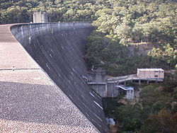
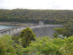
Woronora Dam is curved in appearance and is a mass gravity dam, remaining in position under its own weight. Its lower levels are built of cyclopean masonry - massive sandstone blocks that were quarried on site. The main wall is made from blue metal and gravel concreteConcrete
Concrete is a composite construction material, composed of cement and other cementitious materials such as fly ash and slag cement, aggregate , water and chemical admixtures.The word concrete comes from the Latin word...
and there are two inspection galleries located inside.
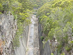
The dam has a separate, serpentine spillway that discharges floodwater through a concrete lined cutting into the river downstream of the dam.
In 1988 Woronora Dam was upgraded at a cost of $2.9m by a system of wall and foundation drains to meet international dam safety standards.
Raw water from Woronora Dam is pumped to the adjacent Woronora Water Filtration Plant. This plant is one of nine in Sydney
Sydney
Sydney is the most populous city in Australia and the state capital of New South Wales. Sydney is located on Australia's south-east coast of the Tasman Sea. As of June 2010, the greater metropolitan area had an approximate population of 4.6 million people...
either operated by Sydney Water
Sydney Water
Sydney Water is a New South Wales government owned corporation that provides drinking water, wastewater and some stormwater services to Sydney, Illawarra and the Blue Mountains, in Australia...
or privately owned and operated under contract to Sydney Water
Sydney Water
Sydney Water is a New South Wales government owned corporation that provides drinking water, wastewater and some stormwater services to Sydney, Illawarra and the Blue Mountains, in Australia...
. The dam and water filtration plant supply water to the areas south of the Georges River including Sutherland
Sutherland, New South Wales
Sutherland is a suburb in southern Sydney, in the state of New South Wales, Australia. Sutherland is located 26 kilometres south of the Sydney central business district and is the administrative centre for the local government area of the Sutherland Shire....
, Helensburgh
Helensburgh
Helensburgh is a town in Argyll and Bute, Scotland. It lies on the north shore of the Firth of Clyde and the eastern shore of the entrance to the Gareloch....
, Stanwell Park, Lucas Heights and Bundeena.
- HeightHeightHeight is the measurement of vertical distance, but has two meanings in common use. It can either indicate how "tall" something is, or how "high up" it is. For example "The height of the building is 50 m" or "The height of the airplane is 10,000 m"...
: 66 metres - LengthLengthIn geometric measurements, length most commonly refers to the longest dimension of an object.In certain contexts, the term "length" is reserved for a certain dimension of an object along which the length is measured. For example it is possible to cut a length of a wire which is shorter than wire...
: 390 metres - Capacity: 71,790 megalitres
- Catchment areaDrainage basinA drainage basin is an extent or an area of land where surface water from rain and melting snow or ice converges to a single point, usually the exit of the basin, where the waters join another waterbody, such as a river, lake, reservoir, estuary, wetland, sea, or ocean...
: 75 square kilometres - ReservoirReservoirA reservoir , artificial lake or dam is used to store water.Reservoirs may be created in river valleys by the construction of a dam or may be built by excavation in the ground or by conventional construction techniques such as brickwork or cast concrete.The term reservoir may also be used to...
: 4 square kilometres
The Maritime Operations Division within the Department of Defence
Department of Defence (Australia)
The Australian Department of Defence is a Federal Government Department. It forms part of the Australian Defence Organisation along with the Australian Defence Force . The Defence mission is to defend Australia and its national interests...
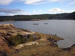
uses Woronora Dam to test its sonar
Sonar
Sonar is a technique that uses sound propagation to navigate, communicate with or detect other vessels...
facilities. The testing station is on a pontoon
Pontoon (boat)
A pontoon is a flotation device with buoyancy sufficient to float itself as well as a heavy load. A pontoon boat is a flattish boat that relies on pontoons to float. Pontoons may be used on boats, rafts, barges, docks, floatplanes or seaplanes. Pontoons may support a platform, creating a raft. A...
in the middle of the reservoir. The building of the Woronora Dam became part of the backdrop of the comedy drama "Dad Rudd MP". The film features several construction scenes and employed many workers and their families as 'extras'.
The dam can be viewed by the public, and has a walking trail across the dam wall, and a picnic area including a carpark. Woronora Dam Road leads from the Princes Highway
Princes Highway
The Princes Highway extends from Sydney to Port Augusta via the coast through the states of New South Wales, Victoria and South Australia, a distance of 1941 km or 1898 km via the former alignments of the highway ....
for seven kilometers to the dam.

