Yarra Bend Park, Melbourne
Encyclopedia

Melbourne
Melbourne is the capital and most populous city in the state of Victoria, and the second most populous city in Australia. The Melbourne City Centre is the hub of the greater metropolitan area and the Census statistical division—of which "Melbourne" is the common name. As of June 2009, the greater...
suburb of Kew
Kew, Victoria
Kew is a suburb in Melbourne, Victoria, Australia, 6 km east from Melbourne's central business district. Its Local Government Area is the City of Boroondara. At the 2006 Census, Kew had a population of 22,516....
. Located 4 km northeast of Melbourne's CBD, it is the largest area of natural bushland left in inner Melbourne. The most notable feature of the park is the Yarra River
Yarra River
The Yarra River, originally Birrarung, is a river in east-central Victoria, Australia. The lower stretches of the river is where the city of Melbourne was established in 1835 and today Greater Melbourne dominates and influences the landscape of its lower reaches...
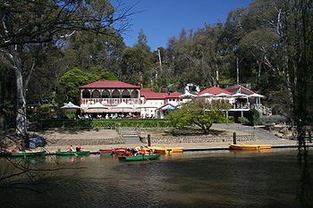
which flows for 12 km through it. The park hosts two golf courses, two historic boathouses, sheds and a number of cycle and walking trails. It receives approximately 1.5 million visitors per year.
History
The park's location at the joining of the Yarra River and Merri CreekMerri Creek
The Merri Creek is a waterway in southern parts of Victoria, Australia which flows through the northern suburbs of Melbourne. It begins in Wallan north of Melbourne and flows south for 70km until it joins the Yarra River at Dights Falls...
has been an important site for the Wurundjeri
Wurundjeri
The Wurundjeri are a people of the Indigenous Australian nation of the Woiwurrung language group, in the Kulin alliance, who occupy the Birrarung Valley, its tributaries and the present location of Melbourne, Australia...
Aboriginal
Indigenous Australians
Indigenous Australians are the original inhabitants of the Australian continent and nearby islands. The Aboriginal Indigenous Australians migrated from the Indian continent around 75,000 to 100,000 years ago....
people for a long time prior to the arrival of Europeans in Melbourne, which is commemorated by the Koori Garden on the western edge of the park, near Dights Falls
Dights Falls
Dights Falls is located in Melbourne, Victoria just downstream of the junction of the Yarra River with Merri Creek. At this point the river narrows and is constricted between 800,000 year old volcanic, basaltic lava flow and a much older steep, silurian, sedimentary spur...
. Yarra Bend Park was officially reserved in 1877, and in 1929 it joined with Studley Park to the south to cover the whole of the area today. From 1848 until 1925 the park was home to Yarra Bend Lunatic Asylum
Yarra Bend Asylum
Yarra Bend Asylum was the first permanent institution established in Victoria that was devoted to the treatment of the mentally ill. It opened in 1848 as a ward of the Asylum at Tarban Creek in New South Wales. It was not officially called Yarra Bend Asylum until July 1851 when the Port Phillip...
, which took up most of the area of the park with buildings, vegetable gardens and a cemetery.
In 1904, the Queen’s Memorial Infectious Diseases Hospital
Fairfield Infectious Diseases Hospital
Fairfield Infectious Diseases Hospital, originally known as Queens Memorial Infectious Diseases Hospital, operated from 1904 to its closure in 1996. Perched high on the banks of the Yarra River at Yarra Bend in the inner Melbourne suburb of Fairfield, it developed an international reputation for...
was established along Yarra Bend Road, Fairfield. Later simply known as "Fairfield Hospital", it closed in 1996. The southern portion of the site now accommodates the Thomas Embling Hospital, opened by the Victorian Institute of Forensic Mental Health in April 2000, with the majority of the buildings in the northern portion converted for use by NMIT Fairfield
Northern Melbourne Institute of TAFE
Northern Melbourne Institute of TAFE is a TAFE institute located in the northern suburbs of Melbourne, Victoria, Australia. It has six city campuses located at Preston, Collingwood, Epping, Fairfield, Greensborough, Heidelberg, a country campus at Ararat, and country training facilities at Eden...
.
The Mission of St James and St John opened a Venereal Disease Clinic named
“Fairhaven” in 1927 on the northern section of land previously occupied by the Yarra Bend Asylum, including the asylum's main buildings. The clinic closed in 1951 and the site was temporarily used by the adjacent Fairfield Hospital as staff quarters and storerooms.
In 1953, the former “Fairhaven” site was acquired by the Prisons Division for conversion
into a female prison. HM Prison Fairlea
HM Prison Fairlea
HM Prison Fairlea was an Australian female prison located on Yarra Bend Road in the suburb of Fairfield, Victoria, Australia. The first all-female prison in Victoria, it was built on the site of the Yarra Bend Asylum, with remnants of the walls and gates being used in the layout of the prison. In...
was officially opened in 1956 and
closed in August 1996.
In 1972 the Eastern Freeway was constructed through the middle of the park, crossing both the Merri Creek
Merri Creek
The Merri Creek is a waterway in southern parts of Victoria, Australia which flows through the northern suburbs of Melbourne. It begins in Wallan north of Melbourne and flows south for 70km until it joins the Yarra River at Dights Falls...
and the Yarra River
Yarra River
The Yarra River, originally Birrarung, is a river in east-central Victoria, Australia. The lower stretches of the river is where the city of Melbourne was established in 1835 and today Greater Melbourne dominates and influences the landscape of its lower reaches...
. Parts of the Yarra were relocated and the Deep Rock Basin was completely demolished. This was highly controversial at the time, heightened by the destruction of rich history of not only Wurundjeri
Wurundjeri
The Wurundjeri are a people of the Indigenous Australian nation of the Woiwurrung language group, in the Kulin alliance, who occupy the Birrarung Valley, its tributaries and the present location of Melbourne, Australia...
origin but European as well.
Things to do
There are a number of shared use tracks for cyclists and pedestrians. The Capital City TrailCapital City Trail
The Capital City Trail is a shared use path for cyclists and pedestrians, which circles the Melbourne city centre and some inner eastern and northern suburbs of Melbourne, Victoria, Australia....
and Yarra River Trail both pass through the park. Organised bushwalking and birdwatching tours are available and there is even a tour to the Flying Fox
Pteropus
Bats of the genus Pteropus, belonging to the megabat or Megachiroptera sub-order, are the largest bats in the world. They are commonly known as the fruit bats or flying foxes among other colloquial names...
colony. Some areas of the park are designated Dog Exclusion zones but dogs can be walked in On Lead and Off Lead zones. Canoes and boats can be hired from the Studley Park Boathouse. Fishing is possible in the rivers.
There are a number of sports grounds including the Corben Oval, W.T. Long Oval, Sir Herbert Olney Oval, Westfield South Oval and Westfield North Oval. The Fairlea West Oval, Fairlea East Oval and W.J. Cox Oval synthetic pitches can be hired for social matches.
There are several picnic areas with electric barbecues and toilets. Westfield, North Rotunda and South Rotunda shelters close to picnic facilities can be hired, as can the grassed picnic areas at Deep Rock and Loop Road. Studley Park and Bellbird picnic areas are also available for public use.
A world class fly-casting pool is located (since 1978) beside the Fairlea East Oval.
Regular fly casting tournaments, local and intrastate take place here particularly during the winter months.
Wildlife
The park is home to many species of birds, mammals, reptiles, insects and fish, including Rainbow LorikeetRainbow Lorikeet
The Rainbow Lorikeet, is a species of Australasian parrot found in Australia, eastern Indonesia , Papua New Guinea, New Caledonia, Solomon Islands and Vanuatu. In Australia, it is common along the eastern seaboard, from Queensland to South Australia and northwest Tasmania...
s, Red-rumped Parrot
Red-rumped Parrot
The Red-rumped Parrot , also known as the Red-backed Parrot or Grass Parrot, is a common bird of south-eastern Australia, particularly in the Murray-Darling Basin.-Description:...
s and Yellow-tailed Black Cockatoo
Yellow-tailed Black Cockatoo
The Yellow-tailed Black Cockatoo is a large cockatoo native to the south-east of Australia measuring 55–65 cm in length. It has a short crest on the top of its head. Its plumage is mostly brownish black and it has prominent yellow cheek patches and a yellow tail band...
s, Water Rat
Water Rat
Water Rat may refer to:AnimalsWater Rat is a common name for several unrelated semiaquatic rodents, including:*European Water Vole, found in north and central Europe and Russia*Rakali, found in Australia and New Guinea...
s and Brush-tail and Ringtail Possum
Possum
A possum is any of about 70 small to medium-sized arboreal marsupial species native to Australia, New Guinea, and Sulawesi .Possums are quadrupedal diprotodont marsupials with long tails...
s.
Yarra Bend Park is also home to a colony of Grey-headed Flying Fox
Grey-headed Flying Fox
The Grey-headed Flying-Fox, Pteropus poliocephalus, is a megabat native to Australia.Members of the genus Pteropus include the largest bats in the world. The Pteropus genus has currently about 57 recognised species....
es. The colony took up residence in the Royal Botanic Gardens
Royal Botanic Gardens, Melbourne
The Royal Botanic Gardens Melbourne are internationally renowned botanical gardens located near the centre of Melbourne, Victoria, Australia, on the south bank of the Yarra River. They are 38 hectares of landscaped gardens consisting of a mix of native and non-native vegetation including over...
in 1986. The population varied in size from 6000 to 20,000. Because of the damage the flying foxes were causing to trees, the colony was relocated to Yarra Bend Park in 2003.
Golf courses
Inside the park are two golf courses: the 18 hole Yarra Bend Golf Course, bounded by the Yarra River and the Eastern Freeway, and the 9 hole Studley Park Golf Course in the south of the park. Yarra Bend Golf Course is par 70, ACR (Australian Course Rating) 68.6 and total course length is 5538m. Studley Park Golf Course is par 27 and the total course length is 1196m.Visitor information
Opening hoursThe park is open to pedestrians 24 hours a day (access for vehicles is 8am until late) every day of the year.
Transport
Vehicle entrances are at Studley Park Road and Yarra Boulevard, Kew, or Yarra Bend Road, Fairfield. The park is on the route of the following buses: 201, 203-206, 277, 278, 300, 301 and 546.

