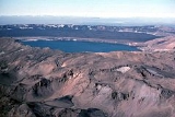
Öskjuvatn
Encyclopedia
Öskjuvatn is a lake
in the Highlands of Iceland
. Its surface area is about 11 km². With a depth of 217 m (712 ft), it is the deepest lake in Iceland
.
The lake is situated in the crater
of the volcano
Askja
in the north-east of the glacier Vatnajökull
. Its name simply means the lake of Askja. Like the neighbouring crater Víti
, it was created by an enormous volcanic eruption in 1875.
On July 10, 1907, two German scientists, Walter von Knebel and Max Rudloff disappeared while exploring the lake in a small boat. Knebel's fiancée, Ina von Grumbkow, led an expedition in search of them, but no trace of them was ever found. Suppositions at the time suggested that seismic volcanic disturbances could have caused a landslip or similar occurrence, and recorded that only two days previously the telegraph cable to Iceland had been broken by deep water disturbances for the first time since it was laid, close to the Icelandic coast.
Lake
A lake is a body of relatively still fresh or salt water of considerable size, localized in a basin, that is surrounded by land. Lakes are inland and not part of the ocean and therefore are distinct from lagoons, and are larger and deeper than ponds. Lakes can be contrasted with rivers or streams,...
in the Highlands of Iceland
Highlands of Iceland
The Highlands of Iceland cover most of the interior of Iceland. They are situated above 400–500 metres and are mostly an uninhabitable volcanic desert, because the water precipitating as rain or snow infiltrates so quickly into the ground that it is unavailable for plant growth, which results...
. Its surface area is about 11 km². With a depth of 217 m (712 ft), it is the deepest lake in Iceland
Iceland
Iceland , described as the Republic of Iceland, is a Nordic and European island country in the North Atlantic Ocean, on the Mid-Atlantic Ridge. Iceland also refers to the main island of the country, which contains almost all the population and almost all the land area. The country has a population...
.
The lake is situated in the crater
Volcanic crater
A volcanic crater is a circular depression in the ground caused by volcanic activity. It is typically a basin, circular in form within which occurs a vent from which magma erupts as gases, lava, and ejecta. A crater can be of large dimensions, and sometimes of great depth...
of the volcano
Volcano
2. Bedrock3. Conduit 4. Base5. Sill6. Dike7. Layers of ash emitted by the volcano8. Flank| 9. Layers of lava emitted by the volcano10. Throat11. Parasitic cone12. Lava flow13. Vent14. Crater15...
Askja
Askja
Askja is a stratovolcano situated in a remote part of the central highlands of Iceland. The name Askja refers to a complex of nested calderas within the surrounding Dyngjufjöll mountains, which rise to , askja meaning box or caldera in Icelandic-Location:The region is only accessible for a few...
in the north-east of the glacier Vatnajökull
Vatnajökull
Vatnajökull is the largest glacier in Iceland. It is located in the south-east of the island, covering more than 8% of the country.-Size:With an area of 8,100 km², Vatnajökull is the largest ice cap in Europe by volume and the second largest in area Vatnajökull is the largest glacier in...
. Its name simply means the lake of Askja. Like the neighbouring crater Víti
Askja
Askja is a stratovolcano situated in a remote part of the central highlands of Iceland. The name Askja refers to a complex of nested calderas within the surrounding Dyngjufjöll mountains, which rise to , askja meaning box or caldera in Icelandic-Location:The region is only accessible for a few...
, it was created by an enormous volcanic eruption in 1875.
On July 10, 1907, two German scientists, Walter von Knebel and Max Rudloff disappeared while exploring the lake in a small boat. Knebel's fiancée, Ina von Grumbkow, led an expedition in search of them, but no trace of them was ever found. Suppositions at the time suggested that seismic volcanic disturbances could have caused a landslip or similar occurrence, and recorded that only two days previously the telegraph cable to Iceland had been broken by deep water disturbances for the first time since it was laid, close to the Icelandic coast.
See also
- Geography of IcelandGeography of IcelandIceland is a medium-sized island in the North Atlantic ocean. The island is located east of Greenland and immediately south of the Arctic Circle, atop the divergent boundary of the Mid-Atlantic Ridge in the North Atlantic Ocean. It lies about from New York City and from Scotland...
- Glaciers of IcelandGlaciers of IcelandThe glaciers and ice caps of Iceland cover 11.1% of the land area of the country and have a considerable impact on its landscape and meteorology...
- Iceland plumeIceland plumeThe Iceland Plume is a postulated upwelling of anomalously hot rock in the Earth's mantle beneath Iceland. Its origin is thought to lie deep in the mantle, perhaps at the boundary between the core and the mantle at ca. 2880 km depth. Opinions differ as to whether seismic studies have imaged...
- Lakes of Iceland
- List of islands off Iceland
- List of volcanoes in Iceland
- Rivers of Iceland
- Volcanism in Iceland
- Waterfalls of IcelandWaterfalls of IcelandIceland is unusually suited for waterfalls. This small island country has a north Atlantic climate that produces frequent rain or snow and a near-Arctic location that produces large glaciers, whose summer melts feed many rivers...
- Geographical Journal Jan 1910

