
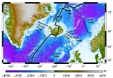
Iceland plume
Encyclopedia
The Iceland Plume
is a postulated upwelling of anomalously hot rock in the Earth's mantle beneath Iceland
. Its origin is thought to lie deep in the mantle, perhaps at the boundary between the core and the mantle at ca. 2880 km depth. Opinions differ as to whether seismic studies have imaged such a structure . In this framework, the volcanism of Iceland is attributed to this plume, according to the theory of W. Jason Morgan
. Alternatively, the volcanism of Iceland has been attributed to postulated enhanced fertility at this part of the spreading plate boundary.
and early Eocene
, which has led to suggestions that the arrival of the plume was linked to, and was perhaps contributed to the breakup of the North Atlantic continent. In the framework of the plume hypothesis, the volcanism was caused by the flow of hot plume material initially beneath thick continental lithosphere and then as rifting proceeded into beneath the lithosphere of the growing ocean basin. The exact position of the plume at that time is a matter of disagreement between scientists, but was probably beneath central Greenland;, as is whether the plume is thought to have ascended from the deep mantle only at that time or whether it is much older and also responsible for the old volcanism in northern Greenland, the Ellesmere Island Volcanics
on Ellesmere Island
, and in the Arctic Ocean
(Alpha Ridge
).
As the northern Atlantic opened to the east of Greenland during the Eocene, North America and Eurasia drifted apart; the Mid-Atlantic Ridge
formed as an oceanic spreading center and a part of the submarine volcanic system of mid-oceanic ridges. The initial plume may have been several thousand kilometers in diameter and it erupted volcanic rocks on both sides of the present ocean basin to produce the North Atlantic Igneous Province. Upon further opening of the ocean and plate drift, the plume and the mid-Atlantic Ridge are postulated to have approached one another, and finally met. The excess magmatism that accompanied the transition from flood volcanism on Greenland, Ireland and Norway to present-day Icelandic activity was the result of ascent of the hot mantle source beneath progressively thinning lithosphere, according to the plume model, or a postulated unusually productive part of the mid-ocean ridge system.
An extinct ridge exists in western Iceland, leading to the theory that the plume has shifted east with time. The oldest crust of Iceland itself is more than 20 million years old and was formed at an old, now extinct oceanic spreading center in the western fjord (Vestfirðir) region. The westward movement of the plates and the ridge above the plume and the strong thermal anomaly of the latter caused this old spreading center to starve 15 million years ago and lead to the formation of a new one in the area of today's peninsulas Skagi and Snæfellsnes; in the latter there is still some activity in the form of the Snæfellsjökull volcano. The spreading center, and hence the main activity, have shifted eastward again 7–9 million years ago, however, and formed the current volcanic zones in the southwest (WVZ; Reykjanes
–Hofsjökull
–Vatnajökull
) and northeast (NVZ; Vatnajökull
–Tjörnes). Presently, a slow decrease of the activity in the WVZ takes place, while the volcanic zone in the southeast (Katla
–Vatnajökull
), which was initiated 3 million years ago, develops. The reorganisation of the plate boundaries in Iceland has also been attributed to microplate tectonics.
, geoid
and in particular seismological
methods along with geochemical analyses of erupted lavas have proven especially useful. Numerical models of the geodynamical processes attempt to merge these observations into a consistent general picture.
, by which the area under consideration is “illuminated” from all sides with seismic waves from earthquake
s from as many different directions as possible; these waves are recorded with a network of seismometer
s. The size of the network is crucial for the extent of the region which can be imaged reliably. For the investigation of the Iceland Plume both global and regional tomography have been used; in the former, the whole mantle is imaged at relatively low resolution using data from stations all over the world, whereas in the latter, a denser network only on Iceland images the mantle down to 400–450 km depth with higher resolution.
Regional studies from the 1990s and 2000s (ICEMELT, HOTSPOT) show that there is a low seismic-wave-speed anomaly beneath Iceland but opinion is divided as to whether it continues deeper than the mantle transition zone at roughly 600 km depth. The velocities of seismic waves are reduced by up to 3% (P waves) and more than 4% (S waves), respectively. These values are consistent with a small percentage of partial melt, a high Mg content of the mantle, or elevated temperature. Unfortunately it is not possible to unambiguously separate out which effect causes the observed velocity reduction.
, but also eclogite
- a fertile rock originating from subducted slabs - contribute to the melts. The origin of the latter is assumed to be metamorphosed, very old oceanic crust which sank into the mantle several hundreds of millions of years ago during the subduction of an ocean, then upwelled from deep in the mantle.
Using the major and trace-element compositions of Icelandic volcanics showed that the source of present-day volcanism was about 100°C greater than that of the source of mid-ocean ridge basalts.
The variations in the concentrations of trace elements such as helium
, lead
, strontium
, neodymium
, and others show clearly that Iceland is compositionally distinct from the rest of the north Atlantic. For instance, the ratio of He-3 and He-4 has a pronounced maximum on Iceland, which correlates well with geophysical anomalies, and the decrease of this and other geochemical signatures with increasing distance from Iceland indicate that the extent of the compositional anomaly reaches about 1500 km along the Reykjanes Ridge and at least 300 km along the Kolbeinsey
Ridge. Depending on which elements are considered and how large the area covered is, one can identify up to six different mantle components, which, however, are not all present in any single location.
Furthermore, some studies show that the amount of water dissolved in mantle minerals is two to six times higher in the Iceland region than in undisturbed parts of the mid-oceanic ridges, where it is regarded to lie at about 150 ppm. The presence of such a large amount of water in the source of the lavas would tend to lower its melting point and make it more productive of magma for a given temperature.
. The geoid rises up to 70 m above the geodetic reference ellipsoid in an approximately circular area with a diameter of several hundred kilometers. In the context of the plume hypothesis, this has been explained by the dynamic effect of the upwelling plume which bulges up the surface of the Earth. Furthermore, the plume and the thickened crust cause a positive gravity anomaly of about 60 mGal (=0.0006 m/s²) (free-air).
. The purpose of these calculations was, among other things, to resolve the paradox that a broad plume with a relatively low temperature anomaly is in better agreement with observed crustal thickness, topography, and gravity, whereas a thin hot plume which has been invoked to explain seismological and geochemical observations. The most recent models prefer a model for a plume that is 180–200°C hotter than the surrounding mantle and has a stem with a radius of ca. 100 km. Such temperatures have not yet been confirmed by petrology, however.
and therefore also restricted to the upper 200–300 km of the mantle. However, this convection mechanism is probably not strong enough under the conditions prevailing in the north Atlantic, e.g. with respect to the spreading rate, and it does not offer a simple explanation for the observed geoid anomaly.
Mantle plume
A mantle plume is a hypothetical thermal diapir of abnormally hot rock that nucleates at the core-mantle boundary and rises through the Earth's mantle. Such plumes were invoked in 1971 to explain volcanic regions that were not thought to be explicable by the then-new theory of plate tectonics. Some...
is a postulated upwelling of anomalously hot rock in the Earth's mantle beneath Iceland
Iceland
Iceland , described as the Republic of Iceland, is a Nordic and European island country in the North Atlantic Ocean, on the Mid-Atlantic Ridge. Iceland also refers to the main island of the country, which contains almost all the population and almost all the land area. The country has a population...
. Its origin is thought to lie deep in the mantle, perhaps at the boundary between the core and the mantle at ca. 2880 km depth. Opinions differ as to whether seismic studies have imaged such a structure . In this framework, the volcanism of Iceland is attributed to this plume, according to the theory of W. Jason Morgan
W. Jason Morgan
William Jason Morgan is an American geophysicist who has made seminal contributions to the theory of plate tectonics and geodynamics...
. Alternatively, the volcanism of Iceland has been attributed to postulated enhanced fertility at this part of the spreading plate boundary.
Geological history
According to the plume model, the source of Icelandic volcanism lies deep beneath the center of the island. The earliest volcanic rocks attributed to the plume are found on both sides of the Atlantic. Their ages have been determined to lie between 58 and 64 million years. This coincides with the opening of the north Atlantic in the late PaleocenePaleocene
The Paleocene or Palaeocene, the "early recent", is a geologic epoch that lasted from about . It is the first epoch of the Palaeogene Period in the modern Cenozoic Era...
and early Eocene
Eocene
The Eocene Epoch, lasting from about 56 to 34 million years ago , is a major division of the geologic timescale and the second epoch of the Paleogene Period in the Cenozoic Era. The Eocene spans the time from the end of the Palaeocene Epoch to the beginning of the Oligocene Epoch. The start of the...
, which has led to suggestions that the arrival of the plume was linked to, and was perhaps contributed to the breakup of the North Atlantic continent. In the framework of the plume hypothesis, the volcanism was caused by the flow of hot plume material initially beneath thick continental lithosphere and then as rifting proceeded into beneath the lithosphere of the growing ocean basin. The exact position of the plume at that time is a matter of disagreement between scientists, but was probably beneath central Greenland;, as is whether the plume is thought to have ascended from the deep mantle only at that time or whether it is much older and also responsible for the old volcanism in northern Greenland, the Ellesmere Island Volcanics
Ellesmere Island Volcanics
The Ellesmere Island Volcanics are a Late Cretaceous volcanic group of volcanoes and lava flows in the Qikiqtaaluk Region of northern Ellesmere Island, Nunavut, Canada.Ellesmere Island Volcanics are part of the Arctic Cordillera...
on Ellesmere Island
Ellesmere Island
Ellesmere Island is part of the Qikiqtaaluk Region of the Canadian territory of Nunavut. Lying within the Canadian Arctic Archipelago, it is considered part of the Queen Elizabeth Islands, with Cape Columbia being the most northerly point of land in Canada...
, and in the Arctic Ocean
Arctic Ocean
The Arctic Ocean, located in the Northern Hemisphere and mostly in the Arctic north polar region, is the smallest and shallowest of the world's five major oceanic divisions...
(Alpha Ridge
Alpha Ridge
The Alpha Ridge is a major volcanic ridge under the Arctic Ocean between the Canada Basin and the Lomonosov Ridge. It was active during the formation of the Amerasian Basin. It was discovered in 1963. The highest elevation is about 2.7 km over the ocean floor. It is 200 to 450 km wide...
).
As the northern Atlantic opened to the east of Greenland during the Eocene, North America and Eurasia drifted apart; the Mid-Atlantic Ridge
Mid-Atlantic Ridge
The Mid-Atlantic Ridge is a mid-ocean ridge, a divergent tectonic plate boundary located along the floor of the Atlantic Ocean, and part of the longest mountain range in the world. It separates the Eurasian Plate and North American Plate in the North Atlantic, and the African Plate from the South...
formed as an oceanic spreading center and a part of the submarine volcanic system of mid-oceanic ridges. The initial plume may have been several thousand kilometers in diameter and it erupted volcanic rocks on both sides of the present ocean basin to produce the North Atlantic Igneous Province. Upon further opening of the ocean and plate drift, the plume and the mid-Atlantic Ridge are postulated to have approached one another, and finally met. The excess magmatism that accompanied the transition from flood volcanism on Greenland, Ireland and Norway to present-day Icelandic activity was the result of ascent of the hot mantle source beneath progressively thinning lithosphere, according to the plume model, or a postulated unusually productive part of the mid-ocean ridge system.
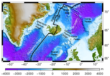
An extinct ridge exists in western Iceland, leading to the theory that the plume has shifted east with time. The oldest crust of Iceland itself is more than 20 million years old and was formed at an old, now extinct oceanic spreading center in the western fjord (Vestfirðir) region. The westward movement of the plates and the ridge above the plume and the strong thermal anomaly of the latter caused this old spreading center to starve 15 million years ago and lead to the formation of a new one in the area of today's peninsulas Skagi and Snæfellsnes; in the latter there is still some activity in the form of the Snæfellsjökull volcano. The spreading center, and hence the main activity, have shifted eastward again 7–9 million years ago, however, and formed the current volcanic zones in the southwest (WVZ; Reykjanes
Reykjanes
Reykjanes or Reykjanesskagi is a peninsula and a volcanic system situated at the south-western end of Iceland, near the capital of Reykjavík....
–Hofsjökull
Hofsjökull
Hofsjökull is the third largest glacier in Iceland after Vatnajökull and Langjökull and the largest active volcano in the country. It situates at the west of the Highlands of Iceland and north of the mountain range Kerlingarfjöll, between the two largest glaciers of Iceland. It covers an area of...
–Vatnajökull
Vatnajökull
Vatnajökull is the largest glacier in Iceland. It is located in the south-east of the island, covering more than 8% of the country.-Size:With an area of 8,100 km², Vatnajökull is the largest ice cap in Europe by volume and the second largest in area Vatnajökull is the largest glacier in...
) and northeast (NVZ; Vatnajökull
Vatnajökull
Vatnajökull is the largest glacier in Iceland. It is located in the south-east of the island, covering more than 8% of the country.-Size:With an area of 8,100 km², Vatnajökull is the largest ice cap in Europe by volume and the second largest in area Vatnajökull is the largest glacier in...
–Tjörnes). Presently, a slow decrease of the activity in the WVZ takes place, while the volcanic zone in the southeast (Katla
Katla
Katla is one of the largest volcanoes in Iceland. It is situated to the north of Vík í Mýrdal and to the east of the smaller glacier Eyjafjallajökull. Its peak reaches in height and is partially covered by the Mýrdalsjökull glacier. The Eldgjá canyon is part of the same volcanic system...
–Vatnajökull
Vatnajökull
Vatnajökull is the largest glacier in Iceland. It is located in the south-east of the island, covering more than 8% of the country.-Size:With an area of 8,100 km², Vatnajökull is the largest ice cap in Europe by volume and the second largest in area Vatnajökull is the largest glacier in...
), which was initiated 3 million years ago, develops. The reorganisation of the plate boundaries in Iceland has also been attributed to microplate tectonics.
Geophysical and geochemical observations
Information about the structure of Earth's deep interior can be acquired only indirectly by geophysical and geochemical methods. For the investigation of postulated plumes, gravimetricGravimetry
Gravimetry is the measurement of the strength of a gravitational field. Gravimetry may be used when either the magnitude of gravitational field or the properties of matter responsible for its creation are of interest...
, geoid
Geoid
The geoid is that equipotential surface which would coincide exactly with the mean ocean surface of the Earth, if the oceans were in equilibrium, at rest , and extended through the continents . According to C.F...
and in particular seismological
Seismology
Seismology is the scientific study of earthquakes and the propagation of elastic waves through the Earth or through other planet-like bodies. The field also includes studies of earthquake effects, such as tsunamis as well as diverse seismic sources such as volcanic, tectonic, oceanic,...
methods along with geochemical analyses of erupted lavas have proven especially useful. Numerical models of the geodynamical processes attempt to merge these observations into a consistent general picture.
Seismology
An important method for imaging large-scale structures in Earth's interior is seismic tomographyTomography
Tomography refers to imaging by sections or sectioning, through the use of any kind of penetrating wave. A device used in tomography is called a tomograph, while the image produced is a tomogram. The method is used in radiology, archaeology, biology, geophysics, oceanography, materials science,...
, by which the area under consideration is “illuminated” from all sides with seismic waves from earthquake
Earthquake
An earthquake is the result of a sudden release of energy in the Earth's crust that creates seismic waves. The seismicity, seismism or seismic activity of an area refers to the frequency, type and size of earthquakes experienced over a period of time...
s from as many different directions as possible; these waves are recorded with a network of seismometer
Seismometer
Seismometers are instruments that measure motions of the ground, including those of seismic waves generated by earthquakes, volcanic eruptions, and other seismic sources...
s. The size of the network is crucial for the extent of the region which can be imaged reliably. For the investigation of the Iceland Plume both global and regional tomography have been used; in the former, the whole mantle is imaged at relatively low resolution using data from stations all over the world, whereas in the latter, a denser network only on Iceland images the mantle down to 400–450 km depth with higher resolution.
Regional studies from the 1990s and 2000s (ICEMELT, HOTSPOT) show that there is a low seismic-wave-speed anomaly beneath Iceland but opinion is divided as to whether it continues deeper than the mantle transition zone at roughly 600 km depth. The velocities of seismic waves are reduced by up to 3% (P waves) and more than 4% (S waves), respectively. These values are consistent with a small percentage of partial melt, a high Mg content of the mantle, or elevated temperature. Unfortunately it is not possible to unambiguously separate out which effect causes the observed velocity reduction.
Geochemistry
Numerous studies have addressed the geochemical signature of the lavas present on Iceland and in the north Atlantic. The resulting picture is consistent in several important respects. For instance, it is not contested that the source of the volcanism in the mantle is chemically and petrologically heterogeneous: it contains not only normal peridotitePeridotite
A peridotite is a dense, coarse-grained igneous rock, consisting mostly of the minerals olivine and pyroxene. Peridotite is ultramafic, as the rock contains less than 45% silica. It is high in magnesium, reflecting the high proportions of magnesium-rich olivine, with appreciable iron...
, but also eclogite
Eclogite
Eclogite is a mafic metamorphic rock. Eclogite is of special interest for at least two reasons. First, it forms at pressures greater than those typical of the crust of the Earth...
- a fertile rock originating from subducted slabs - contribute to the melts. The origin of the latter is assumed to be metamorphosed, very old oceanic crust which sank into the mantle several hundreds of millions of years ago during the subduction of an ocean, then upwelled from deep in the mantle.
Using the major and trace-element compositions of Icelandic volcanics showed that the source of present-day volcanism was about 100°C greater than that of the source of mid-ocean ridge basalts.
The variations in the concentrations of trace elements such as helium
Helium
Helium is the chemical element with atomic number 2 and an atomic weight of 4.002602, which is represented by the symbol He. It is a colorless, odorless, tasteless, non-toxic, inert, monatomic gas that heads the noble gas group in the periodic table...
, lead
Lead
Lead is a main-group element in the carbon group with the symbol Pb and atomic number 82. Lead is a soft, malleable poor metal. It is also counted as one of the heavy metals. Metallic lead has a bluish-white color after being freshly cut, but it soon tarnishes to a dull grayish color when exposed...
, strontium
Strontium
Strontium is a chemical element with the symbol Sr and the atomic number 38. An alkaline earth metal, strontium is a soft silver-white or yellowish metallic element that is highly reactive chemically. The metal turns yellow when exposed to air. It occurs naturally in the minerals celestine and...
, neodymium
Neodymium
Neodymium is a chemical element with the symbol Nd and atomic number 60. It is a soft silvery metal that tarnishes in air. Neodymium was discovered in 1885 by the Austrian chemist Carl Auer von Welsbach. It is present in significant quantities in the ore minerals monazite and bastnäsite...
, and others show clearly that Iceland is compositionally distinct from the rest of the north Atlantic. For instance, the ratio of He-3 and He-4 has a pronounced maximum on Iceland, which correlates well with geophysical anomalies, and the decrease of this and other geochemical signatures with increasing distance from Iceland indicate that the extent of the compositional anomaly reaches about 1500 km along the Reykjanes Ridge and at least 300 km along the Kolbeinsey
Kolbeinsey
Kolbeinsey is a small island off the northern coast of Iceland, north-northwest of the island of Grímsey. The island is the northernmost point of Iceland and lies north of the Arctic Circle...
Ridge. Depending on which elements are considered and how large the area covered is, one can identify up to six different mantle components, which, however, are not all present in any single location.
Furthermore, some studies show that the amount of water dissolved in mantle minerals is two to six times higher in the Iceland region than in undisturbed parts of the mid-oceanic ridges, where it is regarded to lie at about 150 ppm. The presence of such a large amount of water in the source of the lavas would tend to lower its melting point and make it more productive of magma for a given temperature.
Gravimetry/Geoid
The north Atlantic is characterized by strong, large-scale anomalies of the gravity field and the geoidGeoid
The geoid is that equipotential surface which would coincide exactly with the mean ocean surface of the Earth, if the oceans were in equilibrium, at rest , and extended through the continents . According to C.F...
. The geoid rises up to 70 m above the geodetic reference ellipsoid in an approximately circular area with a diameter of several hundred kilometers. In the context of the plume hypothesis, this has been explained by the dynamic effect of the upwelling plume which bulges up the surface of the Earth. Furthermore, the plume and the thickened crust cause a positive gravity anomaly of about 60 mGal (=0.0006 m/s²) (free-air).
Geodynamics
Since the mid-1990s several attempts have been made to explain the observations with numerical geodynamical models of mantle convectionMantle convection
Mantle convection is the slow creeping motion of Earth's rocky mantle caused by convection currents carrying heat from the interior of the Earth to the surface. The Earth's surface lithosphere, which rides atop the asthenosphere , is divided into a number of plates that are continuously being...
. The purpose of these calculations was, among other things, to resolve the paradox that a broad plume with a relatively low temperature anomaly is in better agreement with observed crustal thickness, topography, and gravity, whereas a thin hot plume which has been invoked to explain seismological and geochemical observations. The most recent models prefer a model for a plume that is 180–200°C hotter than the surrounding mantle and has a stem with a radius of ca. 100 km. Such temperatures have not yet been confirmed by petrology, however.
Challenges to the plume model
The weak visibility of the postulated plume in tomographic images of the lower mantle and the geochemical evidence for eclogite in the mantle source have led to the theory that Iceland is not underlain by a mantle plume at all, but that the volcanism there results from processes related to plate tectonics, and is restricted to the upper mantle.Subducted ocean plate
According to one of those models, a large chunk of the subducted plate of a former ocean has survived in the uppermost mantle for several hundred million years, and its oceanic crust now causes excessive melt generation and the observed volcanism. This model, however, is not backed by dynamical calculations, nor is it exclusively required by the data, and it also leaves unanswered questions concerning the dynamical and chemical stability of such a body over that long period or the thermal effect of such massive melting.Upper mantle convection
Another model proposes that the upwelling in the Iceland region is driven by lateral temperature gradients between the suboceanic mantle and the neighbouring Greenland cratonCraton
A craton is an old and stable part of the continental lithosphere. Having often survived cycles of merging and rifting of continents, cratons are generally found in the interiors of tectonic plates. They are characteristically composed of ancient crystalline basement rock, which may be covered by...
and therefore also restricted to the upper 200–300 km of the mantle. However, this convection mechanism is probably not strong enough under the conditions prevailing in the north Atlantic, e.g. with respect to the spreading rate, and it does not offer a simple explanation for the observed geoid anomaly.