
2006-2007 Malaysian floods
Encyclopedia
The 2006–2007 Malaysian floods are a series of flood
s that hit Malaysia during December 18, 2006 to January 13, 2007. The floods were caused by above average rainfall, which was attributed to Typhoon Utor which had hit the Philippines
and Vietnam
a few days earlier. By the third week of January 2007, Johor was hit by a larger flood. Singapore
and certain parts of Indonesia
were flooded due to the same typhoon.
Throughout the week of December 18, 2006. a series of flood
s hit Johor
, Malacca
, Pahang
and Negeri Sembilan
. During this period, these southern Malaysian states, along with Singapore
, experienced abnormal rainfall which resulted in massive floods. The rainfall recorded in the city of Johor Bahru
on December 19 amounts to 289mm when the annual rainfall of the city alone is 2400mm. In Singapore the 24-hour rainfall recorded on December 20 was 366 mm, the third highest recorded rainfall in 75 years.
The flooding began when torrential downpours since Sunday caused rivers and dams to overflow. Weather officials described the flooding as the worst in the area in a century. At least six people died.
Later that week, beginning December 22, North Sumatra
and Aceh
experienced abnormal rainfall which also caused flooding An estimated 400,000 people were displaced at the peak of the flooding and at least 118 people dead with 155 people missing as of December 29, 2006. There are fears flash flooding could occur in Malaysia.
, specifically Johor
, Negeri Sembilan
, Melaka and Pahang
, causing massive floods within the southern region on December 18, 2006, which was considered as the worst in the Malaysian southern region history. However, there were also reports a few days earlier that adverse weather was not to be blamed on the typhoon. The worst-affected areas were Segamat
and Kota Tinggi
, where both towns were totally inaccessible by land after all main roads leading to those towns were flooded. Until January 4, 2007, the floods had claimed 15 lives. Heavy rains are excepted in Penang
, Perak
, Kelantan
and other states in the northern region at this period.
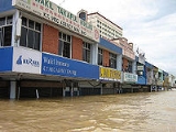
 Urban areas including Batu Pahat
, Johor Bahru
, Kluang
, Kota Tinggi
, Mersing
, Muar
, Pontian
and Segamat
have been flooded. Towns of Kota Tinggi and Segamat were completely cut off. Between 60,000 and 70,000 had been evacuated in Johor itself while food shortage at relief centers had been reported. Until now, schools are still flooded. The government of Malaysia plans to donate uniforms to the victims. Most of the flood victims had been without clean water or electricity for days. According to health authorities, reports of water-borne diseases were on the rise. In some areas, looting was reported after floodwaters receded.
The second wave of the flood, which was larger than the first wave, had almost paralyzed Johor after all 8 districts were submerged by the flood. The worst-affected areas caused by the second flood were Batu Pahat
and Kluang
. Both waves of the flood disaster were considered as the costliest flood in Malaysian history, with the total cost of RM 1.5 billion.
-Mersing
(Federal route 50
) collapsed after being washed by strong current about 4.00 am Saturday.
, 3,193 people from 691 families from Melaka Tengah, Alor Gajah
and Jasin
left their homes due to rising waters.
A total of 35 relief centres were opened , with the floods regarded the worst for the three districts in 15 years.
, more than 2,000 people were evacuated in several areas in Rompin
, especially in Bandar Tun Abdul Razak
. After more than 10 hours of continuous rain, people in Kampung Rekoh in Bandar Tun Abdul Razak were evacuated to nearby community halls. Other affected areas were Kampung Kurnia, Yayasan Estate and Yayasan Estate II. More than 6,000 residents, including settlers in nine Felda Selancar schemes, were also stranded because of two badly damaged bridges in the area.
, the various government departments in charge of flood relief in the state are fully prepared and on standby, said Menteri Besar Datuk Seri Mohamad Hasan.
Flooded areas include Gemas
and Gemencheh
and a total of 80 people have been evacuated so far.
Flood
A flood is an overflow of an expanse of water that submerges land. The EU Floods directive defines a flood as a temporary covering by water of land not normally covered by water...
s that hit Malaysia during December 18, 2006 to January 13, 2007. The floods were caused by above average rainfall, which was attributed to Typhoon Utor which had hit the Philippines
Philippines
The Philippines , officially known as the Republic of the Philippines , is a country in Southeast Asia in the western Pacific Ocean. To its north across the Luzon Strait lies Taiwan. West across the South China Sea sits Vietnam...
and Vietnam
Vietnam
Vietnam – sometimes spelled Viet Nam , officially the Socialist Republic of Vietnam – is the easternmost country on the Indochina Peninsula in Southeast Asia. It is bordered by China to the north, Laos to the northwest, Cambodia to the southwest, and the South China Sea –...
a few days earlier. By the third week of January 2007, Johor was hit by a larger flood. Singapore
Singapore
Singapore , officially the Republic of Singapore, is a Southeast Asian city-state off the southern tip of the Malay Peninsula, north of the equator. An island country made up of 63 islands, it is separated from Malaysia by the Straits of Johor to its north and from Indonesia's Riau Islands by the...
and certain parts of Indonesia
Indonesia
Indonesia , officially the Republic of Indonesia , is a country in Southeast Asia and Oceania. Indonesia is an archipelago comprising approximately 13,000 islands. It has 33 provinces with over 238 million people, and is the world's fourth most populous country. Indonesia is a republic, with an...
were flooded due to the same typhoon.
Throughout the week of December 18, 2006. a series of flood
Flood
A flood is an overflow of an expanse of water that submerges land. The EU Floods directive defines a flood as a temporary covering by water of land not normally covered by water...
s hit Johor
Johor
Johor is a Malaysian state, located in the southern portion of Peninsular Malaysia. It is one of the most developed states in Malaysia. The state capital city and royal city of Johor is Johor Bahru, formerly known as Tanjung Puteri...
, Malacca
Malacca
Malacca , dubbed The Historic State or Negeri Bersejarah among locals) is the third smallest Malaysian state, after Perlis and Penang. It is located in the southern region of the Malay Peninsula, on the Straits of Malacca. It borders Negeri Sembilan to the north and the state of Johor to the south...
, Pahang
Pahang
Pahang is the third largest state in Malaysia, after Sarawak and Sabah, occupying the huge Pahang River river basin. It is bordered to the north by Kelantan, to the west by Perak, Selangor, Negeri Sembilan, to the south by Johor and to the east by Terengganu and the South China Sea.Its state...
and Negeri Sembilan
Negeri Sembilan
Negeri Sembilan, one of the 13 states that constitutes Malaysia, lies on the western coast of Peninsular Malaysia, just south of Kuala Lumpur and borders Selangor on the north, Pahang in the east, and Malacca and Johor to the south....
. During this period, these southern Malaysian states, along with Singapore
Singapore
Singapore , officially the Republic of Singapore, is a Southeast Asian city-state off the southern tip of the Malay Peninsula, north of the equator. An island country made up of 63 islands, it is separated from Malaysia by the Straits of Johor to its north and from Indonesia's Riau Islands by the...
, experienced abnormal rainfall which resulted in massive floods. The rainfall recorded in the city of Johor Bahru
Johor Bahru
Johor Bahru is the capital city of Johor in southern Malaysia. Johor Bahru is the southernmost city of the Eurasian mainland...
on December 19 amounts to 289mm when the annual rainfall of the city alone is 2400mm. In Singapore the 24-hour rainfall recorded on December 20 was 366 mm, the third highest recorded rainfall in 75 years.
The flooding began when torrential downpours since Sunday caused rivers and dams to overflow. Weather officials described the flooding as the worst in the area in a century. At least six people died.
Later that week, beginning December 22, North Sumatra
North Sumatra
North Sumatra is a province of Indonesia on the Sumatra island. Its capital is Medan. It is the most populous Indonesian province outside of Java. It is slightly larger than Sri Lanka in area.- Geography and population :...
and Aceh
Aceh
Aceh is a special region of Indonesia, located on the northern tip of the island of Sumatra. Its full name is Daerah Istimewa Aceh , Nanggroë Aceh Darussalam and Aceh . Past spellings of its name include Acheh, Atjeh and Achin...
experienced abnormal rainfall which also caused flooding An estimated 400,000 people were displaced at the peak of the flooding and at least 118 people dead with 155 people missing as of December 29, 2006. There are fears flash flooding could occur in Malaysia.
Typhoon Utor
Typhoon Utor was blamed for heavy rains of up to 350 mm within 24 hours in southern Peninsular MalaysiaPeninsular Malaysia
Peninsular Malaysia , also known as West Malaysia , is the part of Malaysia which lies on the Malay Peninsula. Its area is . It shares a land border with Thailand in the north. To the south is the island of Singapore. Across the Strait of Malacca to the west lies the island of Sumatra...
, specifically Johor
Johor
Johor is a Malaysian state, located in the southern portion of Peninsular Malaysia. It is one of the most developed states in Malaysia. The state capital city and royal city of Johor is Johor Bahru, formerly known as Tanjung Puteri...
, Negeri Sembilan
Negeri Sembilan
Negeri Sembilan, one of the 13 states that constitutes Malaysia, lies on the western coast of Peninsular Malaysia, just south of Kuala Lumpur and borders Selangor on the north, Pahang in the east, and Malacca and Johor to the south....
, Melaka and Pahang
Pahang
Pahang is the third largest state in Malaysia, after Sarawak and Sabah, occupying the huge Pahang River river basin. It is bordered to the north by Kelantan, to the west by Perak, Selangor, Negeri Sembilan, to the south by Johor and to the east by Terengganu and the South China Sea.Its state...
, causing massive floods within the southern region on December 18, 2006, which was considered as the worst in the Malaysian southern region history. However, there were also reports a few days earlier that adverse weather was not to be blamed on the typhoon. The worst-affected areas were Segamat
Segamat
Segamat is a town and district located in the north of the state of Johor in Malaysia, bordering two other states of Malaysia . It is located roughly 172 kilometres from Johor Bahru, the capital city of Johor State. It is 95 km travel distance via North-South Expressway from Johor Bahru to...
and Kota Tinggi
Kota Tinggi
Kota Tinggi is a town in the state of Johor of Malaysia, located around 42 kilometers north-east of Johor Bahru, on the road to Mersing. Hometown of Azizul Hanipah. Kota Tinggi can also be reached by ferry from Changi terminal in Singapore where tourists need to pass through the immigration check...
, where both towns were totally inaccessible by land after all main roads leading to those towns were flooded. Until January 4, 2007, the floods had claimed 15 lives. Heavy rains are excepted in Penang
Penang
Penang is a state in Malaysia and the name of its constituent island, located on the northwest coast of Peninsular Malaysia by the Strait of Malacca. It is bordered by Kedah in the north and east, and Perak in the south. Penang is the second smallest Malaysian state in area after Perlis, and the...
, Perak
Perak
Perak , one of the 13 states of Malaysia, is the second largest state in the Peninsular Malaysia bordering Kedah and Yala Province of Thailand to the north, Penang to the northwest, Kelantan and Pahang to the east, Selangor the Strait of Malacca to the south and west.Perak means silver in Malay...
, Kelantan
Kelantan
Kelantan is a state of Malaysia. The capital and royal seat is Kota Bharu. The Arabic honorific of the state is Darul Naim, ....
and other states in the northern region at this period.
Situation in Johor
Batu Pahat
Batu Pahat is a district in the state of Johor, Malaysia. It lies south-east of Muar, south-west of Kluang, north-west of Pontian, and south of Segamat and the new Ledang district. The capital of the district is Bandar Penggaram, Batu Pahat....
, Johor Bahru
Johor Bahru
Johor Bahru is the capital city of Johor in southern Malaysia. Johor Bahru is the southernmost city of the Eurasian mainland...
, Kluang
Kluang
Kluang is a town and district located roughly in the middle of the state of Johor in Malaysia. Kluang lies about 110 km north of Johor Bahru, east-southeast of Batu Pahat, west of Mersing and south of Segamat...
, Kota Tinggi
Kota Tinggi
Kota Tinggi is a town in the state of Johor of Malaysia, located around 42 kilometers north-east of Johor Bahru, on the road to Mersing. Hometown of Azizul Hanipah. Kota Tinggi can also be reached by ferry from Changi terminal in Singapore where tourists need to pass through the immigration check...
, Mersing
Mersing
Mersing is a town in Mersing District in the northeast corner of the state of Johor, Malaysia.Mersing town is a lively tourist town visited by Malaysians and foreign tourists....
, Muar
Muar (town)
Muar, also known as Bandar Maharani is a town geopolitically situated in Muar District in the region or area of Muar in northwestern Johor, Malaysia...
, Pontian
Pontian, Johor
Pontian is a district in southwest Johor. It is located 62km from Johor Bahru, the state capital of Johor. It is also located at Miles 37 from Johor Bahru. The name Pontian is also used in the names of two towns in the district, Pontian Besar and Pontian Kechil, of which the latter serves as its...
and Segamat
Segamat
Segamat is a town and district located in the north of the state of Johor in Malaysia, bordering two other states of Malaysia . It is located roughly 172 kilometres from Johor Bahru, the capital city of Johor State. It is 95 km travel distance via North-South Expressway from Johor Bahru to...
have been flooded. Towns of Kota Tinggi and Segamat were completely cut off. Between 60,000 and 70,000 had been evacuated in Johor itself while food shortage at relief centers had been reported. Until now, schools are still flooded. The government of Malaysia plans to donate uniforms to the victims. Most of the flood victims had been without clean water or electricity for days. According to health authorities, reports of water-borne diseases were on the rise. In some areas, looting was reported after floodwaters receded.
The second wave of the flood, which was larger than the first wave, had almost paralyzed Johor after all 8 districts were submerged by the flood. The worst-affected areas caused by the second flood were Batu Pahat
Batu Pahat
Batu Pahat is a district in the state of Johor, Malaysia. It lies south-east of Muar, south-west of Kluang, north-west of Pontian, and south of Segamat and the new Ledang district. The capital of the district is Bandar Penggaram, Batu Pahat....
and Kluang
Kluang
Kluang is a town and district located roughly in the middle of the state of Johor in Malaysia. Kluang lies about 110 km north of Johor Bahru, east-southeast of Batu Pahat, west of Mersing and south of Segamat...
. Both waves of the flood disaster were considered as the costliest flood in Malaysian history, with the total cost of RM 1.5 billion.
Kota Tinggi
On 12 January 2007 Friday early morning the flood water was slowly increasing at Jalan Jaffar, while the residents were all shifting their goods for preparing the second flood.Kluang
On Saturday morning 13 January 2007, The Sungai Semberong bridge at Batu 5, Jalan KluangKluang
Kluang is a town and district located roughly in the middle of the state of Johor in Malaysia. Kluang lies about 110 km north of Johor Bahru, east-southeast of Batu Pahat, west of Mersing and south of Segamat...
-Mersing
Mersing
Mersing is a town in Mersing District in the northeast corner of the state of Johor, Malaysia.Mersing town is a lively tourist town visited by Malaysians and foreign tourists....
(Federal route 50
Malaysia Federal Route 50
Federal Route 50 is a federal road in Johor, Malaysia. The roads connects Batu Pahat in the west to Jemaluang in the east.-Route background:...
) collapsed after being washed by strong current about 4.00 am Saturday.
Situation in Malacca
In MalaccaMalacca
Malacca , dubbed The Historic State or Negeri Bersejarah among locals) is the third smallest Malaysian state, after Perlis and Penang. It is located in the southern region of the Malay Peninsula, on the Straits of Malacca. It borders Negeri Sembilan to the north and the state of Johor to the south...
, 3,193 people from 691 families from Melaka Tengah, Alor Gajah
Alor Gajah
Alur Gajah is a town and district in Malacca, Malaysia. Alor Gajah is also a parliamentary constituency of Melaka. It borders Tampin, Negeri Sembilan to the north. This town has a railway station at Pulau Subang about 10 kilometres from the town area...
and Jasin
Jasin
Jasin District is one of the three districts in the State of Malacca, Malaysia. The other two are the Central Malacca district and the Alor Gajah district. Jasin District is the southernmost of the three districts, and borders the State of Johor. Jasin is also the name of the main town in the...
left their homes due to rising waters.
A total of 35 relief centres were opened , with the floods regarded the worst for the three districts in 15 years.
Situation in Pahang
In PahangPahang
Pahang is the third largest state in Malaysia, after Sarawak and Sabah, occupying the huge Pahang River river basin. It is bordered to the north by Kelantan, to the west by Perak, Selangor, Negeri Sembilan, to the south by Johor and to the east by Terengganu and the South China Sea.Its state...
, more than 2,000 people were evacuated in several areas in Rompin
Rompin
Rompin is a small fishing village and township on the southern end of Pahang, Malaysia. It is located within the district of Rompin. The Rompin River flows through the town. The Endau Rompin National Park is partly situated within the Rompin district....
, especially in Bandar Tun Abdul Razak
Bandar Tun Abdul Razak
Bandar Tun Abdul Razak is a small town located in the west Rompin in Pahang, Malaysia. This town located 27 kilometres from Bandar Muadzam Shah and 127 kilometres from Kuantan, the capital city of Pahang State. The town is strategically situated between Johor Bahru and Kuantan, where the Tun Razak...
. After more than 10 hours of continuous rain, people in Kampung Rekoh in Bandar Tun Abdul Razak were evacuated to nearby community halls. Other affected areas were Kampung Kurnia, Yayasan Estate and Yayasan Estate II. More than 6,000 residents, including settlers in nine Felda Selancar schemes, were also stranded because of two badly damaged bridges in the area.
Situation in Negeri Sembilan
In Negeri SembilanNegeri Sembilan
Negeri Sembilan, one of the 13 states that constitutes Malaysia, lies on the western coast of Peninsular Malaysia, just south of Kuala Lumpur and borders Selangor on the north, Pahang in the east, and Malacca and Johor to the south....
, the various government departments in charge of flood relief in the state are fully prepared and on standby, said Menteri Besar Datuk Seri Mohamad Hasan.
Flooded areas include Gemas
Gemas
Gemas is a small town in Negeri Sembilan, Malaysia, just near the Negeri Sembilan-Johor state border. The town is located approximately 165 km from the Malaysian capital Kuala Lumpur. It is the meeting place of Malaysian west and east coast rail lines operated by Malayan Railways. For this...
and Gemencheh
Gemencheh
- Gemencheh Bridge during Battle of Malaya :During the Battle of Malaya in the Second World War, Gemencheh Bridge near Gemas was the site of a fierce battle between the Imperial Japanese Army and the 2/30 Battalion, 8 Division, Australian Imperial Force . Commanding Officer of the Battalion was...
and a total of 80 people have been evacuated so far.