

Advanced Spaceborne Thermal Emission and Reflection Radiometer
Encyclopedia
Remote sensing
Remote sensing is the acquisition of information about an object or phenomenon, without making physical contact with the object. In modern usage, the term generally refers to the use of aerial sensor technologies to detect and classify objects on Earth by means of propagated signals Remote sensing...
on board the Terra
Terra (satellite)
Terra is a multi-national NASA scientific research satellite in a sun-synchronous orbit around the Earth. It is the flagship of the Earth Observing System...
satellite launched into Earth orbit by NASA
NASA
The National Aeronautics and Space Administration is the agency of the United States government that is responsible for the nation's civilian space program and for aeronautics and aerospace research...
in 1999. The instrument has been collecting superficial data since February 2000.
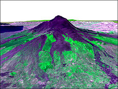
ASTER provides high-resolution images of the planet Earth
Earth
Earth is the third planet from the Sun, and the densest and fifth-largest of the eight planets in the Solar System. It is also the largest of the Solar System's four terrestrial planets...
in 15 different band
Spectral bands
Spectral bands are part of optical spectra of polyatomic systems, including condensed materials, large molecules etc. Each line corresponding to one level in atom splits in molecules. When the number of atoms is large, one gets continuum of energy levels, so called "spectral bands". They are often...
s of the electromagnetic spectrum
Electromagnetic spectrum
The electromagnetic spectrum is the range of all possible frequencies of electromagnetic radiation. The "electromagnetic spectrum" of an object is the characteristic distribution of electromagnetic radiation emitted or absorbed by that particular object....
, ranging from visible to thermal infrared
Infrared
Infrared light is electromagnetic radiation with a wavelength longer than that of visible light, measured from the nominal edge of visible red light at 0.74 micrometres , and extending conventionally to 300 µm...
light. The resolution
Angular resolution
Angular resolution, or spatial resolution, describes the ability of any image-forming device such as an optical or radio telescope, a microscope, a camera, or an eye, to distinguish small details of an object...
of images ranges between 15 to 90 meters. ASTER data are used to create detailed maps of surface temperature
Temperature
Temperature is a physical property of matter that quantitatively expresses the common notions of hot and cold. Objects of low temperature are cold, while various degrees of higher temperatures are referred to as warm or hot...
of land, emissivity
Emissivity
The emissivity of a material is the relative ability of its surface to emit energy by radiation. It is the ratio of energy radiated by a particular material to energy radiated by a black body at the same temperature...
, reflectance, and elevation
Elevation
The elevation of a geographic location is its height above a fixed reference point, most commonly a reference geoid, a mathematical model of the Earth's sea level as an equipotential gravitational surface ....
.
ASTER Bands
| Band | Label | Wavelength Electromagnetic radiation Electromagnetic radiation is a form of energy that exhibits wave-like behavior as it travels through space... (µm Micrometre A micrometer , is by definition 1×10⁻⁶ of a meter .In plain English, it means one-millionth of a meter . Its unit symbol in the International System of Units is μm... ) |
Resolution Image resolution Image resolution is an umbrella term that describes the detail an image holds. The term applies to raster digital images, film images, and other types of images. Higher resolution means more image detail.... (m) |
Nadir Nadir The nadir is the direction pointing directly below a particular location; that is, it is one of two vertical directions at a specified location, orthogonal to a horizontal flat surface there. Since the concept of being below is itself somewhat vague, scientists define the nadir in more rigorous... or Backward |
Description |
|---|---|---|---|---|---|
| B1 | VNIR VNIR VNIR is an initialism for visible and near-infrared, a portion of the electromagnetic spectrum having wavelengths between approximately 400 and 1400 nanometers ... _Band1 |
0.520–0.600 | 15 | Nadir | Visible green/yellow |
| B2 | VNIR_Band2 | 0.630–0.690 | 15 | Nadir | Visible red |
| B3 | VNIR_Band3N | 0.760–0.860 | 15 | Nadir | Near infrared |
| B4 | VNIR_Band3B | 0.760–0.860 | 15 | Backward | |
| B5 | SWIR_Band4 | 1.600–1.700 | 30 | Nadir | Short-wave infrared |
| B6 | SWIR_Band5 | 2.145–2.185 | 30 | Nadir | |
| B7 | SWIR_Band6 | 2.185–2.225 | 30 | Nadir | |
| B8 | SWIR_Band7 | 2.235–2.285 | 30 | Nadir | |
| B9 | SWIR_Band8 | 2.295–2.365 | 30 | Nadir | |
| B10 | SWIR_Band9 | 2.360–2.430 | 30 | Nadir | |
| B11 | TIR_Band10 | 8.125–8.475 | 90 | Nadir | Long-wave infrared or thermal IR |
| B12 | TIR_Band11 | 8.475–8.825 | 90 | Nadir | |
| B13 | TIR_Band12 | 8.925–9.275 | 90 | Nadir | |
| B14 | TIR_Band13 | 10.250–10.950 | 90 | Nadir | |
| B15 | TIR_Band14 | 10.950–11.650 | 90 | Nadir | |
Version 1
On 29 June 2009, the Global Digital Elevation Model (GDEM) was released to the public.A joint operation between NASA
NASA
The National Aeronautics and Space Administration is the agency of the United States government that is responsible for the nation's civilian space program and for aeronautics and aerospace research...
and Japan's Ministry of Economy, Trade and Industry (METI), the Global Digital Elevation Model is the most complete mapping of the earth ever made, covering 99% of its surface.
The previous most comprehensive map, NASA's Shuttle Radar Topography Mission
Shuttle Radar Topography Mission
The Shuttle Radar Topography Mission is an international research effort that obtained digital elevation models on a near-global scale from 56° S to 60° N, to generate the most complete high-resolution digital topographic database of Earth prior to the release of the ASTER GDEM in 2009...
, covered approximately 80% of the Earth's surface, with a global resolution of 90 meters, and a resolution of 30 meters over the USA.
The GDEM covers the planet from 83 degrees North to 83 degrees South (surpassing SRTM's coverage of 56 °S to 60 °N), becoming the first earth mapping system that provides comprehensive coverage of the polar regions. It was created by compiling 1.3 million VNIR
VNIR
VNIR is an initialism for visible and near-infrared, a portion of the electromagnetic spectrum having wavelengths between approximately 400 and 1400 nanometers ...
images taken by ASTER using single-pass stereoscopic correlation
Digital image correlation
Digital Image Correlation and Tracking is an optical method that employs tracking & image registration techniques for accurate 2D and 3D measurements of changes in images. This is often used to measure deformation , displacement, and strain, but it is widely applied in many areas of science and...
techniques, with terrain elevation measurements taken globally at 30 meter (98 ft) intervals.
Despite the high nominal resolution, however, some reviewers have commented that the true resolution is considerably lower, and not as good as that of SRTM data, and serious artifacts are present. Some of these limitations have been confirmed by METI and NASA, who point out that the current version of the GDEM product is "research grade".
Version 2
During October 2011 version 2 of Global Digital Elevation Model was publically released.See also
- Shuttle Radar Topography Mission (SRTM)Shuttle Radar Topography MissionThe Shuttle Radar Topography Mission is an international research effort that obtained digital elevation models on a near-global scale from 56° S to 60° N, to generate the most complete high-resolution digital topographic database of Earth prior to the release of the ASTER GDEM in 2009...
- Ground Sampling DistanceGround Sampling DistanceGround Sampling Distance is the physical measure of the level of detail of data collection for remote digital imaging of the surfaces of terrestrial objects of the Solar System, including the Earth....
- TerraLook