

Akoni Pule Highway
Encyclopedia
The Akoni Pule Highway, Hawaii State Highway Route 270, is the main road along the North Kohala
Coast on the Island of Hawaii
from Kawaihae
to Upolu Point
and then on to Pololū Valley
Lookout.
was along the winding, narrow Kohala Mountain Road
(then Route 25, now 250). The Hawaii Department of Transportation
already had plans for a coastal Route 11 along the Kohala Peninsula
in the early-1960s to connect with Routes 25 and 27 in Hāwī. However, about the only action taken over the next ten years was the reässignment of highway shield
numbers and assigning number 270 to the proposed highway.
Akoni Pule (1906–1971), the State legislator
who represented North Kohala from 1947 to 1965, pushed for a safer alternative to Kohala Mountain Road and a second access to the towns of Hāwī and Kapaau. He was also instrumental in providing the necessary state and federal funds
to complete construction. The new road was dedicated in his honor in July 1973.
. The first green mile marker
on Kawaihae Road is mile 2 just past the “Queen K,” with the first two miles (3.2 km) being absorbed into Route 19 when it was reäligned in 1975.
Further south is Samuel M. Spencer Beach Park, a popular spot with a large sandy beach, shaded grassy areas, and picnic tables. Adjacent to the park is Puukoholā Heiau National Historic Site
, a temple
built by Kamehameha I
in 1790–91 and dedicated to the war god Kū
. Kū was pleased, and allowed Kamehameha I to wage several subsequent battles using Western military strategy
and weapon
s to extend his control over all Hawaiian Islands
. Also at this site are the smaller Mailekini Heiau, the submerged Hale o Kapuni Heiau, and home site of John Young
.
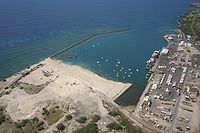
Passing mile 3, the next feature is the harbor of Kawaihae
, built in 1959 as a fuel depot, shipping terminal and military landing site. The small town surrounding the port features a number of restaurants, shops and art galleries, as well as a popular surfing
and canoeing
spot.
 Route 270 branches right onto Akoni Pule Highway at the T junction fronting the harbor (Kawaihae Road continues straight on the former Route 269 spur for another 1,000 ft/305 m).
.
The terrain is dry and rocky since this area is in the rain shadow
of Mauna Kea
and the Kohala Mountains
. Average annual rainfall
is from four-to-seven inches (10–18 cm) and wildfire
s are not uncommon here. The cobalt color of the Pacific Ocean provides a backdrop for the gated communities of Kohala Ranch and Kohala Waterfront.
Akoni Pule Highway crosses into North Kohala District
near mile 6 and continues along the rocky coastline with only an occasional dirt road
leading mauka (uphill) into rangeland
s or makai providing access to favored fishing spots. Just before the mile 14 marker is the entrance to Lapakahi State Historical Park
, site of an ancient fishing village that illustrates the traditional land divisions known as ahupuaa.
The next point-of-interest is Māhukona Park
, an abandoned harbor
once used by the adjacent Kohala Sugar Mill. This was also the terminus for the Hawaiian Railroad, a 20 miles (32.2 km) long, three-foot (91 cm) gauge track that brought sugarcane
from plantation
s to waiting steamships
. The waters are clear and perfect for snorkeling
around discarded mill equipment and even a shipwreck.
As Akoni Pule Highway begins a long, sweeping right curve near mile 15, it moves away from the coast and the landscape takes on a different character: the grass is greener, the trees become more abundant, and the air is cooler as the trade wind
s are able to bring more precipitation to this area.
It is highly recommended that drivers strictly adhere to the speed limit
signs in North Kohala. With a low crime rate the police have more time to attend to traffic violations.
Across from the mile 20 marker is Upolu Point (Airport) Road which leads to Upolu Airport
and provides access (via a rough unpaved Four-wheel drive
road) to Mookini Heiau and the birthplace of Kamehameha I
in the Kohala Historical Sites State Monument.
The small town of Hāwī centers on the crossroads of Hāwī Road
(Route 250) and Akoni Pule Highway just beyond mile 21. This area was home to thousands of people in the early 20th Century. No less than 56 general store
s, owned and operated by first-generation Asian immigrants, were established in the vicinity and a handful of these businesses still are in operation.
The entire highway to this point is used for the bicycle leg of the Ironman World Championship
Triathlon.
At this junction the athletes turn around and return to the finish line at Kamakahonu
in Kailua-Kona.
Since there are no public roads past Kynnersley Road that connect to the rest of Hawaii Island
, Route 270 becomes, in a sense, a 6½ mile (10.5kM) long cul-de-sac
. A short drive further down Akoni Pule Highway is Kapaau. Many public services are based here, including police and fire stations, a hospital, schools and a civic center. In front of the latter stands the original Statue of King Kamehameha the Great
that was once lost in a shipwreck off South America in 1880 but then recovered and sent to Kapaau 32 years later.
The road resembles a country
lane more than a highway as it passes the former plantation camps that dot the North Kohala Coast. There are three one-lane bridges: two cross gulch
es midway through the horseshoe curve
s and the other at mile 26. Caution needs to be observed and obey the yield sign
s. A county park with a picnic pavilion and a gazebo
overlooks Kēōkea Bay at the end of Kēōkea Beach Road.
At mile 28.9, the Akoni Pule Highway comes to an abrupt end at the Pololū Valley
Scenic Point, 20°12′13"N 155°44′1"W. It is a tight turnaround on a downhill slope
with a lot of foot traffic so caution is advised. There is a small parking area here but respect the kapu
signs on the adjacent private properties. The trailhead
to Pololū is at the end of the asphalt.
Kohala, Hawaii
thumb|right|300px|The districts of the [[Hawaii |Big Island]]. From Northernmost, clockwise; Kohala , [[Hamakua|Hāmākua]], [[Hilo, Hawaii|Hilo]], [[Puna, Hawaii|Puna]], [[Kau, Hawaii|Kaū]], [[Kona District, Hawaii|Kona]]...
Coast on the Island of Hawaii
Hawaii (island)
The Island of Hawaii, also called the Big Island or Hawaii Island , is a volcanic island in the North Pacific Ocean...
from Kawaihae
Kawaihae
Kawaihae is an unincorporated community on the west side of the island of Hawaii in the U.S. state of Hawaii, north of Kailua-Kona. Its harbor includes a fuel depot, shipping terminal and military landing site. Outside of the man-made breakwall of the harbor is a popular surf spot and the Pua...
to Upolu Point
Upolu Point
Upolu Point is the most northern point on the island of Hawaii in the Hawaiian Islands. It is an extruding landform created by cooled lava from an old eruption from Kohala volcano. The main town on the extrusion is Hawi, Hawaii about 2 miles inland...
and then on to Pololū Valley
Pololu Valley
Pololū is the Northernmost of a series of erosional valleys forming the east coast of Kohala Mountain on the Island of Hawaii. The word Pololū means long spear in the Hawaiian language.- Features :...
Lookout.
- Total miles = 27.0 (43.5 km)
History
Prior to the 1970s, the only means of driving to North Kohala DistrictKohala, Hawaii
thumb|right|300px|The districts of the [[Hawaii |Big Island]]. From Northernmost, clockwise; Kohala , [[Hamakua|Hāmākua]], [[Hilo, Hawaii|Hilo]], [[Puna, Hawaii|Puna]], [[Kau, Hawaii|Kaū]], [[Kona District, Hawaii|Kona]]...
was along the winding, narrow Kohala Mountain Road
Kohala Mountain Road
Kohala Mountain Road, designated Route 250, travels upon the Kohala mountain on the island of Hawaii in the state of Hawaii, United States.Kohala Mountain road begins about west of Waimea, at , near the Hawaii Preparatory Academy campus...
(then Route 25, now 250). The Hawaii Department of Transportation
Hawaii Department of Transportation
The Hawaii Department of Transportation is a state government organization which oversees transportation in the U.S. state of Hawaii. The agency is divided into three divisions dealing with aviation, maritime, and roads.-Airports Division:...
already had plans for a coastal Route 11 along the Kohala Peninsula
Peninsula
A peninsula is a piece of land that is bordered by water on three sides but connected to mainland. In many Germanic and Celtic languages and also in Baltic, Slavic and Hungarian, peninsulas are called "half-islands"....
in the early-1960s to connect with Routes 25 and 27 in Hāwī. However, about the only action taken over the next ten years was the reässignment of highway shield
Highway shield
A highway shield is a sign denoting the route number of a highway, usually in the form of a symbolic shape with the route number enclosed. As the focus of the sign, the route number is usually the sign's largest element, with other items on the sign rendered in smaller sizes or contrasting colours...
numbers and assigning number 270 to the proposed highway.
Akoni Pule (1906–1971), the State legislator
Hawaii Legislature
The Hawaii State Legislature is the state legislature of the U.S. state of Hawaii. The state legislature is a bicameral body consisting of a lower house, the Hawaii House of Representatives with 51 representatives, and an upper house, the 25-member Hawaii Senate. There are a total of 76...
who represented North Kohala from 1947 to 1965, pushed for a safer alternative to Kohala Mountain Road and a second access to the towns of Hāwī and Kapaau. He was also instrumental in providing the necessary state and federal funds
Federal funds
In the United States, federal funds are overnight borrowings by banks to maintain their bank reserves at the Federal Reserve. Banks keep reserves at Federal Reserve Banks to meet their reserve requirements and to clear financial transactions...
to complete construction. The new road was dedicated in his honor in July 1973.
Kawaihae Road
Although Kawaihae Road begins in the town of Waimea as part of the Hawaii Belt Road, Route 270 starts at the T junction near mile 67, where Route 19 becomes known as Queen Kaahumanu HighwayKa'ahumanu
Elizabeth Kaahumanu was queen regent of the Kingdom of Hawaii and a wife of Kamehameha I. She was the king's favorite wife and also the most politically powerful, and continued to wield considerable power in the kingdom as the kuhina nui during the reigns of his first two successors.-Early...
. The first green mile marker
Milestone
A milestone is one of a series of numbered markers placed along a road or boundary at intervals of one mile or occasionally, parts of a mile. They are typically located at the side of the road or in a median. They are alternatively known as mile markers, mileposts or mile posts...
on Kawaihae Road is mile 2 just past the “Queen K,” with the first two miles (3.2 km) being absorbed into Route 19 when it was reäligned in 1975.
Further south is Samuel M. Spencer Beach Park, a popular spot with a large sandy beach, shaded grassy areas, and picnic tables. Adjacent to the park is Puukoholā Heiau National Historic Site
Puukohola Heiau National Historic Site
Puukoholā Heiau National Historic Site is a United States National Historic Site located on the northwestern coast of the island of Hawaii. The site preserves the National Historic Landmark ruins of the last major Ancient Hawaiian temple, and other historic sites.-The time of unification:Kamehameha...
, a temple
Heiau
A heiau is a Hawaiian temple. Many types of heiau existed, including heiau to treat the sick , offer first fruits, offer first catch, start rain, stop rain, increase the population, ensure health of the nation, achieve success in distant voyaging, reach peace, and achieve success in war . Only the...
built by Kamehameha I
Kamehameha I
Kamehameha I , also known as Kamehameha the Great, conquered the Hawaiian Islands and formally established the Kingdom of Hawaii in 1810. By developing alliances with the major Pacific colonial powers, Kamehameha preserved Hawaii's independence under his rule...
in 1790–91 and dedicated to the war god Kū
Kū
In Hawaiian mythology Kū or Kū-ka-ili-moku is one of the four great gods along with Kanaloa, Kāne, and Lono.He is known as the god of war and the husband of the goddess Hina. Some have taken this to suggest a complementary dualism, as the word kū in the Hawaiian language means "standing up" while...
. Kū was pleased, and allowed Kamehameha I to wage several subsequent battles using Western military strategy
Military strategy
Military strategy is a set of ideas implemented by military organizations to pursue desired strategic goals. Derived from the Greek strategos, strategy when it appeared in use during the 18th century, was seen in its narrow sense as the "art of the general", 'the art of arrangement' of troops...
and weapon
Weapon
A weapon, arm, or armament is a tool or instrument used with the aim of causing damage or harm to living beings or artificial structures or systems...
s to extend his control over all Hawaiian Islands
Hawaiian Islands
The Hawaiian Islands are an archipelago of eight major islands, several atolls, numerous smaller islets, and undersea seamounts in the North Pacific Ocean, extending some 1,500 miles from the island of Hawaii in the south to northernmost Kure Atoll...
. Also at this site are the smaller Mailekini Heiau, the submerged Hale o Kapuni Heiau, and home site of John Young
John Young (Hawaii)
John Young was a British subject who became an important military advisor to Kamehameha I during the formation of the Kingdom of Hawaii. He was left behind by Simon Metcalfe, captain of the American ship Eleanora, and along with a Welshmen Isaac Davis became a friend and advisor to Kamehameha...
.
Passing mile 3, the next feature is the harbor of Kawaihae
Kawaihae
Kawaihae is an unincorporated community on the west side of the island of Hawaii in the U.S. state of Hawaii, north of Kailua-Kona. Its harbor includes a fuel depot, shipping terminal and military landing site. Outside of the man-made breakwall of the harbor is a popular surf spot and the Pua...
, built in 1959 as a fuel depot, shipping terminal and military landing site. The small town surrounding the port features a number of restaurants, shops and art galleries, as well as a popular surfing
Surfing
Surfing' is a surface water sport in which the surfer rides a surfboard on the crest and face of a wave which is carrying the surfer towards the shore...
and canoeing
Canoeing
Canoeing is an outdoor activity that involves a special kind of canoe.Open canoes may be 'poled' , sailed, 'lined and tracked' or even 'gunnel-bobbed'....
spot.
- Total miles = 1.5 (2.4 km)
Akoni Pule Highway
The intersection in Kawaihae marks the beginning of Akoni Pule Highway. It starts as a narrow two-lane street but becomes wider, with higher speeds, past the Kāei Hana II industrial parkIndustrial park
An industrial park is an area zoned and planned for the purpose of industrial development...
.
The terrain is dry and rocky since this area is in the rain shadow
Rain shadow
A rain shadow is a dry area on the lee side of a mountainous area. The mountains block the passage of rain-producing weather systems, casting a "shadow" of dryness behind them. As shown by the diagram to the right, the warm moist air is "pulled" by the prevailing winds over a mountain...
of Mauna Kea
Mauna Kea
Mauna Kea is a volcano on the island of Hawaii. Standing above sea level, its peak is the highest point in the state of Hawaii. However, much of the mountain is under water; when measured from its oceanic base, Mauna Kea is over tall—significantly taller than Mount Everest...
and the Kohala Mountains
Kohala (mountain)
Kohala is the oldest of five volcanoes that make up the island of Hawaii. Kohala is an estimated one million years old—so old that it experienced, and recorded, a reversal of magnetic field 780,000 years ago. It is believed to have breached sea level more than 500,000 years ago and to...
. Average annual rainfall
Precipitation (meteorology)
In meteorology, precipitation In meteorology, precipitation In meteorology, precipitation (also known as one of the classes of hydrometeors, which are atmospheric water phenomena is any product of the condensation of atmospheric water vapor that falls under gravity. The main forms of precipitation...
is from four-to-seven inches (10–18 cm) and wildfire
Wildfire
A wildfire is any uncontrolled fire in combustible vegetation that occurs in the countryside or a wilderness area. Other names such as brush fire, bushfire, forest fire, desert fire, grass fire, hill fire, squirrel fire, vegetation fire, veldfire, and wilkjjofire may be used to describe the same...
s are not uncommon here. The cobalt color of the Pacific Ocean provides a backdrop for the gated communities of Kohala Ranch and Kohala Waterfront.
Akoni Pule Highway crosses into North Kohala District
Kohala, Hawaii
thumb|right|300px|The districts of the [[Hawaii |Big Island]]. From Northernmost, clockwise; Kohala , [[Hamakua|Hāmākua]], [[Hilo, Hawaii|Hilo]], [[Puna, Hawaii|Puna]], [[Kau, Hawaii|Kaū]], [[Kona District, Hawaii|Kona]]...
near mile 6 and continues along the rocky coastline with only an occasional dirt road
Dirt road
Dirt road is a common term for an unpaved road made from the native material of the land surface through which it passes, known to highway engineers as subgrade material. Dirt roads are suitable for vehicles; a narrower path for pedestrians, animals, and possibly small vehicles would be called a...
leading mauka (uphill) into rangeland
Rangeland
Rangelands are vast natural landscapes in the form of grasslands, shrublands, woodlands, wetlands, and deserts. Types of rangelands include tallgrass and shortgrass prairies, desert grasslands and shrublands, woodlands, savannas, chaparrals, steppes, and tundras...
s or makai providing access to favored fishing spots. Just before the mile 14 marker is the entrance to Lapakahi State Historical Park
Lapakahi State Historical Park
Lapakahi State Historical Park is a large area of ruins from an Ancient Hawaiian fishing village in the North Kohala District on the Big Island of Hawaii.Off shore is the Lapakahi Marine Life Conservation District....
, site of an ancient fishing village that illustrates the traditional land divisions known as ahupuaa.
The next point-of-interest is Māhukona Park
Mahukona, Hawaii
Māhukona is a former settlement on the island of Hawaii. The extinct submerged volcano Māhukona, off shore and to the south, is named for this area. It was once the terminus of the Hawaiian Railroad.-History:...
, an abandoned harbor
Harbor
A harbor or harbour , or haven, is a place where ships, boats, and barges can seek shelter from stormy weather, or else are stored for future use. Harbors can be natural or artificial...
once used by the adjacent Kohala Sugar Mill. This was also the terminus for the Hawaiian Railroad, a 20 miles (32.2 km) long, three-foot (91 cm) gauge track that brought sugarcane
Sugarcane
Sugarcane refers to any of six to 37 species of tall perennial grasses of the genus Saccharum . Native to the warm temperate to tropical regions of South Asia, they have stout, jointed, fibrous stalks that are rich in sugar, and measure two to six metres tall...
from plantation
Plantation
A plantation is a long artificially established forest, farm or estate, where crops are grown for sale, often in distant markets rather than for local on-site consumption...
s to waiting steamships
Steamboat
A steamboat or steamship, sometimes called a steamer, is a ship in which the primary method of propulsion is steam power, typically driving propellers or paddlewheels...
. The waters are clear and perfect for snorkeling
Snorkeling
Snorkeling is the practice of swimming on or through a body of water while equipped with a diving mask, a shaped tube called a snorkel, and usually swimfins. In cooler waters, a wetsuit may also be worn...
around discarded mill equipment and even a shipwreck.
As Akoni Pule Highway begins a long, sweeping right curve near mile 15, it moves away from the coast and the landscape takes on a different character: the grass is greener, the trees become more abundant, and the air is cooler as the trade wind
Trade wind
The trade winds are the prevailing pattern of easterly surface winds found in the tropics, within the lower portion of the Earth's atmosphere, in the lower section of the troposphere near the Earth's equator...
s are able to bring more precipitation to this area.
It is highly recommended that drivers strictly adhere to the speed limit
Speed limits in the United States
Speed limits in the United States are set by each state or territory. Speed limits in the United States vary according to many factors, including each state or territory's laws, the type of road, land use, and more. Increments of five miles per hour are used. Additionally, these limits sometimes...
signs in North Kohala. With a low crime rate the police have more time to attend to traffic violations.
Across from the mile 20 marker is Upolu Point (Airport) Road which leads to Upolu Airport
Upolu Airport
Upolu Airport is a regional airport of the State of Hawai'i in Hawai'i County. Located on the northern tip of the Big Island, Upolu Airport is northwest of the unincorporated town of Hawi.- Facilities and aircraft :...
and provides access (via a rough unpaved Four-wheel drive
Four-wheel drive
Four-wheel drive, 4WD, or 4×4 is a four-wheeled vehicle with a drivetrain that allows all four wheels to receive torque from the engine simultaneously...
road) to Mookini Heiau and the birthplace of Kamehameha I
Kamehameha I
Kamehameha I , also known as Kamehameha the Great, conquered the Hawaiian Islands and formally established the Kingdom of Hawaii in 1810. By developing alliances with the major Pacific colonial powers, Kamehameha preserved Hawaii's independence under his rule...
in the Kohala Historical Sites State Monument.
The small town of Hāwī centers on the crossroads of Hāwī Road
Kohala Mountain Road
Kohala Mountain Road, designated Route 250, travels upon the Kohala mountain on the island of Hawaii in the state of Hawaii, United States.Kohala Mountain road begins about west of Waimea, at , near the Hawaii Preparatory Academy campus...
(Route 250) and Akoni Pule Highway just beyond mile 21. This area was home to thousands of people in the early 20th Century. No less than 56 general store
General store
A general store, general merchandise store, or village shop is a rural or small town store that carries a general line of merchandise. It carries a broad selection of merchandise, sometimes in a small space, where people from the town and surrounding rural areas come to purchase all their general...
s, owned and operated by first-generation Asian immigrants, were established in the vicinity and a handful of these businesses still are in operation.
The entire highway to this point is used for the bicycle leg of the Ironman World Championship
Ironman World Championship
The Ironman World Championship has been held annually in Hawaii since 1978, with an additional race in 1982. It is owned and organised by the World Triathlon Corporation and is currently sponsored by Ford...
Triathlon.
At this junction the athletes turn around and return to the finish line at Kamakahonu
Kamakahonu
Kamakahonu, the residence of Kamehameha I, was located at the North end of Kailua Bay in Kailua-Kona on Hawaiʻi Island.-History:Kamehameha I , who unified the Hawaiian Islands, lived out the last years of his life and instituted some of the most constructive measures of his reign here...
in Kailua-Kona.
Since there are no public roads past Kynnersley Road that connect to the rest of Hawaii Island
Hawaii (island)
The Island of Hawaii, also called the Big Island or Hawaii Island , is a volcanic island in the North Pacific Ocean...
, Route 270 becomes, in a sense, a 6½ mile (10.5kM) long cul-de-sac
Cul-de-sac
A cul-de-sac is a word of French origin referring to a dead end, close, no through road or court meaning dead-end street with only one inlet/outlet...
. A short drive further down Akoni Pule Highway is Kapaau. Many public services are based here, including police and fire stations, a hospital, schools and a civic center. In front of the latter stands the original Statue of King Kamehameha the Great
Kamehameha Statue
Several Kamehameha Statues honor the monarch who founded the Kingdom of Hawaii.-Gould's work:One stands prominently in front of Aliiolani Hale in Honolulu, Hawaii. The statue had its origins in 1878 when Walter M. Gibson, a member of the Hawaiian government at the time, wanted to commemorate the...
that was once lost in a shipwreck off South America in 1880 but then recovered and sent to Kapaau 32 years later.
The road resembles a country
Rural
Rural areas or the country or countryside are areas that are not urbanized, though when large areas are described, country towns and smaller cities will be included. They have a low population density, and typically much of the land is devoted to agriculture...
lane more than a highway as it passes the former plantation camps that dot the North Kohala Coast. There are three one-lane bridges: two cross gulch
Gulch
A gulch is a deep V-shaped valley formed by erosion. It may contain a small stream or dry creek bed and is usually larger in size than a gully. Occasionally, sudden intense rainfall may produce flash floods in the area of the gulch....
es midway through the horseshoe curve
Horseshoe curve (railway)
A horseshoe curve is a tight curve in a railway or a road, through an angle in excess of 180 degrees. A horseshoe curve is a means to lengthen the passage of an ascending or descending grade, so as to reduce the maximum gradient of ascent or descent. The horseshoe refers to the U shaped bypass of...
s and the other at mile 26. Caution needs to be observed and obey the yield sign
Yield sign
In road transport, a ' or ' traffic sign indicates that each driver must prepare to stop if necessary to let a driver on another approach proceed. A driver who stops has yielded the right of way to another...
s. A county park with a picnic pavilion and a gazebo
Gazebo
A gazebo is a pavilion structure, sometimes octagonal, that may be built, in parks, gardens, and spacious public areas. Gazebos are freestanding or attached to a garden wall, roofed, and open on all sides; they provide shade, shelter, ornamental features in a landscape, and a place to rest...
overlooks Kēōkea Bay at the end of Kēōkea Beach Road.
At mile 28.9, the Akoni Pule Highway comes to an abrupt end at the Pololū Valley
Pololu Valley
Pololū is the Northernmost of a series of erosional valleys forming the east coast of Kohala Mountain on the Island of Hawaii. The word Pololū means long spear in the Hawaiian language.- Features :...
Scenic Point, 20°12′13"N 155°44′1"W. It is a tight turnaround on a downhill slope
Slope
In mathematics, the slope or gradient of a line describes its steepness, incline, or grade. A higher slope value indicates a steeper incline....
with a lot of foot traffic so caution is advised. There is a small parking area here but respect the kapu
Kapu
Kapu refers to the ancient Hawaiian code of conduct of laws and regulations. The kapu system was universal in lifestyle, gender roles, politics, religion, etc. An offense that was kapu was often a corporal offense, but also often denoted a threat to spiritual power, or theft of mana. Kapus were...
signs on the adjacent private properties. The trailhead
Trailhead
A trailhead is the point at which a trail begins, where the trail is often intended for hiking, biking, horseback riding, or off-road vehicles...
to Pololū is at the end of the asphalt.
- Total miles = 25.5 (41.1 km)
Junctions
County funded roads are indicated with (××). Former or unmarked routes are indicated by an asterisk.| Mile | Town | Street Name | Point(s) of Interest | |
|---|---|---|---|---|
| 2 | Kawaihae Kawaihae Kawaihae is an unincorporated community on the west side of the island of Hawaii in the U.S. state of Hawaii, north of Kailua-Kona. Its harbor includes a fuel depot, shipping terminal and military landing site. Outside of the man-made breakwall of the harbor is a popular surf spot and the Pua... |
 |
Kawaihae Road / Queen Kaahumanu Highway | Kona/Kohala Coast Resorts |
| 3 | Kawaihae | (269)* | Kawaihae Road | Pua Kailima o Kawaihae Cultural Surf Park |
| 20 | Hīkāpōloa | (271)* | Upolu Point Road | Upolu Airport Upolu Airport Upolu Airport is a regional airport of the State of Hawai'i in Hawai'i County. Located on the northern tip of the Big Island, Upolu Airport is northwest of the unincorporated town of Hawi.- Facilities and aircraft :... , Mookini Heiau |
| 21 | Hāwī | 250 | Hāwī Road | Art galleries, shops, restaurants, Kohala Mountain Road |
| 22 | Honomakau | Kynnersley Road | ||
| 23 | Kapaau | Kapaau Road | Kamehameha Statue Kamehameha Statue Several Kamehameha Statues honor the monarch who founded the Kingdom of Hawaii.-Gould's work:One stands prominently in front of Aliiolani Hale in Honolulu, Hawaii. The statue had its origins in 1878 when Walter M. Gibson, a member of the Hawaiian government at the time, wanted to commemorate the... , shops |
|
| 28.9 | Niulii | end  |
Pololū Valley Overlook | |