Amphoe Khanom
Encyclopedia
Khanom is the northernmost district (Amphoe
) of Nakhon Si Thammarat Province
, southern Thailand
.
, while to the north and east is the Gulf of Thailand
. Neighboring districts are (from the south clockwise) Sichon
of Nakhon Si Thammarat and Don Sak
of Surat Thani.
Most of the coast line of district will be protected as part of the Hat Khanom - Mu Ko Thale Tai National Park
, which is currently in process of creation. The coast of the district consists of a series of beaches nestled among the limestone and shale mountains of northern Nakhon Si Thammarat mountain range
. Nai Plao Beach is the most popular of these beaches. Several caves are found in the hills, the most famous one is Khao Wang Thong cave. The major hills within the districts are Khao Luang (814 m), Khao Phlao and Khao Dat Fa (732 m) at the southeastern boundary to Sichon, and Khao Chai Son (535 m) adjacent Khanom town at the Khanom Bay, the mouth of Khlong Khanom.
The main road is Highway 401
, which passes through the southwestern part of the district. Route 4014 connects the district center which that highway, while 4142 connects the center with Don Sak.
Khao Nom (เขานม), was one of the former names of Khanom District owing to the breast shape
of the surrounding mountains.
) named Tranom (ตระนอม) was established, which was a subordinate of Nakhon Si Thammarat
. During the thesaphiban administrative reforms of the early 20th century it became a tambon within the Sichon district. On March 1, 1939 it was made a minor district (King Amphoe), consisting of the two tambon Khanom and Thong Nian. The minor district was upgraded to a full district on December 11, 1959.
The third tambon Khuan Thong was created on December 25, 1963 with three muban from Thong Nian and two from Khanom.
The sanitary district (sukhaphiban
) Khanom was established on December 28, 1945, which was officially gazetteered on January 28, 1957. On May 25, 1999 it was converted to a township (thesaban tambon), as all the sanitary districts were upgraded to a municipality.
Wat Kradangnga is the oldest Buddhist temple of the district, dating back to the Ayutthaya era
.
.
), which are further subdivided into 34 villages (muban
). Khanom itself has subdistrict municipality (thesaban tambon) status and covers part of tambon Khanom - village 1 and parts of village 3, altogether an area of 1.76 km². The whole tambon Thong Nian forms another subdistrict municipality. The non-municipal area of tambon Khanom and Khuan Thong are each administrated by a Tambon administrative organizations (TAO).
Amphoe
An amphoe is the second level administrative subdivision of Thailand. Usually translated as district, amphoe make up the provinces, and are analogous to a county seat...
) of Nakhon Si Thammarat Province
Nakhon Si Thammarat Province
Nakhon Si Thammarat is one of the southern provinces of Thailand, at the eastern shore of the Gulf of Thailand...
, southern Thailand
Southern Thailand
Southern Thailand is a distinct region of Thailand, connected with the Central region by the narrow Kra Isthmus.-Geography:Southern Thailand is located on the Malay Peninsula, with an area around 70,713 km², bounded to the north by Kra Isthmus as the narrowest part of the peninsula. The...
.
Geography
The district is located in the north of the province. To the west is Surat Thani ProvinceSurat Thani Province
Surat Thani is the largest of the southern provinces of Thailand, on the eastern shore of the Gulf of Thailand. Surat Thani means City of Good People, the title given to the city by King Vajiravudh ....
, while to the north and east is the Gulf of Thailand
Gulf of Thailand
The Gulf of Thailand , also known in to Malays as Teluk Siam literally meant Gulf of Siam, is a shallow arm of the South China Sea.-Geography:...
. Neighboring districts are (from the south clockwise) Sichon
Amphoe Sichon
Sichon is a district of Nakhon Si Thammarat Province, southern Thailand.-Geography:The district is located in the northern part of the province. Neighboring districts are Tha Sala and Nopphitam of Nakhon Si Thammarat Province, Kanchanadit and Don Sak of Surat Thani Province, and Khanom of Nakhon...
of Nakhon Si Thammarat and Don Sak
Amphoe Don Sak
Don Sak is a district in eastern Surat Thani Province. The ferry port to Samui Island is located in the district.Neighboring districts are Khanom and Sichon and the district Kanchanadit...
of Surat Thani.
Most of the coast line of district will be protected as part of the Hat Khanom - Mu Ko Thale Tai National Park
Hat Khanom - Mu Ko Thale Tai National Park
Hat Khanom - Mu Ko Thale Tai is a National Park in process of establishment. It is located in southern Thailand, covering territory of the districts Khanom and Sichon of Nakhon Si Thammarat Province and Don Sak and Ko Samui of Surat Thani Province....
, which is currently in process of creation. The coast of the district consists of a series of beaches nestled among the limestone and shale mountains of northern Nakhon Si Thammarat mountain range
Nakhon Si Thammarat mountain range
The Nakhon Si Thammarat mountain range is a mountain range on the Malay peninsula in southern Thailand, running in a north-south direction. This mountain chain is also sometimes named Banthat mountain range , a name which is however also used to refer to the Chanthaburi mountain...
. Nai Plao Beach is the most popular of these beaches. Several caves are found in the hills, the most famous one is Khao Wang Thong cave. The major hills within the districts are Khao Luang (814 m), Khao Phlao and Khao Dat Fa (732 m) at the southeastern boundary to Sichon, and Khao Chai Son (535 m) adjacent Khanom town at the Khanom Bay, the mouth of Khlong Khanom.
The main road is Highway 401
Thailand Route 401
Thailand Route 401 is a highway in southern Thailand. It starts from the west coast of the Thai-Malay Peninsula at an intersection with Route 4 near Amphoe Takua Pa, Phang Nga Province....
, which passes through the southwestern part of the district. Route 4014 connects the district center which that highway, while 4142 connects the center with Don Sak.
Khao Nom (เขานม), was one of the former names of Khanom District owing to the breast shape
Breast shaped hill
A breast-shaped hill is a mountain in the shape of a human breast. Such anthropomorphic geographic features are to be found in different places of the world and in some cultures they were revered as the attributes of the Mother Goddess, like the Paps of Anu, named after Anu, an important goddess of...
of the surrounding mountains.
History
Back in 1365 a first town (mueangMueang
Mueang were historical semi-independent city-states or principalities in present-day Thailand, Laos, parts of northern Vietnam and the Shan State of Myanmar. Smaller Mueang were subordinate to more powerful neighboring Mueang, which in turn were subordinate to the central king, as described in...
) named Tranom (ตระนอม) was established, which was a subordinate of Nakhon Si Thammarat
Nakhon Si Thammarat kingdom
Nakhon Si Thammarat Kingdom was one of the major constituent city states of the Siamese kingdoms of Sukhothai and later Ayutthaya and controlled a big part of the Malay peninsula...
. During the thesaphiban administrative reforms of the early 20th century it became a tambon within the Sichon district. On March 1, 1939 it was made a minor district (King Amphoe), consisting of the two tambon Khanom and Thong Nian. The minor district was upgraded to a full district on December 11, 1959.
The third tambon Khuan Thong was created on December 25, 1963 with three muban from Thong Nian and two from Khanom.
The sanitary district (sukhaphiban
Sukhaphiban
Sukhaphiban were an administrative division of Thailand.Sanitary districts were the first sub-autonomous entities established in Thailand. A first such district was created in Bangkok by a royal decreee of King Chulalongkorn in 1897...
) Khanom was established on December 28, 1945, which was officially gazetteered on January 28, 1957. On May 25, 1999 it was converted to a township (thesaban tambon), as all the sanitary districts were upgraded to a municipality.
Wat Kradangnga is the oldest Buddhist temple of the district, dating back to the Ayutthaya era
Ayutthaya kingdom
Ayutthaya was a Siamese kingdom that existed from 1350 to 1767. Ayutthaya was friendly towards foreign traders, including the Chinese, Vietnamese , Indians, Japanese and Persians, and later the Portuguese, Spanish, Dutch and French, permitting them to set up villages outside the walls of the...
.
Education
There are two high schools - Khanom Phitthaya High School and Thong Nian Khana Phi Ban High School - and a campus of the Rajamangala University of Technology SrivijayaRajamangala University of Technology Srivijaya
Rajamangala University of Technology Srivijaya has been established in the Act Rajamangala University on 18 January 2005 by including two main units together is central. Rajamangala Institute of Technology Campus and Songkhla Undergraduate education in the field. Engineering...
.
Administration
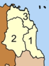
The district is subdivided into 3 subdistricts (tambonTambon
Tambon is a local government unit in Thailand. Below district and province , they form the third administrative subdivision level. As of the 2009 there are 7255 tambon, not including the 169 khwaeng of Bangkok, which are set at the same administrative level, thus every district contains 8-10 tambon...
), which are further subdivided into 34 villages (muban
Muban
Muban is the lowest administrative subdivision of Thailand. Usually translated as village, they are the subdivision of tambon. As of 2008, there are 74944 administrative villages in Thailand. As of the 1990 census, the average village consisted of 144 households or 746 persons.A muban does not...
). Khanom itself has subdistrict municipality (thesaban tambon) status and covers part of tambon Khanom - village 1 and parts of village 3, altogether an area of 1.76 km². The whole tambon Thong Nian forms another subdistrict municipality. The non-municipal area of tambon Khanom and Khuan Thong are each administrated by a Tambon administrative organizations (TAO).
|
 |

