
Arches National Park
Encyclopedia
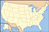
Arches National Park is a U.S. National Park in eastern Utah
. It is known for preserving over 2000 natural sandstone arches
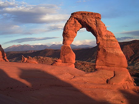
, including the world-famous Delicate Arch
, in addition to a variety of unique geological resources and formations.
The park is located just outside of Moab, Utah
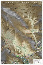
, and is 76679 acres (31,030.9 ha) in area. Its highest elevation is 5653 feet (1,723 m) at Elephant Butte, and its lowest elevation is 4085 feet (1,245.1 m) at the visitor center
. Forty-three arches have collapsed due to erosion
since 1970. The park receives 10 inches (254 mm) of rain a year on average.
Administered by the National Park Service
, the area was originally created as a National Monument on April 12, 1929. It was redesignated as a National Park on November 12, 1971.
 The national park lies atop an underground evaporite
layer or salt
bed, which is the main cause of the formation of the arches, spires, balanced rocks, sandstone
fins, and eroded monoliths in the area. This salt bed is thousands of feet thick in places, and was deposited in the Paradox Basin
of the Colorado Plateau
some 300 million years ago when a sea flowed into the region and eventually evaporated. Over millions of years, the salt bed was covered with debris eroded from the Uncompahgre Uplift
to the northeast. During the Early Jurassic
(about 210 Ma) desert conditions prevailed in the region and the vast Navajo Sandstone
was deposited. An additional sequence of stream laid and windblown sediments, the Entrada Sandstone
(about 140 Ma), was deposited on top of the Navajo. Over 5000 feet (1500 m) of younger sediments were deposited and have been mostly eroded away. Remnants of the cover exist in the area including exposures of the Cretaceous
Mancos Shale
. The arches of the area are developed mostly within the Entrada formation.
The weight of this cover caused the salt bed below it to liquefy and thrust up layers of rock into salt dome
s. The evaporites of the area formed more unusual salt anticline
s or linear regions of uplift. Faulting occurred and whole sections of rock subsided into the areas between the domes. In some places, they turned almost on edge. The result of one such 2500 feet (762 m) displacement, the Moab Fault
, is seen from the visitor center.
As this subsurface movement of salt shaped the landscape, erosion
removed the younger rock layers from the surface. Except for isolated remnants, the major formations visible in the park today are the salmon-colored Entrada Sandstone
, in which most of the arches form, and the buff-colored Navajo Sandstone
. These are visible in layer cake fashion throughout most of the park. Over time, water seeped into the surface cracks, joints, and folds of these layers. Ice formed in the fissures, expanding and putting pressure on surrounding rock, breaking off bits and pieces. Winds later cleaned out the loose particles. A series of free-standing fins remained. Wind and water attacked these fins until, in some, the cementing material gave way and chunks of rock tumbled out. Many damaged fins collapsed. Others, with the right degree of hardness and balance, survived despite their missing sections. These became the famous arches.
 Humans have occupied the region since the last ice age
10,000 years ago. Fremont people and Ancient Pueblo People lived in the area up until about 700 years ago. Spanish missionaries encountered Ute
and Paiute
tribes in the area when they first came through in 1775, but the first European-Americans to attempt settlement in the area were the Mormon Elk Mountain Mission in 1855, who soon abandoned the area. Ranchers, farmers, and prospectors later settled Moab in the neighboring Riverine Valley in the 1880s. Word of the beauty in the surrounding rock formation
s spread beyond the settlement as a possible tourist destination.
The Arches area was first brought to the attention of the National Park Service by Frank A. Wadleigh, passenger traffic manager of the Denver and Rio Grande Western Railroad
. Wadleigh, accompanied by railroad photographer George L. Beam, visited the area in September 1923 at the invitation of Alexander Ringhoffer, a Hungarian
-born prospector
living in Salt Valley. Ringhoffer had written to the railroad in an effort to interest them in the tourist potential of a scenic area he had discovered the previous year with his two sons and a son-in-law, which he called the "Devil's Garden" (known today as the "Klondike Bluffs"). Wadleigh was impressed by what Ringhoffer showed him, and suggested to Park Service director Stephen T. Mather that the area be made a national monument.
 The following year, additional support for the monument idea came from Laurence Gould, a University of Michigan
graduate student (and future polar explorer) studying the geology
of the nearby La Sal Mountains, who was shown the scenic area by retired local physician Dr. J. W. "Doc" Williams.
A succession of government investigators examined the area, in part due to confusion as to the precise location. In the process, the name "Devil's Garden" was transposed to an area on the opposite side of Salt Valley, and Ringhoffer's original discovery was omitted, while another area nearby, known locally as "The Windows", was included. Designation of the area as a national monument was supported by the Park Service from 1926, but was resisted by President Calvin Coolidge
's Interior Secretary, Hubert Work
. Finally in April 1929, shortly after his inauguration, President Herbert Hoover
signed a presidential proclamation creating Arches National Monument, consisting of two comparatively small, disconnected sections. The purpose of the reservation under the 1906 Antiquities Act
was to protect the arches, spires, balanced rocks, and other sandstone formations for their scientific and educational value. The name "Arches" was suggested by Frank Pinkely, superintendent of the Park Service's southwestern national monuments, following a visit to the Windows section in 1925.
In late 1938, President Franklin D. Roosevelt
signed a proclamation which enlarged Arches to protect additional scenic features and permit development of facilities to promote tourism. A small adjustment was made by President Dwight Eisenhower in 1960 to accommodate a new road alignment.
In early 1969, just before leaving office, President Lyndon B. Johnson
signed a proclamation substantially enlarging Arches. Two years later, President Richard Nixon
signed legislation enacted by Congress
which significantly reduced the total area enclosed, but changed its status to a National Park.
's successful free climb
on the Delicate Arch
in May 2006, however, the wording of the regulations was deemed unenforceable by the park attorney
. The park revised its regulations as follows in response:
 Climbing on other features in the park is allowed, but regulated. The revised regulations also prohibit slacklining
parkwide. Approved recreational activities include auto touring, backpacking, biking, camping, and hiking, some of which require permits. Guided commercial tours and ranger programs are also available.
Astronomy is also popular in the park due to its dark skies despite the increasing light pollution
from towns like Moab.
was a park ranger
at Arches National Monument where he kept journals that became his book Desert Solitaire
. The success of this book, as well as the rise in adventure-based recreation, has drawn many hikers
, mountain-bikers
, and off-road enthusiasts to the area, but activities are limited within park boundaries: camping, foot hiking (along designated trails), and driving only along marked roads.
 There is an abundance of wildlife
in Arches. The list includes: spadefoot toad
, scrub jay, peregrine falcon
, many kinds of sparrows, red Fox
, desert bighorn sheep
, kangaroo rat
, mule Deer
, mountain lion, midget faded rattlesnake
, yucca moth, many types of cyanobacteria, Western rattlesnake
, and the Western collared lizard.
Plants also dominate the landscape in the park. The list of plants includes: prickly pear cactus, Indian ricegrass
, bunch grasses, cheatgrass, lichen
, moss
, liverworts
, Utah juniper, Mormon tea, blackbrush, cliffrose, four-winged saltbrush
, pinyon pine
, stemless woollybase, evening primrose
, sand verbena, yucca
, and sacred datura
.
Utah
Utah is a state in the Western United States. It was the 45th state to join the Union, on January 4, 1896. Approximately 80% of Utah's 2,763,885 people live along the Wasatch Front, centering on Salt Lake City. This leaves vast expanses of the state nearly uninhabited, making the population the...
. It is known for preserving over 2000 natural sandstone arches
Natural arch
A natural arch or natural bridge is a natural geological formation where a rock arch forms, with an opening underneath. Most natural arches form as a narrow ridge, walled by cliffs, become narrower from erosion, with a softer rock stratum under the cliff-forming stratum gradually eroding out until...
, including the world-famous Delicate Arch
Delicate Arch
Delicate Arch is a tall freestanding natural arch located in Arches National Park near Moab, Utah.It is the most widely-recognized landmark in Arches National Park and is depicted on Utah license plates and on a postage stamp commemorating Utah's centennial anniversary of statehood in 1996...
, in addition to a variety of unique geological resources and formations.
The park is located just outside of Moab, Utah
Moab, Utah
Moab is a city in Grand County, in eastern Utah, in the western United States. The population was 4,779 at the 2000 census. It is the county seat and largest city in Grand County. Moab hosts a large number of tourists every year, mostly visitors to the nearby Arches and Canyonlands National Parks...
, and is 76679 acres (31,030.9 ha) in area. Its highest elevation is 5653 feet (1,723 m) at Elephant Butte, and its lowest elevation is 4085 feet (1,245.1 m) at the visitor center
Visitor center
A visitor center or centre , visitor information center, tourist information center, is a physical location that provides tourist information to the visitors who tour the place or area locally...
. Forty-three arches have collapsed due to erosion
Erosion
Erosion is when materials are removed from the surface and changed into something else. It only works by hydraulic actions and transport of solids in the natural environment, and leads to the deposition of these materials elsewhere...
since 1970. The park receives 10 inches (254 mm) of rain a year on average.
Administered by the National Park Service
National Park Service
The National Park Service is the U.S. federal agency that manages all national parks, many national monuments, and other conservation and historical properties with various title designations...
, the area was originally created as a National Monument on April 12, 1929. It was redesignated as a National Park on November 12, 1971.
Geology
Evaporite
Evaporite is a name for a water-soluble mineral sediment that result from concentration and crystallization by evaporation from an aqueous solution. There are two types of evaporate deposits, marine which can also be described as ocean deposits, and non-marine which are found in standing bodies of...
layer or salt
Salt
In chemistry, salts are ionic compounds that result from the neutralization reaction of an acid and a base. They are composed of cations and anions so that the product is electrically neutral...
bed, which is the main cause of the formation of the arches, spires, balanced rocks, sandstone
Sandstone
Sandstone is a sedimentary rock composed mainly of sand-sized minerals or rock grains.Most sandstone is composed of quartz and/or feldspar because these are the most common minerals in the Earth's crust. Like sand, sandstone may be any colour, but the most common colours are tan, brown, yellow,...
fins, and eroded monoliths in the area. This salt bed is thousands of feet thick in places, and was deposited in the Paradox Basin
Paradox Basin
The Paradox Basin is an asymmetric foreland basin located mostly in southeast Utah and southwest Colorado, but extending into northeast Arizona and northwest New Mexico. The basin is a large elongate northwest to southeast oriented depression formed during the late Paleozoic Era...
of the Colorado Plateau
Colorado Plateau
The Colorado Plateau, also called the Colorado Plateau Province, is a physiographic region of the Intermontane Plateaus, roughly centered on the Four Corners region of the southwestern United States. The province covers an area of 337,000 km2 within western Colorado, northwestern New Mexico,...
some 300 million years ago when a sea flowed into the region and eventually evaporated. Over millions of years, the salt bed was covered with debris eroded from the Uncompahgre Uplift
Uncompahgre Plateau
The Uncompahgre Plateau in western Colorado is a distinctive large uplift part of the Colorado Plateau. Uncompahgre is a Ute Indian word that describes the water: "Dirty Water" or "Rocks that make Water Red"....
to the northeast. During the Early Jurassic
Jurassic
The Jurassic is a geologic period and system that extends from about Mya to Mya, that is, from the end of the Triassic to the beginning of the Cretaceous. The Jurassic constitutes the middle period of the Mesozoic era, also known as the age of reptiles. The start of the period is marked by...
(about 210 Ma) desert conditions prevailed in the region and the vast Navajo Sandstone
Navajo Sandstone
Navajo Sandstone is a geologic formation in the Glen Canyon Group that is spread across the U.S. states of northern Arizona, northwest Colorado, and Utah; as part of the Colorado Plateau province of the United States...
was deposited. An additional sequence of stream laid and windblown sediments, the Entrada Sandstone
Entrada Sandstone
The Entrada Sandstone is a formation in the San Rafael Group that is spread across the U.S. states of Wyoming, Colorado, northwest New Mexico, northeast Arizona and southeast Utah...
(about 140 Ma), was deposited on top of the Navajo. Over 5000 feet (1500 m) of younger sediments were deposited and have been mostly eroded away. Remnants of the cover exist in the area including exposures of the Cretaceous
Cretaceous
The Cretaceous , derived from the Latin "creta" , usually abbreviated K for its German translation Kreide , is a geologic period and system from circa to million years ago. In the geologic timescale, the Cretaceous follows the Jurassic period and is followed by the Paleogene period of the...
Mancos Shale
Mancos Shale
The Mancos Shale or Mancos Group is an Upper Cretaceous geologic formation of the Western United States dominated by mudrock that accumulated in offshore and marine environments of the Cretaceous North American Inland Sea. The Mancos was deposited during the Cenomanian through Campanian ages,...
. The arches of the area are developed mostly within the Entrada formation.
The weight of this cover caused the salt bed below it to liquefy and thrust up layers of rock into salt dome
Salt dome
A salt dome is a type of structural dome formed when a thick bed of evaporite minerals found at depth intrudes vertically into surrounding rock strata, forming a diapir....
s. The evaporites of the area formed more unusual salt anticline
Anticline
In structural geology, an anticline is a fold that is convex up and has its oldest beds at its core. The term is not to be confused with antiform, which is a purely descriptive term for any fold that is convex up. Therefore if age relationships In structural geology, an anticline is a fold that is...
s or linear regions of uplift. Faulting occurred and whole sections of rock subsided into the areas between the domes. In some places, they turned almost on edge. The result of one such 2500 feet (762 m) displacement, the Moab Fault
Moab Fault
The Moab Fault, near Moab, Utah, USA is a well exposed and much studied geological fault. The Moab fault is an extensional fault that runs approximately NW-SE, passing to the west of the Arches National Park...
, is seen from the visitor center.
As this subsurface movement of salt shaped the landscape, erosion
Erosion
Erosion is when materials are removed from the surface and changed into something else. It only works by hydraulic actions and transport of solids in the natural environment, and leads to the deposition of these materials elsewhere...
removed the younger rock layers from the surface. Except for isolated remnants, the major formations visible in the park today are the salmon-colored Entrada Sandstone
Entrada Sandstone
The Entrada Sandstone is a formation in the San Rafael Group that is spread across the U.S. states of Wyoming, Colorado, northwest New Mexico, northeast Arizona and southeast Utah...
, in which most of the arches form, and the buff-colored Navajo Sandstone
Navajo Sandstone
Navajo Sandstone is a geologic formation in the Glen Canyon Group that is spread across the U.S. states of northern Arizona, northwest Colorado, and Utah; as part of the Colorado Plateau province of the United States...
. These are visible in layer cake fashion throughout most of the park. Over time, water seeped into the surface cracks, joints, and folds of these layers. Ice formed in the fissures, expanding and putting pressure on surrounding rock, breaking off bits and pieces. Winds later cleaned out the loose particles. A series of free-standing fins remained. Wind and water attacked these fins until, in some, the cementing material gave way and chunks of rock tumbled out. Many damaged fins collapsed. Others, with the right degree of hardness and balance, survived despite their missing sections. These became the famous arches.
Climate
Temperatures in Arches National Park vary by month, as does the precipitation. Generally, the hottest month is July. The coolest month is January. October sees the most precipitation in the park. Snow is not an uncommon thing to see during the winter months.History
Ice age
An ice age or, more precisely, glacial age, is a generic geological period of long-term reduction in the temperature of the Earth's surface and atmosphere, resulting in the presence or expansion of continental ice sheets, polar ice sheets and alpine glaciers...
10,000 years ago. Fremont people and Ancient Pueblo People lived in the area up until about 700 years ago. Spanish missionaries encountered Ute
Ute Tribe
The Ute are an American Indian people now living primarily in Utah and Colorado. There are three Ute tribal reservations: Uintah-Ouray in northeastern Utah ; Southern Ute in Colorado ; and Ute Mountain which primarily lies in Colorado, but extends to Utah and New Mexico . The name of the state of...
and Paiute
Paiute
Paiute refers to three closely related groups of Native Americans — the Northern Paiute of California, Idaho, Nevada and Oregon; the Owens Valley Paiute of California and Nevada; and the Southern Paiute of Arizona, southeastern California and Nevada, and Utah.-Origin of name:The origin of...
tribes in the area when they first came through in 1775, but the first European-Americans to attempt settlement in the area were the Mormon Elk Mountain Mission in 1855, who soon abandoned the area. Ranchers, farmers, and prospectors later settled Moab in the neighboring Riverine Valley in the 1880s. Word of the beauty in the surrounding rock formation
Rock formation
This is a list of rock formations that include isolated, scenic, or spectacular surface rock outcrops. These formations are usually the result of weathering and erosion sculpting the existing rock...
s spread beyond the settlement as a possible tourist destination.
The Arches area was first brought to the attention of the National Park Service by Frank A. Wadleigh, passenger traffic manager of the Denver and Rio Grande Western Railroad
Denver and Rio Grande Western Railroad
The Denver & Rio Grande Western Railroad , often shortened to Rio Grande or D&RGW, formerly the Denver & Rio Grande Railroad, is a defunct U.S. railroad company. The railroad started as a narrow gauge line running south from Denver, Colorado in 1870; however, served mainly as a transcontinental...
. Wadleigh, accompanied by railroad photographer George L. Beam, visited the area in September 1923 at the invitation of Alexander Ringhoffer, a Hungarian
Hungary
Hungary , officially the Republic of Hungary , is a landlocked country in Central Europe. It is situated in the Carpathian Basin and is bordered by Slovakia to the north, Ukraine and Romania to the east, Serbia and Croatia to the south, Slovenia to the southwest and Austria to the west. The...
-born prospector
Prospecting
Prospecting is the physical search for minerals, fossils, precious metals or mineral specimens, and is also known as fossicking.Prospecting is a small-scale form of mineral exploration which is an organised, large scale effort undertaken by mineral resource companies to find commercially viable ore...
living in Salt Valley. Ringhoffer had written to the railroad in an effort to interest them in the tourist potential of a scenic area he had discovered the previous year with his two sons and a son-in-law, which he called the "Devil's Garden" (known today as the "Klondike Bluffs"). Wadleigh was impressed by what Ringhoffer showed him, and suggested to Park Service director Stephen T. Mather that the area be made a national monument.
University of Michigan
The University of Michigan is a public research university located in Ann Arbor, Michigan in the United States. It is the state's oldest university and the flagship campus of the University of Michigan...
graduate student (and future polar explorer) studying the geology
Geology
Geology is the science comprising the study of solid Earth, the rocks of which it is composed, and the processes by which it evolves. Geology gives insight into the history of the Earth, as it provides the primary evidence for plate tectonics, the evolutionary history of life, and past climates...
of the nearby La Sal Mountains, who was shown the scenic area by retired local physician Dr. J. W. "Doc" Williams.
A succession of government investigators examined the area, in part due to confusion as to the precise location. In the process, the name "Devil's Garden" was transposed to an area on the opposite side of Salt Valley, and Ringhoffer's original discovery was omitted, while another area nearby, known locally as "The Windows", was included. Designation of the area as a national monument was supported by the Park Service from 1926, but was resisted by President Calvin Coolidge
Calvin Coolidge
John Calvin Coolidge, Jr. was the 30th President of the United States . A Republican lawyer from Vermont, Coolidge worked his way up the ladder of Massachusetts state politics, eventually becoming governor of that state...
's Interior Secretary, Hubert Work
Hubert Work
Hubert Work was a U.S. administrator and physician. He served as the Postmaster General between 1922 and 1923 in the presidency of Warren G. Harding. He then served as the Secretary of the Interior from 1923-1928 during the administration of Calvin Coolidge.Work was born in Marion Center,...
. Finally in April 1929, shortly after his inauguration, President Herbert Hoover
Herbert Hoover
Herbert Clark Hoover was the 31st President of the United States . Hoover was originally a professional mining engineer and author. As the United States Secretary of Commerce in the 1920s under Presidents Warren Harding and Calvin Coolidge, he promoted partnerships between government and business...
signed a presidential proclamation creating Arches National Monument, consisting of two comparatively small, disconnected sections. The purpose of the reservation under the 1906 Antiquities Act
Antiquities Act
The Antiquities Act of 1906, officially An Act for the Preservation of American Antiquities , is an act passed by the United States Congress and signed into law by Theodore Roosevelt on June 8, 1906, giving the President of the United States authority to, by executive order, restrict the use of...
was to protect the arches, spires, balanced rocks, and other sandstone formations for their scientific and educational value. The name "Arches" was suggested by Frank Pinkely, superintendent of the Park Service's southwestern national monuments, following a visit to the Windows section in 1925.
In late 1938, President Franklin D. Roosevelt
Franklin D. Roosevelt
Franklin Delano Roosevelt , also known by his initials, FDR, was the 32nd President of the United States and a central figure in world events during the mid-20th century, leading the United States during a time of worldwide economic crisis and world war...
signed a proclamation which enlarged Arches to protect additional scenic features and permit development of facilities to promote tourism. A small adjustment was made by President Dwight Eisenhower in 1960 to accommodate a new road alignment.
In early 1969, just before leaving office, President Lyndon B. Johnson
Lyndon B. Johnson
Lyndon Baines Johnson , often referred to as LBJ, was the 36th President of the United States after his service as the 37th Vice President of the United States...
signed a proclamation substantially enlarging Arches. Two years later, President Richard Nixon
Richard Nixon
Richard Milhous Nixon was the 37th President of the United States, serving from 1969 to 1974. The only president to resign the office, Nixon had previously served as a US representative and senator from California and as the 36th Vice President of the United States from 1953 to 1961 under...
signed legislation enacted by Congress
United States Congress
The United States Congress is the bicameral legislature of the federal government of the United States, consisting of the Senate and the House of Representatives. The Congress meets in the United States Capitol in Washington, D.C....
which significantly reduced the total area enclosed, but changed its status to a National Park.
Recreational activities
Climbing on named arches within the park has long been banned by park regulations. Following Dean PotterDean Potter
Dean Potter is an American free climber, alpinist, BASE jumper, BASEliner, and highliner. He is noted for hard first ascents, free solo ascents, speed ascents, and enchainments in Yosemite and Patagonia....
's successful free climb
Free climbing
Free climbing is a type of rock climbing in which the climber uses only hands, feet and other parts of the body to ascend, employing ropes and forms of climbing protection to prevent falls only....
on the Delicate Arch
Delicate Arch
Delicate Arch is a tall freestanding natural arch located in Arches National Park near Moab, Utah.It is the most widely-recognized landmark in Arches National Park and is depicted on Utah license plates and on a postage stamp commemorating Utah's centennial anniversary of statehood in 1996...
in May 2006, however, the wording of the regulations was deemed unenforceable by the park attorney
Lawyer
A lawyer, according to Black's Law Dictionary, is "a person learned in the law; as an attorney, counsel or solicitor; a person who is practicing law." Law is the system of rules of conduct established by the sovereign government of a society to correct wrongs, maintain the stability of political...
. The park revised its regulations as follows in response:
Slacklining
Slacklining is a practice in balance that typically uses 1 inch nylon webbing tensioned between two anchor points. Slacklining is distinct from tightrope walking in that the line is not held rigidly taut ; it is instead dynamic, stretching and bouncing like a long and narrow trampoline...
parkwide. Approved recreational activities include auto touring, backpacking, biking, camping, and hiking, some of which require permits. Guided commercial tours and ranger programs are also available.
Astronomy is also popular in the park due to its dark skies despite the increasing light pollution
Light pollution
Light pollution, also known as photopollution or luminous pollution, is excessive or obtrusive artificial light.The International Dark-Sky Association defines light pollution as:...
from towns like Moab.
Publicity
American writer Edward AbbeyEdward Abbey
Edward Paul Abbey was an American author and essayist noted for his advocacy of environmental issues, criticism of public land policies, and anarchist political views. His best-known works include the novel The Monkey Wrench Gang, which has been cited as an inspiration by radical environmental...
was a park ranger
Park ranger
A park ranger or forest ranger is a person entrusted with protecting and preserving parklands – national, state, provincial, or local parks. Different countries use different names for the position. Ranger is the favored term in the United States, Canada, and the United Kingdom. Within the United...
at Arches National Monument where he kept journals that became his book Desert Solitaire
Desert Solitaire
This article is about the book. For the album dedicated to Edward Abbey see Desert Solitaire .Desert Solitaire: A Season in the Wilderness is a literary nonfiction work by Edward Abbey , published originally in 1968....
. The success of this book, as well as the rise in adventure-based recreation, has drawn many hikers
Hiking
Hiking is an outdoor activity which consists of walking in natural environments, often in mountainous or other scenic terrain. People often hike on hiking trails. It is such a popular activity that there are numerous hiking organizations worldwide. The health benefits of different types of hiking...
, mountain-bikers
Mountain bike
A mountain bike or mountain bicycle is a bicycle created for off-road cycling. This activity includes traversing of rocks and washouts, and steep declines,...
, and off-road enthusiasts to the area, but activities are limited within park boundaries: camping, foot hiking (along designated trails), and driving only along marked roads.
Biology
Wildlife
Wildlife includes all non-domesticated plants, animals and other organisms. Domesticating wild plant and animal species for human benefit has occurred many times all over the planet, and has a major impact on the environment, both positive and negative....
in Arches. The list includes: spadefoot toad
American spadefoot toads
Scaphiopodidae is a family of American spadefoot toads. They are native to southern Canada and USA south to southern Mexico. Scaphiopodidae is a small family, comprising only seven species....
, scrub jay, peregrine falcon
Peregrine Falcon
The Peregrine Falcon , also known as the Peregrine, and historically as the Duck Hawk in North America, is a widespread bird of prey in the family Falconidae. A large, crow-sized falcon, it has a blue-gray back, barred white underparts, and a black head and "moustache"...
, many kinds of sparrows, red Fox
Red Fox
The red fox is the largest of the true foxes, as well as being the most geographically spread member of the Carnivora, being distributed across the entire northern hemisphere from the Arctic Circle to North Africa, Central America, and the steppes of Asia...
, desert bighorn sheep
Desert Bighorn Sheep
The Desert Bighorn Sheep is a subspecies of Bighorn Sheep that occurs in the desert Southwest regions of the United States and in the northern regions of Mexico. The trinomial of this species commemorates the American naturalist Edward William Nelson...
, kangaroo rat
Kangaroo rat
Kangaroo rats, genus Dipodomys, are small rodents native to North America. The common name derives from their bipedal form: as they hop in a manner similar to the much larger kangaroo, although they are not related...
, mule Deer
Mule Deer
The mule deer is a deer indigenous to western North America. The Mule Deer gets its name from its large mule-like ears. There are believed to be several subspecies, including the black-tailed deer...
, mountain lion, midget faded rattlesnake
Crotalus oreganus concolor
Crotalus oreganus concolor is a venomous pitviper subspecies found in the western United States. A small species known for its faded color pattern.-Description:Grows to a maximum length of 750 mm...
, yucca moth, many types of cyanobacteria, Western rattlesnake
Crotalus viridis
Crotalus viridis is a venomous pitviper species native to the western United States, southwestern Canada, and northern Mexico. Currently, nine subspecies are recognized, including the nominate subspecies described here.-Description:...
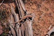
, and the Western collared lizard.
Plants also dominate the landscape in the park. The list of plants includes: prickly pear cactus, Indian ricegrass
Indian ricegrass
Oryzopsis hymenoides is a perennial cool-season bunchgrass. It is native to western North America east of the Cascades from British Columbia and Alberta south to southern California, northeastern Mexico, and Texas...
, bunch grasses, cheatgrass, lichen
Lichen
Lichens are composite organisms consisting of a symbiotic organism composed of a fungus with a photosynthetic partner , usually either a green alga or cyanobacterium...
, moss
Moss
Mosses are small, soft plants that are typically 1–10 cm tall, though some species are much larger. They commonly grow close together in clumps or mats in damp or shady locations. They do not have flowers or seeds, and their simple leaves cover the thin wiry stems...
, liverworts
Marchantiophyta
The Marchantiophyta are a division of bryophyte plants commonly referred to as hepatics or liverworts. Like other bryophytes, they have a gametophyte-dominant life cycle, in which cells of the plant carry only a single set of genetic information....
, Utah juniper, Mormon tea, blackbrush, cliffrose, four-winged saltbrush
Atriplex canescens
Atriplex canescens, Chamiso, Chamiza, Four wing saltbush, Four-wing saltbush, and Fourwing saltbush, is a species of evergreen shrub in the Amaranthaceae family, which is native to the western and mid-western United States....
, pinyon pine
Pinyon pine
The pinyon pine group grows in the southwestern United States and in Mexico. The trees yield edible pinyon nuts, which were a staple of the Native Americans, and are still widely eaten...
, stemless woollybase, evening primrose
Oenothera
Oenothera is a Genus of about 125 species of annual, biennial and perennial herbaceous flowering plants, native to North and South America. It is the type genus of the family Onagraceae, the Evening Primrose Family. Common names include evening-primrose, suncups, and sundrops.The species vary in...
, sand verbena, yucca
Yucca
Yucca is a genus of perennial shrubs and trees in the family Asparagaceae, subfamily Agavoideae. Its 40-50 species are notable for their rosettes of evergreen, tough, sword-shaped leaves and large terminal panicles of white or whitish flowers. They are native to the hot and dry parts of North...
, and sacred datura
Datura wrightii
Datura wrightii or Sacred Datura is the name of a poisonous perennial plant and ornamental flower of southwestern North America. It is sometimes used as a hallucinogen. Datura wrightii is classified as a deliriant and an anticholinergic....
.
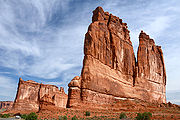
Features
Among the notable features of the park are:- Balanced RockBalanced RockBalanced Rock is one of the most popular features of Arches National Park, situated in Grand County, Utah, United States. Balanced Rock is located next to the park's main road, at about 9 miles from the park entrance....
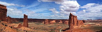
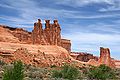
– a large balancing rock, the size of three school buses - Courthouse TowersCourthouse TowersThe Courthouse Towers is a collection of tall stone columns located in Arches National Park....
– a collection of tall stone columns - Dark Angel – a free-standing 150 feet (45.7 m) tall sandstone pillar at the end of the Devil's Garden Trail
- Delicate ArchDelicate ArchDelicate Arch is a tall freestanding natural arch located in Arches National Park near Moab, Utah.It is the most widely-recognized landmark in Arches National Park and is depicted on Utah license plates and on a postage stamp commemorating Utah's centennial anniversary of statehood in 1996...
– a lone-standing arch which has become a symbol of Utah - Devil's GardenDevil's GardenDevil's Garden is an area of Arches National Park, located near Moab, Utah, that features a series of rock fins that have broken out of the earth due to erosion and produce many spectacular views...
– with many arches and columns scattered along a ridge - Double ArchDouble ArchDouble Arch is a close-set pair of natural arches, one of the more known features of Arches National Park in Utah, United States. From the Double Arch parking area it's a 0.5 mile round trip to the arches...
– two arches that share a common end - Fiery Furnace – an area of maze-like narrow passages and tall rock columns (see biblical reference Fiery FurnaceFiery furnaceFiery furnace may refer to:* The fiery furnace in which Shadrach, Meshach, and Abednego were thrown into in Daniel 3* Fiery Furnace , a region of Utah's Arches National Park* The Fiery Furnaces, a rock band...
) - Landscape ArchLandscape ArchLandscape Arch is the longest of the many natural rock arches located in the Arches National Park in Utah, USA. The arch is among many in the area known as Devil's Garden in the north area of the park...
– a very thin and long arch with a span of 290 feet (88.4 m) - Petrified dunesPetrified dunesThe Petrified Dunes are a series of rock formations located in Arches National Park. The dunes can be found just off of the park road between the Courthouse Towers and the Windows Area. The formation was produced when ancient sand dunes hardened into stone under the overlying subsequent material,...
– petrified remnants of sand dunes blown from the ancient lakes that covered the area - Wall ArchWall ArchWall Arch was a natural sandstone arch in the Arches National Park in the U.S. state of Utah. Before its collapse in 2008, it was ranked 12th in size among the park's over 2,000 arches. At its largest, the opening underneath the span was wide by high. It consisted of Entrada Sandstone,...
– located along the popular Devil's Garden Trail; collapsed sometime on August 4/5, 2008
See also
- Natural Bridges National MonumentNatural Bridges National MonumentNatural Bridges National Monument is a U.S. National Monument located about north west of the Four Corners boundary of southeast Utah, in the western United States, at the junction of White Canyon and Armstrong Canyon, part of the Colorado River drainage...
featuring water-eroded bridges instead of wind-eroded arches - Rainbow Bridge National MonumentRainbow Bridge National MonumentRainbow Bridge National Monument is administered by Glen Canyon National Recreation Area, southern Utah, USA. Rainbow Bridge is often described as the world's highest natural bridge. The span of Rainbow Bridge was reported in 1974 by the Bureau of Reclamation to be , but a laser measurement in...
- National Register of Historic Places listings in Arches National ParkNational Register of Historic Places listings in Arches National ParkThis is a list of the National Register of Historic Places listings in Arches National Park.This is intended to be a complete list of the properties and districts on the National Register of Historic Places in Arches National Park, Utah, United States...