

Bianco world map
Encyclopedia
Rule of marteloio
thumb|300px|The tondo e quadro from [[Andrea Bianco]]'s 1436 atlasThe rule of marteloio is a medieval technique of navigational computation that uses compass direction, distance and a simple trigonometric table known as the toleta de marteloio...
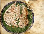
for resolving the course, with the "circle and square", two tables and two other diagrams. The next eight leaves contain various navigation charts. The ninth leaf contains a circular world map measuring 25 cm in circumference.
And the final leaf contains the Ptolemaic world map on Ptolemy
Ptolemy
Claudius Ptolemy , was a Roman citizen of Egypt who wrote in Greek. He was a mathematician, astronomer, geographer, astrologer, and poet of a single epigram in the Greek Anthology. He lived in Egypt under Roman rule, and is believed to have been born in the town of Ptolemais Hermiou in the...
's first projection, with graduation. Bianco also collaborated with Fra Mauro
Fra Mauro
Fra Mauro, O.S.B. Cam., was a 15th-century Camaldolese monk who lived in the Republic of Venice. He was a monk of the Monastery of St. Michael, located on the island of Murano in the Venetian Lagoon. It was there that he maintained a cartography workshop.In his youth, Mauro had traveled...
on the Fra Mauro world map
Fra Mauro map
The Fra Mauro map, "considered the greatest memorial of medieval cartography" according to Roberto Almagià, is a map made around 1450 by the Venetian monk Fra Mauro...
of 1459.