Bicycle-friendly
Encyclopedia
The term bicycle-friendly describes policies and practices which may help some people feel more comfortable about traveling by bicycle
with other traffic. The level of bicycle-friendliness of an environment can be influenced by many factors resulting from town planning and cycling infrastructure
decisions.
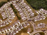
may have an impact on whether schools, shops, public transport interchanges and other destination are within a reasonable cycling distance of the areas where people live. If urban form influences these issues, then compact and circular settlement patterns
as in Elizabeth, NJ may promote cycling. Alternatively, the low-density, non-circular (i.e., linear) settlement patterns characteristic of urban sprawl
as in nearby Downtown Newark
tends to discourage cycling. In 1990, the Dutch adopted the "ABC" guidelines, specifically limiting developments that are major attractants to locations that are readily accessible by non-car users.
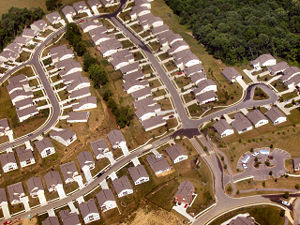 The manner in which the public roads network is designed, built and managed can have a significant effect on the utility and safety of cycling as transport. Settlements that provide a dense roads network consisting of interconnected street
s will tend to encourage cycling.
In contrast, other communities may use a cul-de-sac
based, housing estate
/housing subdivision model where minor roads are disconnected and only feed into a street hierarchy
of progressively more "arterial" type roads. Designs that propose to resolve the contradiction between the cul-de-sac and the traditional interconnected network, such as the Fused Grid
, have been proposed and built with varying levels of success.
In the UK, the principle of 'filtered permeability' has been proposed in some Government guidance, to maximise the ease of movement of cyclists and pedestrians, whilst constraining it for motor vehicles (see: Permeability (spatial and transport planning)
).
comprises the public ways available to cyclists. This includes the network of street
s and public roads used by motorized vehicles, minus those road
s from which cyclists have been banned (most motorways or freeways), plus additional bikeway
s that are not available normally to motorized vehicles, such as foreshoreway
s, greenway
s, rail trail
s, cycle tracks, bike lanes and road shoulders. In addition, some jurisdictions permit bicycling on sidewalk
s.
Aspects of the cycling infrastructure may be viewed as either cyclist-hostile or as cyclist-friendly. In general, roads infrastructure based on prioritising certain routes in an attempt to create a state of constant "flow" for vehicles on that route, will tend to be hostile to those not on that route. In 1996, the British Cyclists Touring Club (CTC)
and the Institute for Highways and Transportation jointly produced the document "Cycle-friendly infrastructure: Guidelines for planning and design". This defined a hierarchy of measures for cycling promotion in which the goal is to convert a more or less cyclist-hostile roads infrastructure into one which encourages and facilitates cycling.

and ring roads around urban centres.
Traffic reduction can involve direct or indirect methods. A proven indirect method of reducing motor traffic, and facilitating cyclist and pedestrian use, is to adopt the shared space
system. This system, by giving equal priority to all road users, and by removing conventional road markings, road signs and road conventions, capitalises on the tendency for all road users to respect and trust each other when they are interacting on an equal basis. No explicit, or even implicit priority is given to traffic travelling along the road, so with no assumptions of priority being possible, all road users need to be aware of all other road users at all times.
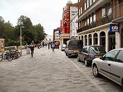 New Road in Brighton
was remodelled using this philosophy, and the results were a 93% reduction in motor traffic and a 22% increase in cycling traffic. Other indirect methods involve reducing the infrastructural capacity dedicated to moving or storing road vehicle. This can involve reducing the number of road lanes, closing bridges to certain vehicle types and creating vehicle restricted zones or environmental traffic cells. In the 1970s the Dutch city of Delft
began restricting private car traffic from crossing the city centre. Similarly, Groningen is divided into four zones that cannot be crossed by private motor-traffic, (private cars must use the ring road instead). Cyclists and other traffic can pass between the zones and cycling accounts for 50%+ of trips in Groningen (which reputedly has the third highest proportion of cycle traffic of any city). The Swedish city of Gothenburg
uses a similar system of traffic cells. Starting in the 1970s, the city of Copenhagen
, which is noted for high cycling levels, adopted a policy of reducing available car parking capacity by several per cent a year. The city of Amsterdam
, where around 40% of all trips are by bicycle, adopted similar parking reduction policies in the 80s and 90s.
Direct traffic reduction methods can involve straightforward bans or more subtle methods like road pricing
schemes or road diet
s. The London congestion charge
reportedly resulted in a significant increase in cycle use within the affected area.
Traffic calming
Speed reduction has traditionally been attempted by statutory speed limit
s.
Recent implementations of shared space
schemes have delivered significant traffic speed reductions. The reductions are sustainable, without the need for speed limits or speed limit enforcement. In Norrköping
, mean traffic speeds in 2006 dropped from 21 to 16 km/h (13 to 10 mph) since the implementation of such a scheme.
Even without shared street implementation, creating 30 kph zones
(or 20 mph zones
) has been shown to reduce crash rates and increase numbers of cyclists and pedestrians. Other studies have revealed that lower speeds reduce community severance caused by high speed roads. Research has shown that there is more neighborhood interaction and community cohesion when speeds are reduced to 20 mph.
One-way streets
German research indicates that making one-way streets two-way for cyclists results in a reduction in the total number of collisions. In Belgium
, all one-way streets in 50 km/h zones are by default two-way for cyclists.
A Danish
road directorate states that in town centres it is important to be able to cycle in both directions in all streets, and that in certain circumstances, two-way cycle traffic can be accommodated in an otherwise one-way street.
Junction design
On large roundabouts of the design typically used in the UK and Ireland, cyclists have an injury accident rate that is 14-16 times that of motorists. Research indicates that excessive sightlines at uncontrolled intersections compound these effects. In the UK, a survey of over 8,000 highly experienced and mainly adult male Cyclists' Touring Club
members found that 28% avoided roundabouts on their regular journey if at all possible.
Traffic signals/Traffic control systems
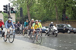
How traffic signals are designed and implemented directly impacts cyclists.
Coexistence with other road users
Several methods of altering or reallocation of the carriageway (UK) or roadway (USA) to decrease the potential for social friction during overtaking and passing have been added to many of the manuals used by designers.
and physical activity. Cities that incorporate bicycle routes have a higher percentage of bicycle commuters. Studies have shown that even moderate increases in physical activity can have a substantial impact on health. Bicycling to work has been shown to decrease mortality by as much as 40%.
Bicycling is often used as an alternative to travel by car. Automobile travel provides increased mobility and convenience for travelers, but also has high costs associated with taxes, insurance, gas, maintenance, road construction and repair, and contributes to air pollution. When infrastructure is built to allow consumers to choose between automobile and other forms of travel, it reduces a community's automobile dependency
and allows for more efficient land usage.
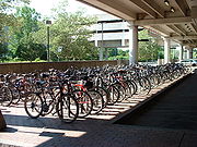
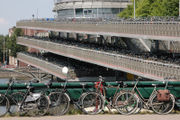 See Bicycle transportation engineering#Parking
has formally recognized some cities as bicycle-friendly communities for "providing safe accommodation and facilities for bicyclists and encouraging residents to bike for transportation and recreation."
Bicycle
A bicycle, also known as a bike, pushbike or cycle, is a human-powered, pedal-driven, single-track vehicle, having two wheels attached to a frame, one behind the other. A person who rides a bicycle is called a cyclist, or bicyclist....
with other traffic. The level of bicycle-friendliness of an environment can be influenced by many factors resulting from town planning and cycling infrastructure
Cycling infrastructure
The cycling infrastructure comprises all the public ways that are available to cyclists travelling from one destination to another. This includes the same network of public roads that is available for other road vehicle users, minus those roads from which cyclists have been banned , plus additional...
decisions.
Town planning
Assuming people prefer to get to their destination quickly, town planning and zoningZoning
Zoning is a device of land use planning used by local governments in most developed countries. The word is derived from the practice of designating permitted uses of land based on mapped zones which separate one set of land uses from another...
may have an impact on whether schools, shops, public transport interchanges and other destination are within a reasonable cycling distance of the areas where people live. If urban form influences these issues, then compact and circular settlement patterns
Population geography
Population geography is a division of human geography. It is the study of the ways in which spatial variations in the distribution, composition, migration, and growth of populations are related to the nature of places. Population geography involves demography in a geographical perspective. It...
as in Elizabeth, NJ may promote cycling. Alternatively, the low-density, non-circular (i.e., linear) settlement patterns characteristic of urban sprawl
Urban sprawl
Urban sprawl, also known as suburban sprawl, is a multifaceted concept, which includes the spreading outwards of a city and its suburbs to its outskirts to low-density and auto-dependent development on rural land, high segregation of uses Urban sprawl, also known as suburban sprawl, is a...
as in nearby Downtown Newark
Downtown Newark
Downtown Newark is Newark, New Jersey's major central business, retail, and cultural district. It is located at a bend in the Passaic River.Downtown is the site of the original Puritan settlement of Newark. The first settlers, led by Robert Treat, landed not far from the present site of the New...
tends to discourage cycling. In 1990, the Dutch adopted the "ABC" guidelines, specifically limiting developments that are major attractants to locations that are readily accessible by non-car users.

Grid plan
The grid plan, grid street plan or gridiron plan is a type of city plan in which streets run at right angles to each other, forming a grid...
s will tend to encourage cycling.
In contrast, other communities may use a cul-de-sac
Cul-de-sac
A cul-de-sac is a word of French origin referring to a dead end, close, no through road or court meaning dead-end street with only one inlet/outlet...
based, housing estate
Housing estate
A housing estate is a group of buildings built together as a single development. The exact form may vary from country to country. Accordingly, a housing estate is usually built by a single contractor, with only a few styles of house or building design, so they tend to be uniform in appearance...
/housing subdivision model where minor roads are disconnected and only feed into a street hierarchy
Street hierarchy
The street hierarchy is an urban design technique for laying out road networks that exclude automobile through-traffic from developed areas. It is conceived as a hierarchy of roads that embeds the link importance of each road type in the network topology...
of progressively more "arterial" type roads. Designs that propose to resolve the contradiction between the cul-de-sac and the traditional interconnected network, such as the Fused Grid
Fused Grid
The Fused Grid is a street network pattern first proposed in 2002 and subsequently applied in Calgary, Alberta and in Stratford, Ontario . It represents a synthesis of two well known and extensively used network concepts: the "grid" and the “Radburn” pattern, derivatives of which are found in most...
, have been proposed and built with varying levels of success.
In the UK, the principle of 'filtered permeability' has been proposed in some Government guidance, to maximise the ease of movement of cyclists and pedestrians, whilst constraining it for motor vehicles (see: Permeability (spatial and transport planning)
Permeability (spatial and transport planning)
Permeability or connectivity describes the extent to which urban forms permit movement of people or vehicles in different directions. The terms are often used interchangeably, although differentiated definitions also exist...
).
Cycling infrastructure
The cycling infrastructureInfrastructure
Infrastructure is basic physical and organizational structures needed for the operation of a society or enterprise, or the services and facilities necessary for an economy to function...
comprises the public ways available to cyclists. This includes the network of street
Street
A street is a paved public thoroughfare in a built environment. It is a public parcel of land adjoining buildings in an urban context, on which people may freely assemble, interact, and move about. A street can be as simple as a level patch of dirt, but is more often paved with a hard, durable...
s and public roads used by motorized vehicles, minus those road
Road
A road is a thoroughfare, route, or way on land between two places, which typically has been paved or otherwise improved to allow travel by some conveyance, including a horse, cart, or motor vehicle. Roads consist of one, or sometimes two, roadways each with one or more lanes and also any...
s from which cyclists have been banned (most motorways or freeways), plus additional bikeway
Bikeway
A Bikeway is a route, way or path which in some manner is specifically designed and /or designated for bicycle travel.-See also:*Bicycle boulevard*Bicycle trail*Bicycle transportation engineering*Foreshoreway*Greenway* List of cycleways...
s that are not available normally to motorized vehicles, such as foreshoreway
Foreshoreway
A foreshoreway is a type of greenway that provides a public right of way along the edge of a waterbody.Foreshoreways are usually focused on sustainable behaviours and hence are a common facility for sustainable transport. The terminology was derived to assist to avoid the perception of a pavement...
s, greenway
Greenway (landscape)
A greenway is a long, narrow piece of land, often used for recreation and pedestrian and bicycle user traffic, and sometimes for streetcar, light rail or retail uses.- Terminology :...
s, rail trail
Rail trail
A rail trail is the conversion of a disused railway easement into a multi-use path, typically for walking, cycling and sometimes horse riding. The characteristics of former tracks—flat, long, frequently running through historical areas—are appealing for various development. The term sometimes also...
s, cycle tracks, bike lanes and road shoulders. In addition, some jurisdictions permit bicycling on sidewalk
Sidewalk
A sidewalk, or pavement, footpath, footway, and sometimes platform, is a path along the side of a road. A sidewalk may accommodate moderate changes in grade and is normally separated from the vehicular section by a curb...
s.
Aspects of the cycling infrastructure may be viewed as either cyclist-hostile or as cyclist-friendly. In general, roads infrastructure based on prioritising certain routes in an attempt to create a state of constant "flow" for vehicles on that route, will tend to be hostile to those not on that route. In 1996, the British Cyclists Touring Club (CTC)
Cyclists' Touring Club
CTC and the UK's national cyclists' organisation are the trading names of the Cyclists' Touring Club.CTC is the United Kingdom's largest cycling membership organisation. It also has member groups in the Republic of Ireland...
and the Institute for Highways and Transportation jointly produced the document "Cycle-friendly infrastructure: Guidelines for planning and design". This defined a hierarchy of measures for cycling promotion in which the goal is to convert a more or less cyclist-hostile roads infrastructure into one which encourages and facilitates cycling.

The CTC/IHT hierarchy
- Traffic reduction. Can motor traffic levels, particularly of heavy vehicles, be reduced?
- Traffic calming. Can speed be reduced and driver behaviour modified?
- Junction treatment and traffic management. These measures include:
- Urban traffic control systems designed to recognise cyclists and give them priority.
- Exempt cyclists from banned turns and access restrictions.
- Provide contra-flow cycle lanes on one-way streets.
- Implement on-street parking restrictions.
- Provide advanced stop lineAdvanced stop lineAn advanced stop line , also called advanced stop box or bike box, these are road markings at signalised road junctions allowing certain types of vehicle a head start when the traffic signal changes from red to green.-Description:...
s/bypasses for cyclists at traffic signals. - Junction alterations, signalise roundabouts, cycle-friendly junction design.
- Redistribution of the carriageway -such as by marking wide curb lanes or shared bus/cycle lanes.
- Cycle lanes and cycle tracks. Having considered and implemented all the above, what cycle tracks or cycle lanes are considered necessary?
Traffic reduction
Removing motor traffic can be achieved by straightforward diversion or alternatively reduction. Diversion involves routing through-traffic away from roads used by high numbers of cyclists and pedestrians. Examples of diversion include the construction of arterial bypassesBypass (road)
A bypass is a road or highway that avoids or "bypasses" a built-up area, town, or village, to let through traffic flow without interference from local traffic, to reduce congestion in the built-up area, and to improve road safety....
and ring roads around urban centres.
Traffic reduction can involve direct or indirect methods. A proven indirect method of reducing motor traffic, and facilitating cyclist and pedestrian use, is to adopt the shared space
Shared space
Shared space is an urban design concept aimed at integrated use of public spaces. It encourages traffic engineers, urban planners and experts from other fields to consult with users of public space when planning and designing streets and squares in both built and non-built environments...
system. This system, by giving equal priority to all road users, and by removing conventional road markings, road signs and road conventions, capitalises on the tendency for all road users to respect and trust each other when they are interacting on an equal basis. No explicit, or even implicit priority is given to traffic travelling along the road, so with no assumptions of priority being possible, all road users need to be aware of all other road users at all times.

Brighton
Brighton is the major part of the city of Brighton and Hove in East Sussex, England on the south coast of Great Britain...
was remodelled using this philosophy, and the results were a 93% reduction in motor traffic and a 22% increase in cycling traffic. Other indirect methods involve reducing the infrastructural capacity dedicated to moving or storing road vehicle. This can involve reducing the number of road lanes, closing bridges to certain vehicle types and creating vehicle restricted zones or environmental traffic cells. In the 1970s the Dutch city of Delft
Delft
Delft is a city and municipality in the province of South Holland , the Netherlands. It is located between Rotterdam and The Hague....
began restricting private car traffic from crossing the city centre. Similarly, Groningen is divided into four zones that cannot be crossed by private motor-traffic, (private cars must use the ring road instead). Cyclists and other traffic can pass between the zones and cycling accounts for 50%+ of trips in Groningen (which reputedly has the third highest proportion of cycle traffic of any city). The Swedish city of Gothenburg
Gothenburg
Gothenburg is the second-largest city in Sweden and the fifth-largest in the Nordic countries. Situated on the west coast of Sweden, the city proper has a population of 519,399, with 549,839 in the urban area and total of 937,015 inhabitants in the metropolitan area...
uses a similar system of traffic cells. Starting in the 1970s, the city of Copenhagen
Copenhagen
Copenhagen is the capital and largest city of Denmark, with an urban population of 1,199,224 and a metropolitan population of 1,930,260 . With the completion of the transnational Øresund Bridge in 2000, Copenhagen has become the centre of the increasingly integrating Øresund Region...
, which is noted for high cycling levels, adopted a policy of reducing available car parking capacity by several per cent a year. The city of Amsterdam
Amsterdam
Amsterdam is the largest city and the capital of the Netherlands. The current position of Amsterdam as capital city of the Kingdom of the Netherlands is governed by the constitution of August 24, 1815 and its successors. Amsterdam has a population of 783,364 within city limits, an urban population...
, where around 40% of all trips are by bicycle, adopted similar parking reduction policies in the 80s and 90s.
Direct traffic reduction methods can involve straightforward bans or more subtle methods like road pricing
Road pricing
Road pricing is an economic concept regarding the various direct charges applied for the use of roads. The road charges includes fuel taxes, licence fees, parking taxes, tolls, and congestion charges, including those which may vary by time of day, by the specific road, or by the specific vehicle...
schemes or road diet
Road diet
A road diet, also called a lane reduction, is a technique in transportation planning whereby a road is reduced in number of travel lanes and/or effective width in order to achieve systemic improvements.-Techniques:...
s. The London congestion charge
London congestion charge
The London congestion charge is a fee charged for some categories of motor vehicle to travel at certain times within the Congestion Charge Zone , a traffic area in London. The charge aims to reduce congestion, and raise investment funds for London's transport system...
reportedly resulted in a significant increase in cycle use within the affected area.
Traffic calming
Speed reduction has traditionally been attempted by statutory speed limit
Speed limit
Road speed limits are used in most countries to regulate the speed of road vehicles. Speed limits may define maximum , minimum or no speed limit and are normally indicated using a traffic sign...
s.
Recent implementations of shared space
Shared space
Shared space is an urban design concept aimed at integrated use of public spaces. It encourages traffic engineers, urban planners and experts from other fields to consult with users of public space when planning and designing streets and squares in both built and non-built environments...
schemes have delivered significant traffic speed reductions. The reductions are sustainable, without the need for speed limits or speed limit enforcement. In Norrköping
Norrköping
Norrköping is a city in the province of Östergötland in eastern Sweden and the seat of Norrköping Municipality, Östergötland County. The city has a population of 87,247 inhabitants in 2010, out of a municipal total of 130,050, making it Sweden's tenth largest city and eighth largest...
, mean traffic speeds in 2006 dropped from 21 to 16 km/h (13 to 10 mph) since the implementation of such a scheme.
Even without shared street implementation, creating 30 kph zones
30 kph zone
The 30 kph Zone, or 20 mph Zone, is a form of urban intervention where an area is designated with a 30 kilometer per hour limit, or 20 mile per hour limit. Note that 30 kph equals 19 mph, but 20 mph is more commonly used...
(or 20 mph zones
30 kph zone
The 30 kph Zone, or 20 mph Zone, is a form of urban intervention where an area is designated with a 30 kilometer per hour limit, or 20 mile per hour limit. Note that 30 kph equals 19 mph, but 20 mph is more commonly used...
) has been shown to reduce crash rates and increase numbers of cyclists and pedestrians. Other studies have revealed that lower speeds reduce community severance caused by high speed roads. Research has shown that there is more neighborhood interaction and community cohesion when speeds are reduced to 20 mph.
One-way streets
German research indicates that making one-way streets two-way for cyclists results in a reduction in the total number of collisions. In Belgium
Belgium
Belgium , officially the Kingdom of Belgium, is a federal state in Western Europe. It is a founding member of the European Union and hosts the EU's headquarters, and those of several other major international organisations such as NATO.Belgium is also a member of, or affiliated to, many...
, all one-way streets in 50 km/h zones are by default two-way for cyclists.
A Danish
Denmark
Denmark is a Scandinavian country in Northern Europe. The countries of Denmark and Greenland, as well as the Faroe Islands, constitute the Kingdom of Denmark . It is the southernmost of the Nordic countries, southwest of Sweden and south of Norway, and bordered to the south by Germany. Denmark...
road directorate states that in town centres it is important to be able to cycle in both directions in all streets, and that in certain circumstances, two-way cycle traffic can be accommodated in an otherwise one-way street.
Junction design
On large roundabouts of the design typically used in the UK and Ireland, cyclists have an injury accident rate that is 14-16 times that of motorists. Research indicates that excessive sightlines at uncontrolled intersections compound these effects. In the UK, a survey of over 8,000 highly experienced and mainly adult male Cyclists' Touring Club
Cyclists' Touring Club
CTC and the UK's national cyclists' organisation are the trading names of the Cyclists' Touring Club.CTC is the United Kingdom's largest cycling membership organisation. It also has member groups in the Republic of Ireland...
members found that 28% avoided roundabouts on their regular journey if at all possible.
Traffic signals/Traffic control systems

How traffic signals are designed and implemented directly impacts cyclists.
Coexistence with other road users
Several methods of altering or reallocation of the carriageway (UK) or roadway (USA) to decrease the potential for social friction during overtaking and passing have been added to many of the manuals used by designers.
Benefits of bicycle-friendly communities
A community’s infrastructure can have an impact on its citizens’ health, especially in regards to obesityObesity
Obesity is a medical condition in which excess body fat has accumulated to the extent that it may have an adverse effect on health, leading to reduced life expectancy and/or increased health problems...
and physical activity. Cities that incorporate bicycle routes have a higher percentage of bicycle commuters. Studies have shown that even moderate increases in physical activity can have a substantial impact on health. Bicycling to work has been shown to decrease mortality by as much as 40%.
Bicycling is often used as an alternative to travel by car. Automobile travel provides increased mobility and convenience for travelers, but also has high costs associated with taxes, insurance, gas, maintenance, road construction and repair, and contributes to air pollution. When infrastructure is built to allow consumers to choose between automobile and other forms of travel, it reduces a community's automobile dependency
Automobile dependency
Automobile dependency is a term coined by Professors Peter Newman and Jeff Kenworthy to capture the predicament of most cities in the United States, Canada, Australia and New Zealand, and to a lesser extent, large cities in Europe....
and allows for more efficient land usage.
Bicycle parking/storage arrangements


Other trip end facilities
Some people need to wear special clothes such as business suits or uniforms in their daily work. In some cases the nature of the cycling infrastructure and the prevailing weather conditions may make it very hard to both cycle and maintain the work clothes in a presentable condition. It is argued that such workers can be encouraged to cycle by providing lockers, changing rooms and shower facilities where they can change before starting work.Recognition
In the U.S., the League of American BicyclistsLeague of American Bicyclists
The League of American Bicyclists is a non-profit membership organization which promotes cycling for fun, fitness and transportation through advocacy and education....
has formally recognized some cities as bicycle-friendly communities for "providing safe accommodation and facilities for bicyclists and encouraging residents to bike for transportation and recreation."
External links
- Cycling for Everyone: Lessons for Vancouver from the Netherlands, Denmark, and Germany (video of lecture by John Pucher)
- Walking, Bicycling and Public Spaces: Experiences from Bogota and Beyond (video of lecture by Gil Peñalosa of Walk and Bike for Life)
- Livable Communities Resource Guide

