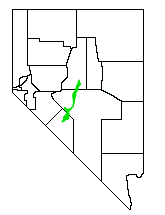
Big Smoky Valley
Encyclopedia

Tonopah Basin
The Tonopah Basin is one of the Central Nevada Desert Basins that extends from the band of arid footslopes along the north side of the Mojave Desert northward into the Big Smoky Valley and the Railroad Valley...
between the Toiyabe
Toiyabe Range
The Toiyabe Range is a range of mountains in central Nevada in the western United States. It starts in northwestern Nye County north of Tonopah, Nevada and runs approximately 120 miles north-northeast through eastern Lander County, making it the second longest range in the state...
and Toquima
Toquima Range
The Toquima Range is a line of mountains in northwestern Nye County, in central Nevada in the western United States. From Hickson Summit on U.S. Route 50, the range runs for approximately 71 miles to the south-southwest. To its west are Big Smoky Valley, scenic State Route 376, and the large...
mountain range
Mountain range
A mountain range is a single, large mass consisting of a succession of mountains or narrowly spaced mountain ridges, with or without peaks, closely related in position, direction, formation, and age; a component part of a mountain system or of a mountain chain...
s. It is about 100 miles (160 km) in length, and is known by other names (some with different spellings): including Great Smoky Valley, Smokey Valley, Smoky Valley, Wen-A-No-Nu-Fee Valley, and Won-A-No-Nu-Fee Valley. The U.S. Geological Survey
United States Geological Survey
The United States Geological Survey is a scientific agency of the United States government. The scientists of the USGS study the landscape of the United States, its natural resources, and the natural hazards that threaten it. The organization has four major science disciplines, concerning biology,...
usually refers to it as "Big Smoky Valley," but the chamber of commerce
Chamber of commerce
A chamber of commerce is a form of business network, e.g., a local organization of businesses whose goal is to further the interests of businesses. Business owners in towns and cities form these local societies to advocate on behalf of the business community...
in the valley calls itself the Greater Smoky Valley Chamber of Commerce.
Approximately 2,500 people live in the valley, which has seven small communities. There is an open-pit
Open-pit mining
Open-pit mining or opencast mining refers to a method of extracting rock or minerals from the earth by their removal from an open pit or borrow....
gold mine at the southern end of the valley, and local industry includes mining
Mining
Mining is the extraction of valuable minerals or other geological materials from the earth, from an ore body, vein or seam. The term also includes the removal of soil. Materials recovered by mining include base metals, precious metals, iron, uranium, coal, diamonds, limestone, oil shale, rock...
, agriculture
Agriculture
Agriculture is the cultivation of animals, plants, fungi and other life forms for food, fiber, and other products used to sustain life. Agriculture was the key implement in the rise of sedentary human civilization, whereby farming of domesticated species created food surpluses that nurtured the...
, and ranching. The valley traverses three counties: Esmeralda
Esmeralda County, Nevada
Esmeralda County is a county in the west of U.S. state of Nevada. Its county seat is Goldfield. Its 2000 census population was officially 971, making its population density 0.1045 inhabitants/km² , the second-lowest of any county-equivalent outside of Alaska. As of 2010, the population had...
, Nye
Nye County, Nevada
-National protected areas:* Ash Meadows National Wildlife Refuge* Death Valley National Park * Humboldt-Toiyabe National Forest * Spring Mountains National Recreation Area -Demographics:...
, and Lander
Lander County, Nevada
Lander County is a county located in the U.S. state of Nevada. As of the 2000 census, the population was 5,794. Its county seat is Battle Mountain.-History:...
. Average yearly precipitation in most of the valley is less than 10 inches. The North and South Twin Rivers flow into the Railroad Valley
Railroad Valley
Railroad Valley is one of the Central Nevada Desert Basins in the Tonopah Basin and is ~80 miles long north-south and up to 20 miles wide, with some southern areas running southwest to northeast. The southern end of the valley begins near Gray Top Mountain and stretches north all the way to...
(the later at 1951 m (6,400.9 ft) elevation, and it is completely diverted except during periods of high flow).http://pubs.usgs.gov/circ/circ1173/circ1173d/chapter07.html

