
Bobonaro
Encyclopedia
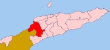
The Bobonaro district is one of 13 administrative districts
within the Democratic Republic of Timor-Leste commonly known as East Timor
. It is the second-most western district on the east half of the island. It has a population of 82,385 (Census 2004) and an area of 1,368 km2. Its subdistricts are Atabae
, Balibó
, Bobonaro
, Cailaco
, Lolotoi (also spelled Lolotoe) and Maliana
. In Portuguese Timor
, the district was the same; however its capital was at Vila Armindo Monteiro, which is now called Bobonaro.
The Savu Sea
lies to the north of Bobonaro. The district borders the districts of Liquiçá to the northeast, Ermera to the east, Ainaro to the southeast, and Cova-Lima
to the south. To the west lies the Indonesia
n province Nusa Tenggara Timur.
The capital of Bobonaro is East Timor's fourth largest city, Maliana
. it has a population of 13,200. It sits at 9.00°S and 125.22°E, 149 km from to the southwest of the national capital, Dili
. The next two largest cities in the district are Bobonaro City (also known as Aubá), with 6,700 people; and Lolotoi with a population of 3,800. Another village is Atabae
in Atabae subdistrict.
Mota'ain
, East Timor's main road border crossing into Indonesia
's West Timor, is located in this district.
The district had been a popular destination in Timor, due to its mountains and hot springs, but it suffered much violence in the war for independence
. Balibó
, located about 10 miles from the Indonesian border, was estimated by Human Rights Watch to be 70% destroyed during the militia violence that preceded the referendum for East Timorese independence. It was also the site of the killing of five Australian-based journalists (the Balibo Five
) by Indonesian forces on October 16, 1975 during an incursion by Indonesia into what was then Portuguese Timor
.
In addition to the official languages of Tetum and Portuguese
, a large part of Bobonaro speaks the Malayo-Polynesian languages
Bunak
and Kemak
, which are designated "national languages" by the constitution.
Districts of East Timor
||East Timor is divided into thirteen administrative districts. The districts are divided into subdistricts, and further subdivided into sucos.The borders between Cova-Lima and Ainaro and between Baucau and Viqueque were changed in 2003.-References:...
within the Democratic Republic of Timor-Leste commonly known as East Timor
East Timor
The Democratic Republic of Timor-Leste, commonly known as East Timor , is a state in Southeast Asia. It comprises the eastern half of the island of Timor, the nearby islands of Atauro and Jaco, and Oecusse, an exclave on the northwestern side of the island, within Indonesian West Timor...
. It is the second-most western district on the east half of the island. It has a population of 82,385 (Census 2004) and an area of 1,368 km2. Its subdistricts are Atabae
Atabae (subdistrict)
Atabae is a subdistrict and suco in the Bobonaro District of East Timor. Its population at the 2010 census was 10,976. The capital of the subdistrict is Aidabaleten, which is sometimes wrongly named Atabae, too....
, Balibó
Balibo
Balibo is a town in East Timor situated approximately from the Indonesian border. It is located in the subdistrict of Balibo, Bobonaro District....
, Bobonaro
Bobonaro
The Bobonaro district is one of 13 administrative districts within the Democratic Republic of Timor-Leste commonly known as East Timor. It is the second-most western district on the east half of the island. It has a population of 82,385 and an area of 1,368 km2. Its subdistricts are Atabae,...
, Cailaco
Cailaco
Cailaco is a town and subdistrict in the Bobonaro District of East Timor. Its population at the 2004 census was 8,374.-Reference:*...
, Lolotoi (also spelled Lolotoe) and Maliana
Maliana
Maliana is a city in East Timor, 149 km southwest of Dili, the national capital. It has a population of 22,000. It is the capital of the district of Bobonaro and subdistrict of Maliana, and is located just a few kilometers from the border with Indonesia...
. In Portuguese Timor
Portuguese Timor
Portuguese Timor was the name of East Timor when it was under Portuguese control. During this period, Portugal shared the island of Timor with the Netherlands East Indies, and later with Indonesia....
, the district was the same; however its capital was at Vila Armindo Monteiro, which is now called Bobonaro.
The Savu Sea
Savu Sea
The Savu Sea is a small sea within Indonesia named for the island of Savu on its southern boundary. It is bounded by Savu and Rai Jua to the south, the islands of Rote and Timor to the east, Flores and the Alor archipelago to the north/northwest, and the island of Sumba to the west/northwest...
lies to the north of Bobonaro. The district borders the districts of Liquiçá to the northeast, Ermera to the east, Ainaro to the southeast, and Cova-Lima
Cova-Lima
Cova Lima is a district of East Timor, in the Southwest part of the country. It has a population of 55,941 and an area of 1,226 km2. The capital of the district is Suai, which lies 136 km from Dili, the national capital...
to the south. To the west lies the Indonesia
Indonesia
Indonesia , officially the Republic of Indonesia , is a country in Southeast Asia and Oceania. Indonesia is an archipelago comprising approximately 13,000 islands. It has 33 provinces with over 238 million people, and is the world's fourth most populous country. Indonesia is a republic, with an...
n province Nusa Tenggara Timur.
The capital of Bobonaro is East Timor's fourth largest city, Maliana
Maliana
Maliana is a city in East Timor, 149 km southwest of Dili, the national capital. It has a population of 22,000. It is the capital of the district of Bobonaro and subdistrict of Maliana, and is located just a few kilometers from the border with Indonesia...
. it has a population of 13,200. It sits at 9.00°S and 125.22°E, 149 km from to the southwest of the national capital, Dili
Dili
Dili, spelled Díli in Portuguese, is the capital, largest city, chief port and commercial centre of East Timor.-Geography and Administration:Dili lies on the northern coast of Timor island, the easternmost of the Lesser Sunda Islands....
. The next two largest cities in the district are Bobonaro City (also known as Aubá), with 6,700 people; and Lolotoi with a population of 3,800. Another village is Atabae
Atabae
Atabae is a city in the suco of Rairobo ....
in Atabae subdistrict.
Mota'ain
Mota'ain
Mota'ain, also spelled Mota'in or Mota Ain, is a village in Bobonaro District in East Timor and is the country's main road border crossing into West Timor in Indonesia...
, East Timor's main road border crossing into Indonesia
Indonesia
Indonesia , officially the Republic of Indonesia , is a country in Southeast Asia and Oceania. Indonesia is an archipelago comprising approximately 13,000 islands. It has 33 provinces with over 238 million people, and is the world's fourth most populous country. Indonesia is a republic, with an...
's West Timor, is located in this district.
The district had been a popular destination in Timor, due to its mountains and hot springs, but it suffered much violence in the war for independence
History of East Timor
East Timor is a small country in Southeast Asia, officially known as Democratic Republic of Timor-Leste. The country comprises the eastern half of the island of Timor and the nearby islands of Atauro and Jaco. The first inhabitants are thought to be descendant of Australoid and Melanesian peoples...
. Balibó
Balibo
Balibo is a town in East Timor situated approximately from the Indonesian border. It is located in the subdistrict of Balibo, Bobonaro District....
, located about 10 miles from the Indonesian border, was estimated by Human Rights Watch to be 70% destroyed during the militia violence that preceded the referendum for East Timorese independence. It was also the site of the killing of five Australian-based journalists (the Balibo Five
Balibo Five
The Balibo Five was a group of journalists for Australian television networks based in the town of Balibo in East Timor where they were killed on 16 October 1975 during Indonesian incursions prior to the invasion....
) by Indonesian forces on October 16, 1975 during an incursion by Indonesia into what was then Portuguese Timor
Portuguese Timor
Portuguese Timor was the name of East Timor when it was under Portuguese control. During this period, Portugal shared the island of Timor with the Netherlands East Indies, and later with Indonesia....
.
In addition to the official languages of Tetum and Portuguese
Portuguese language
Portuguese is a Romance language that arose in the medieval Kingdom of Galicia, nowadays Galicia and Northern Portugal. The southern part of the Kingdom of Galicia became independent as the County of Portugal in 1095...
, a large part of Bobonaro speaks the Malayo-Polynesian languages
Malayo-Polynesian languages
The Malayo-Polynesian languages are a subgroup of the Austronesian languages, with approximately 385.5 million speakers. These are widely dispersed throughout the island nations of Southeast Asia and the Pacific Ocean, with a smaller number in continental Asia...
Bunak
Bunak
The Bunak are an ethnic group that live in the mountainous region of central Timor, split between the political boundary between West Timor, Indonesia, particularly in Lamaknen District and East Timor...
and Kemak
Kemak language
Kemak is a language spoken in East Timor. An alternate name is Ema. It is most closely related to Tocodede and Mambai. It has the status of one of the national languages in the East Timor constitution, besides the official languages of Portuguese and Tetum. The number of speakers has fallen in...
, which are designated "national languages" by the constitution.