Broch
Encyclopedia
British Iron Age
The British Iron Age is a conventional name used in the archaeology of Great Britain, referring to the prehistoric and protohistoric phases of the Iron-Age culture of the main island and the smaller islands, typically excluding prehistoric Ireland, and which had an independent Iron Age culture of...
drystone hollow-walled structure of a type found only in Scotland
Scotland
Scotland is a country that is part of the United Kingdom. Occupying the northern third of the island of Great Britain, it shares a border with England to the south and is bounded by the North Sea to the east, the Atlantic Ocean to the north and west, and the North Channel and Irish Sea to the...
. Brochs include some of the most sophisticated examples of drystone architecture ever created, and belong to the classification "complex Atlantic Roundhouse
Atlantic roundhouse
In archaeology, an Atlantic roundhouse is an Iron Age stone building found in the northern and western parts of mainland Scotland, the Northern Isles and the Hebrides.-Types of structure:...
" devised by Scottish archaeologists in the 1980s. Their origin is a matter of some controversy. The theory that they were defensive military structures is not accepted by many modern archaeologists (see the 'general references' below), while the alternative notion that they were farmhouses is dismissed by some others. Although most stand alone in the landscape, some examples exist of brochs surrounded by clusters of smaller dwellings. There is controversy about whether or not brochs were roofed.
Origin and definition
The word broch is derived from Lowland Scots 'brough', meaning (among other things) fort. In the mid-19th century Scottish antiquaries called brochs 'burgs', after Old NorseOld Norse
Old Norse is a North Germanic language that was spoken by inhabitants of Scandinavia and inhabitants of their overseas settlements during the Viking Age, until about 1300....
borg, with the same meaning. Place names in Scandinavian Scotland such as Burgawater and Burgan show that O.N. borg is the older word used for these structures in the north. Brochs are often referred to as 'duns' in the west. The antiquaries began to use the spelling 'broch' in the 1870s.
A precise definition for the word has proven to be elusive. Brochs are the most spectacular of a complex class of roundhouse buildings found throughout "Atlantic Scotland". The Shetland Amenity Trust lists about 120 sites in Shetland as candidate brochs, while The Royal Commission on the Ancient and Historic Monuments of Scotland identifies a total of 571 candidate broch sites throughout the country. Researcher Euan MacKie has proposed a much smaller total for Scotland of 104.
The origin of brochs is a subject of continuing research. Sixty years ago most archaeologists believed that brochs, usually regarded as castles, were built by immigrants who had been displaced and pushed northward first by the intrusions of Belgic tribes into what is now south-east England towards the end of the second century BC, and later by the Roman invasion
Scotland during the Roman Empire
Scotland during the Roman Empire encompasses a period of protohistory from the arrival of Roman legions in c. AD 71 to their departure in 213. The history of the period is complex: the Roman empire influenced every part of Scotland during the period, however the occupation was neither complete nor...
of southern Britain from AD 43 onwards. Yet there is now little doubt that the hollow-walled broch tower was purely an invention from what is now modern Scotland, or that even the kinds of pottery found within them that most resembled south Britain styles were local hybrid forms. The first of the modern review articles on the subject (MacKie 1965) did not, as is commonly believed, propose that brochs were built by immigrants, but rather that a hybrid culture of a small number of immigrants with the native population of the Hebrides produced them in the first century BC, basing them on earlier, simpler promontory forts. This view contrasted for example with that of Sir Lindsay Scott, who argued—following Childe (1935)—for a wholesale migration into Atlantic Scotland of people from south-west England.
MacKie's theory has fallen from favour too, mainly because from the 1970s there was a general move away from 'diffusionist' explanations in archaeology towards those involving exclusively indigenous development. Meanwhile, the increasing number (albeit still pitifully few) of radiocarbon dates for the primary use of brochs (as opposed to their later, secondary use) still suggests that most of the towers were built in the 1st centuries BC and AD. A few such dates may be earlier, notably the one proposed for Old Scatness Broch in Shetland, where a sheep bone dating to 390–200 BC has been reported The other broch claimed to be substantially older than the 1st century BC is Crosskirk in Caithness but a recent review of the evidence suggests that it cannot plausibly be assigned a date earlier than the 1st centuries BC/AD
Distribution
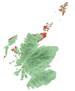
Caithness
Caithness is a registration county, lieutenancy area and historic local government area of Scotland. The name was used also for the earldom of Caithness and the Caithness constituency of the Parliament of the United Kingdom . Boundaries are not identical in all contexts, but the Caithness area is...
, Sutherland
Sutherland
Sutherland is a registration county, lieutenancy area and historic administrative county of Scotland. It is now within the Highland local government area. In Gaelic the area is referred to according to its traditional areas: Dùthaich 'IcAoidh , Asainte , and Cataibh...
and the Northern Isles
Northern Isles
The Northern Isles is a chain of islands off the north coast of mainland Scotland. The climate is cool and temperate and much influenced by the surrounding seas. There are two main island groups: Shetland and Orkney...
have the densest concentrations, but there are also a great many examples in the west of Scotland and the Hebrides
Hebrides
The Hebrides comprise a widespread and diverse archipelago off the west coast of Scotland. There are two main groups: the Inner and Outer Hebrides. These islands have a long history of occupation dating back to the Mesolithic and the culture of the residents has been affected by the successive...
.
Although mainly concentrated in the northern Highlands and the Islands, a few examples occur in the Borders
Scottish Borders
The Scottish Borders is one of 32 local government council areas of Scotland. It is bordered by Dumfries and Galloway in the west, South Lanarkshire and West Lothian in the north west, City of Edinburgh, East Lothian, Midlothian to the north; and the non-metropolitan counties of Northumberland...
(for example Edin's Hall Broch
Edin's Hall Broch
Edin's Hall Broch is a 2nd century broch near Duns in the Borders of Scotland. It is one of very few brochs found in southern Scotland. It is roughly 27m in diameter.-External links:...
), on the west coast of Dumfries and Galloway
Dumfries and Galloway
Dumfries and Galloway is one of 32 unitary council areas of Scotland. It was one of the nine administrative 'regions' of mainland Scotland created in 1975 by the Local Government etc. Act 1973...
and near Stirling
Stirling
Stirling is a city and former ancient burgh in Scotland, and is at the heart of the wider Stirling council area. The city is clustered around a large fortress and medieval old-town beside the River Forth...
. This small group of southern brochs has never been satisfactorily explained.
Purposes
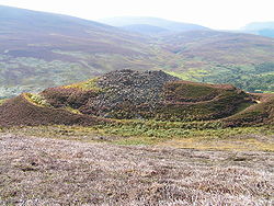
From the 1930s to the 1960s, archaeologists like V. Gordon Childe and later John Hamilton regarded them as castles where local landowners held sway over a subject population.
The castle theory fell from favour among Scottish archaeologists in the 1980s, due to a lack of supporting archaeological evidence. These archaeologists suggested that defensibility was never a major concern in the siting of a broch, and argued that they may have been the "stately home
Stately home
A stately home is a "great country house". It is thus a palatial great house or in some cases an updated castle, located in the British Isles, mostly built between the mid-16th century and the early part of the 20th century, as well as converted abbeys and other church property...
s" of their time, objects of prestige and very visible demonstrations of superiority for important families (Armit 2003). Once again, however, there is a lack of archaeological proof for this reconstruction, and the sheer number of brochs, sometimes in places with a lack of good land, makes it problematical.
Brochs' close groupings and profusion in many areas may indeed suggest that they had a primarily defensive or even offensive function. Some of them were sited beside precipitous cliffs and were protected by large ramparts, artificial or natural: a good example is at Burland near Gulberwick in Shetland, on a clifftop and cut off from the mainland by huge ditches. Often they are at key strategic points. In Shetland they sometimes cluster on each side of narrow stretches of water: the broch of Mousa
Mousa
Mousa is a small island in Shetland, Scotland, uninhabited since the nineteenth century. The island is known for the Broch of Mousa, an Iron Age round tower, and is designated as a Special Protection Area for storm-petrel breeding colonies.-Geography:...
, for instance, is directly opposite another at Burraland in Sandwick. In Orkney there are more than a dozen on the facing shores of Eynhallow Sound, and many at the exits and entrances of the great harbour of Scapa Flow
Scapa Flow
right|thumb|Scapa Flow viewed from its eastern endScapa Flow is a body of water in the Orkney Islands, Scotland, United Kingdom, sheltered by the islands of Mainland, Graemsay, Burray, South Ronaldsay and Hoy. It is about...
. In Sutherland
Sutherland
Sutherland is a registration county, lieutenancy area and historic administrative county of Scotland. It is now within the Highland local government area. In Gaelic the area is referred to according to its traditional areas: Dùthaich 'IcAoidh , Asainte , and Cataibh...
quite a few are placed along the sides and at the mouths of deep valleys. Writing in 1956 John Stewart suggested that brochs were forts put up by a military society to scan and protect the countryside and seas.
Finally, some archaeologists consider broch sites individually, doubting that there ever was a single common purpose for which every broch was constructed. There are differences between the various areas in which brochs are found, with regard to position, dimensions and likely status. For example, the broch 'villages' which occur at a few places in Orkney have no parallel in the Western Isles.
Structures
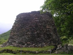
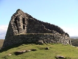
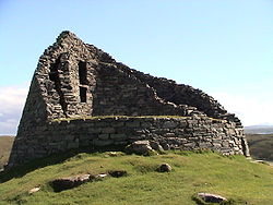
Brochs vary from 5 to 15 metres (16–50 ft) in internal diameter, with 3 metre (10 ft) thick walls. On average, the walls only survive to a few metres. There are five extant examples of towers with significantly higher walls: Dun Carloway on LewisLewis
Lewis is the northern part of Lewis and Harris, the largest island of the Western Isles or Outer Hebrides of Scotland. The total area of Lewis is ....
, Dun Telve and Dun Troddan in Glenelg
Glenelg, Scotland
-Geography:Glenelg is located by the Kyle Rhea narrows, where Skye is closest to the mainland. Road access is by the 339m Bealach Ratagain from Shiel Bridge, on the main Inverness to Skye road....
, Mousa in Shetland and Dun Dornaigil
Dun Dornaigil
Dun Dornaigil is an Iron Age broch in Sutherland in the Scottish Highlands. It is located at next to the Strathmore River, south of Ben Hope, immediately adjacent to the single track A836 road...
in Sutherland, all of whose walls exceed 6.5 m (21 ft) in height. Mousa's walls are the best preserved and are still 13 m tall, however it is not clear how many brochs originally stood this high. A frequent characteristic is that the walls are galleried (the outer and inner wall skins are separate but tied together with linking stone slabs, with an open space between). These linking slabs may in some cases have served as steps to higher floors. Beside the door, it is normal for there to be a cell breaking off from the passage; this is known as the guard cell. It has been found in some Shetland brochs that guard cells in entrance passageways are close to large door-check stones. Though there was much argument in the past, it is now generally accepted that brochs were roofed, probably with a conical timber framed roof covered with a locally sourced thatch. The evidence for this assertion is still fairly scanty, though excavations at Dun Bharabhat, Lewis, have supported it. The main difficulty with this interpretation continues to be the potential source of structural timber, though bog and driftwood may have been plentiful sources.
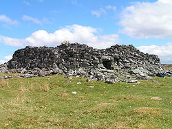
Culswick
Culswick Broch is an unexcavated coastal broch in the Shetland Islands of Scotland at . Built of striking red stone, it has beautiful views all around, including Foula and Vaila isles, and Fitful Head and Fair Isle in the south. The broch stands commandingly on the top of a massive rock platform...
in Shetland have unusual triangular lintels above the entrance door.
As in the case of Old Scatness
Old Scatness
Old Scatness is an archeological site in the South Mainland of Shetland, near Sumburgh Airport consisting of mediaeval, Viking, Pictish, and Bronze Age remains. It has been a settlement for thousands of years, each new generation adding buildings, and leveling off old ones...
in Shetland (near Jarlshof
Jarlshof
Jarlshof is the best known prehistoric archaeological site in Shetland, Scotland. It lies near the southern tip of the Shetland Mainland and has been described as "one of the most remarkable archaeological sites ever excavated in the British Isles"...
and Burroughston
Burroughston Broch
Burroughston Broch is an Iron Age archaeological site on the island of Shapinsay within the Orkney Islands of Scotland. The site overlooks the North Sea on the northeast part of Shapinsay. Slightly to the south lies Linton Bay. Excavated in the mid 19th century, Burroughston Broch has its earth...
on Shapinsay
Shapinsay
Shapinsay is one of the Orkney Islands off the north coast of mainland Scotland. There is one village on the island, Balfour, from which roll-on/roll-off car ferries sail to Kirkwall on the Orkney Mainland...
, brochs were sometimes located close to arable land
Arable land
In geography and agriculture, arable land is land that can be used for growing crops. It includes all land under temporary crops , temporary meadows for mowing or pasture, land under market and kitchen gardens and land temporarily fallow...
and a source of water
Water supply
Water supply is the provision of water by public utilities, commercial organisations, community endeavours or by individuals, usually via a system of pumps and pipes...
(some have wells or natural springs rising within their central space). Sometimes, on the other hand, they were sited in wilderness areas (e.g. Levenwick
Levenwick
Levenwick is a very scenic small village about south of Lerwick, on the east side of the South Mainland of Shetland. It is part of the parish of Dunrossness and the Levenwick Health Centre provides medical support for the Dunrossness area....
and Culswick
Culswick
Culswick Broch is an unexcavated coastal broch in the Shetland Islands of Scotland at . Built of striking red stone, it has beautiful views all around, including Foula and Vaila isles, and Fitful Head and Fair Isle in the south. The broch stands commandingly on the top of a massive rock platform...
in Shetland, Castle Cole in Sutherland
Sutherland
Sutherland is a registration county, lieutenancy area and historic administrative county of Scotland. It is now within the Highland local government area. In Gaelic the area is referred to according to its traditional areas: Dùthaich 'IcAoidh , Asainte , and Cataibh...
). Brochs are often built beside the sea (Carn Liath, Sutherland); sometimes they are on islands in lochs (e.g. Clickimin in Shetland).
About 20 Orcadian broch sites include small settlements of stone buildings surrounding the main tower. Examples include Howe, near Stromness
Stromness
Stromness is the second-biggest town in Orkney, Scotland. It is in the south-west of Mainland Orkney. It is also a parish, with the town of Stromness as its capital.-Etymology:...
, Gurness Broch in the north west of Mainland, Orkney, Midhowe on Rousay
Rousay
Rousay is a small, hilly island about north of Orkney's Mainland, off the north coast of Scotland, and has been nicknamed "the Egypt of the north", due to its tremendous archaeological diversity and importance....
and Lingro near Kirkwall
Kirkwall
Kirkwall is the biggest town and capital of Orkney, off the coast of northern mainland Scotland. The town is first mentioned in Orkneyinga saga in the year 1046 when it is recorded as the residence of Rögnvald Brusason the Earl of Orkney, who was killed by his uncle Thorfinn the Mighty...
(destroyed in the 1980s). There are "broch village" sites in Caithness, but elsewhere they are unknown.
Most brochs are unexcavated Many of those that have been properly examined show that they continued in use for many centuries, although the interiors were often modified and changed, and they underwent many phases of habitation and abandonment. The end of the broch period par excellence seems to have come around AD 200-300.
