
Byam Martin Mountains
Encyclopedia
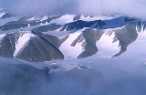
The Byam Martin Mountains are a rugged mountain range
extending east to west across Bylot Island
, Nunavut
, Canada
. It is one of the most northern ranges in the world and is an extension of the Baffin Mountains
which in turn form part of the Arctic Cordillera
mountain system. The highest mountain in the range is Angilaaq Mountain
, 1951 m (6,401 ft), located near the island's center. Sharp peaks and ridge
s, divided by deep glacier-filled valley
s are typical features in the range and has been extensively modified by glacial erosion
. The Byam Martin Mountains have not been conducive to habitation. While there are no permanent settlements in the Byam Martin Mountains, Inuit
from Pond Inlet
and elsewhere regularly travel to the range.
The Byam Martin Mountains are made up of Archean
-Aphebian igneous
crystal
line rock and Proterozoic
metasedimentary and metamorphic rock
, such as gneiss
.
Mountain range
A mountain range is a single, large mass consisting of a succession of mountains or narrowly spaced mountain ridges, with or without peaks, closely related in position, direction, formation, and age; a component part of a mountain system or of a mountain chain...
extending east to west across Bylot Island
Bylot Island
Bylot Island lies off the northern end of Baffin Island in Nunavut Territory, Canada. At it is ranked 71st largest island in the world and Canada's 17th largest island. It is also one of the largest uninhabited islands in the world. While there are no permanent settlements on this Canadian Arctic...
, Nunavut
Nunavut
Nunavut is the largest and newest federal territory of Canada; it was separated officially from the Northwest Territories on April 1, 1999, via the Nunavut Act and the Nunavut Land Claims Agreement Act, though the actual boundaries had been established in 1993...
, Canada
Canada
Canada is a North American country consisting of ten provinces and three territories. Located in the northern part of the continent, it extends from the Atlantic Ocean in the east to the Pacific Ocean in the west, and northward into the Arctic Ocean...
. It is one of the most northern ranges in the world and is an extension of the Baffin Mountains
Baffin Mountains
The Baffin Mountains are a mountain range running along the northeastern coast of Baffin Island and Bylot Island, Nunavut are part of the Arctic Cordillera. The ice-capped mountains are some of the highest peaks of eastern North America, reaching a height of above sea level...
which in turn form part of the Arctic Cordillera
Arctic Cordillera
The Arctic Cordillera is a vast, deeply dissected chain of mountain ranges extending along the northeastern flank of the Canadian Arctic Archipelago from Ellesmere Island to the northeasternmost part of the Labrador Peninsula in northern Labrador and northern Quebec, Canada...
mountain system. The highest mountain in the range is Angilaaq Mountain
Angilaaq Mountain
Angilaaq Mountain is a mountain in Qikiqtaaluk Region, Nunavut, Canada. It is located north of Pond Inlet. It is the highest mountain on Bylot Island and lies in the Byam Martin Mountains, which is a northern extension of the Baffin Mountains....
, 1951 m (6,401 ft), located near the island's center. Sharp peaks and ridge
Ridge
A ridge is a geological feature consisting of a chain of mountains or hills that form a continuous elevated crest for some distance. Ridges are usually termed hills or mountains as well, depending on size. There are several main types of ridges:...
s, divided by deep glacier-filled valley
Valley
In geology, a valley or dale is a depression with predominant extent in one direction. A very deep river valley may be called a canyon or gorge.The terms U-shaped and V-shaped are descriptive terms of geography to characterize the form of valleys...
s are typical features in the range and has been extensively modified by glacial erosion
Erosion
Erosion is when materials are removed from the surface and changed into something else. It only works by hydraulic actions and transport of solids in the natural environment, and leads to the deposition of these materials elsewhere...
. The Byam Martin Mountains have not been conducive to habitation. While there are no permanent settlements in the Byam Martin Mountains, Inuit
Inuit
The Inuit are a group of culturally similar indigenous peoples inhabiting the Arctic regions of Canada , Denmark , Russia and the United States . Inuit means “the people” in the Inuktitut language...
from Pond Inlet
Pond Inlet, Nunavut
Pond Inlet is a small, predominantly Inuit community in the Qikiqtaaluk Region of Nunavut, Canada and is located at the top of Baffin Island. As of the 2006 census the population was 1,315, an increase of 7.8% from the 2001 census making it the largest of the four hamlets above the 72nd parallel...
and elsewhere regularly travel to the range.
The Byam Martin Mountains are made up of Archean
Archean
The Archean , also spelled Archeozoic or Archæozoic) is a geologic eon before the Paleoproterozoic Era of the Proterozoic Eon, before 2.5 Ga ago. Instead of being based on stratigraphy, this date is defined chronometrically...
-Aphebian igneous
Igneous rock
Igneous rock is one of the three main rock types, the others being sedimentary and metamorphic rock. Igneous rock is formed through the cooling and solidification of magma or lava...
crystal
Crystal
A crystal or crystalline solid is a solid material whose constituent atoms, molecules, or ions are arranged in an orderly repeating pattern extending in all three spatial dimensions. The scientific study of crystals and crystal formation is known as crystallography...
line rock and Proterozoic
Proterozoic
The Proterozoic is a geological eon representing a period before the first abundant complex life on Earth. The name Proterozoic comes from the Greek "earlier life"...
metasedimentary and metamorphic rock
Metamorphic rock
Metamorphic rock is the transformation of an existing rock type, the protolith, in a process called metamorphism, which means "change in form". The protolith is subjected to heat and pressure causing profound physical and/or chemical change...
, such as gneiss
Gneiss
Gneiss is a common and widely distributed type of rock formed by high-grade regional metamorphic processes from pre-existing formations that were originally either igneous or sedimentary rocks.-Etymology:...
.