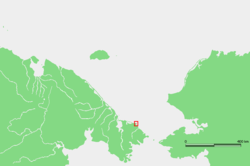
Cape Serdtse-Kamen
Encyclopedia

Headland
A headland is a point of land, usually high and often with a sheer drop, that extends out into a body of water.Headland can also refer to:*Headlands and bays*headLand, an Australian television series...
on the northeastern coast of Chukotka
Chukotka Autonomous Okrug
Chukotka Autonomous Okrug , or Chukotka , is a federal subject of Russia located in the Russian Far East.Chukotka has a population of 53,824 according to the 2002 Census, and a surface area of . The principal town and the administrative center is Anadyr...
, Russian Federation. It is about 140 Km west of Cape Dezhnev
Cape Dezhnev
Cape Dezhnyov or Cape Dezhnev is a cape that forms the eastmost mainland point of Eurasia. It is located on the Chukchi Peninsula in the very thinly populated Chukotka Autonomous Okrug of Russia. This cape is located between the Bering Sea and the Chukchi Sea, across from Cape Prince of Wales in...
, 120 Km east of Kolyuchinskaya Bay
Kolyuchinskaya Bay
Kolyuchinskaya Bay is a large bay in the Chukchi Sea on the northern shore of the Chukotka Peninsula, Russia. To the west is Cape Vankarem and to the east Neskynpil'gyn Lagoon and Cape Serdtse-Kamen. The length of the bay is 100 km. Its mouth is only 2.8 km because of the Serykh Gusey...
and about 30 km to the east of the Neskynpil'gyn Lagoon
Neskynpil'gyn Lagoon
The Neskynpil'gyn Lagoon is a shallow coastal lake in the Chukchi Sea at the northern shore of the Chukotka Peninsula, Russia. 30 km to the east is Kolyuchinskaya Bay and 25 km west, Cape Serdtse-Kamen....
. Nearby is the village of Enurmino
Enurmino
Enurmino ) is a rural locality in Chukotsky District of Chukotka Autonomous Okrug, Russia. It is located on the Chukchi Sea near Cape Serdtse-Kamen. The population of the village as of March 2003 was 297, of which 296 were indigenous peoples...
.
Cape Serdtse-Kamen is a geographic landmark, east of which the Chukchi Sea
Chukchi Sea
Chukchi Sea is a marginal sea of the Arctic Ocean. It is bounded on the west by the De Long Strait, off Wrangel Island, and in the east by Point Barrow, Alaska, beyond which lies the Beaufort Sea. The Bering Strait forms its southernmost limit and connects it to the Bering Sea and the Pacific...
coast slants sharply to the south-east until the Bering Strait
Bering Strait
The Bering Strait , known to natives as Imakpik, is a sea strait between Cape Dezhnev, Chukotka Autonomous Okrug, Russia, the easternmost point of the Asian continent and Cape Prince of Wales, Alaska, USA, the westernmost point of the North American continent, with latitude of about 65°40'N,...
.
The wreck of the Soviet steamer Chelyuskin
Chelyuskin steamship
SS Chelyuskin was a Soviet steamship reinforced to navigate through polar ice that became ice-bound in Arctic waters during navigation along the Northern Maritime Route from Murmansk to Vladivostok...
, which sank in 1934 during its pioneer exploration of the Northern Sea Route
Northern Sea Route
The Northern Sea Route is a shipping lane officially defined by Russian legislation from the Atlantic Ocean to the Pacific Ocean specifically running along the Russian Arctic coast from Murmansk on the Barents Sea, along Siberia, to the Bering Strait and Far East. The entire route lies in Arctic...
, was discovered in 2006 on the seabed at the depth of about 50 m not far from the cape. The village of Uelen
Uelen
Uelen is a rural locality in the Chukotsky District, just south of the Arctic Circle in Chukotka Autonomous Okrug in the Russian Far East. Population: 776 in 2003, with 595 Chukchi and 72 Yupik. Located near Cape Dezhnev where the Bering Sea meets the Chukchi Sea, it is the easternmost settlement...
, the easternmost settlement in Russia
Extreme points of Russia
This is a list of the extreme points and extreme elevations in Russia.The northernmost and easternmost points of Russia coincide with those of Eurasia ....
, is located 150 km to the southeast of Cape Serdtse-Kamen along the coastline.
Ecology
The area around this landhead is a natural habitat for the Short-tailed AlbatrossShort-tailed Albatross
The Short-tailed Albatross or Steller's Albatross, Phoebastria albatrus, is a large rare seabird from the North Pacific. Although related to the other North Pacific albatrosses, it also exhibits behavioural and morphological links to the albatrosses of the Southern Ocean...
(Phoebastria albatrus).
Bowhead whales are frequently sighted in the waters off the Serdtse-Kamen Cape. Very large numbers of walruses have been observed resting on shore and in the shallow waters adjacent to this cape during the late autumn.

