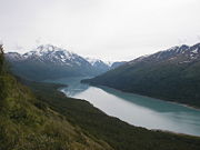
Chugach State Park
Encyclopedia

State park
State parks are parks or other protected areas managed at the federated state level within those nations which use "state" as a political subdivision. State parks are typically established by a state to preserve a location on account of its natural beauty, historic interest, or recreational...
in the Municipality of Anchorage
Anchorage, Alaska
Anchorage is a unified home rule municipality in the southcentral part of the U.S. state of Alaska. It is the northernmost major city in the United States...
in the U.S. state
U.S. state
A U.S. state is any one of the 50 federated states of the United States of America that share sovereignty with the federal government. Because of this shared sovereignty, an American is a citizen both of the federal entity and of his or her state of domicile. Four states use the official title of...
of Alaska
Alaska
Alaska is the largest state in the United States by area. It is situated in the northwest extremity of the North American continent, with Canada to the east, the Arctic Ocean to the north, and the Pacific Ocean to the west and south, with Russia further west across the Bering Strait...
. Located in the Chugach Mountains
Chugach Mountains
The Chugach Mountains of southern Alaska are the northernmost of the several mountain ranges that make up the Pacific Coast Ranges of the western edge of North America. The range is about 500 km long, running generally east-west. Its highest point is Mount Marcus Baker, at , but most of its...
just east of the Anchorage Bowl, it is a very popular recreation destination. It is the third-largest state park in the United States.
Chugach State Park is accessible through numerous trailheads all located along the east side of Anchorage, or the southern side of Eagle River. The Chugach State Park website lists 28 recognized trailheads. The Park has three public campgrounds, located at Eklutna Lake, Eagle River, and Bird Creek. The campgrounds are manned by a host who collects the small fee. Amenities include fire rings, picnic tables, water, and latrines. The Park also has interpretive and Alaskan information available at the Eagle River Nature Center, which is operated by a non-profit organization in cooperation with the State Park.
The Seward Highway
Seward Highway
The Seward Highway is a highway in the U.S. state of Alaska that extends 127 miles from Seward to Anchorage. It was completed in 1951 and runs through the scenic Kenai Peninsula and Turnagain Arm, for which it was designated an All-American Road by the U.S...
, from Anchorage to Seward
Seward, Alaska
Seward is a city in Kenai Peninsula Borough in the U.S. state of Alaska. According to 2005 Census Bureau estimates, the population of the city is 3,016....
, follows part of the southern edge of the Park along the Turnagain Arm. This stretch of highway is listed as a National Scenic Byway
National Scenic Byway
A National Scenic Byway is a road recognized by the United States Department of Transportation for its archeological, cultural, historic, natural, recreational, and/or scenic qualities. The program was established by Congress in 1991 to preserve and protect the nation's scenic but often...
and is designated as an All-American Road http://www.byways.org/explore/byways/10390/stories/47123.
There are several viewpoints along the Seward Highway. One of the most visited is Beluga Point, Mile 110.5, named for the Beluga whales that frequent the Arm. Another popular viewpoint along the Seward Highway is Windy Corner at Mile 106. It has no facilities except parking, but Dall sheep
Dall Sheep
The Dall sheep , Ovis dalli, is a species of sheep native to northwestern North America, ranging from white to slate brown in color and having curved yellowish brown horns...
just up the hill are worth the stop.
The Park is typically split into three different zones.
The North Park
This section of Chugach State Park is from Eagle River North to the Parks border at Pioneer Peak. This area includes the Eklutna lake area, as well as the Big Peters Creek Trailhead and the Ptarmigan Valley trailhead. Eklutna lake is popular with ATV's and hikers. The Eklutna lake area has the biggest mountains of the park, with Bashful peak coming in at 8,005'.
The Central Park
This area of Park includes Eagle River south to the Canyon Road trailhead on the Anchorage hillside. This area of the park includes many popular trailheads including the Crow Creek Pass trailhead in Eagle River, South Fork of Eagle River trailhead, Basher Road, Upper Huffman, Prospect Heights, Glen Alps, and Canyon Road.
The South Park
This area includes all of the park which borders Turnagain Arm along the Seward Highway. There is the popular Turnagain Arm trail, which runs from Potter Marsh to Windy Corner. There are also hikes in the McHugh Creek area, the Falls Creek trailhead, Bird Ridge, and the Rainbow trailhead. The southern park boundary lies just to the north of the city of Girdwood, where Chugach National Forest begins.

