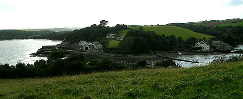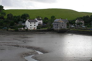
Churchtown Farm
Encyclopedia

Community
The term community has two distinct meanings:*a group of interacting people, possibly living in close proximity, and often refers to a group that shares some common values, and is attributed with social cohesion within a shared geographical location, generally in social units larger than a household...
nature reserve
Nature reserve
A nature reserve is a protected area of importance for wildlife, flora, fauna or features of geological or other special interest, which is reserved and managed for conservation and to provide special opportunities for study or research...
one mile south of Saltash
Saltash
Saltash is a town and civil parish in Cornwall, England, United Kingdom. It has a population of 14,964. It lies in the south east of Cornwall, facing Plymouth over the River Tamar. It was in the Caradon district until March 2009 and is known as "the gateway to Cornwall". Saltash means ash tree by...
, Cornwall
Cornwall
Cornwall is a unitary authority and ceremonial county of England, within the United Kingdom. It is bordered to the north and west by the Celtic Sea, to the south by the English Channel, and to the east by the county of Devon, over the River Tamar. Cornwall has a population of , and covers an area of...
, United Kingdom
United Kingdom
The United Kingdom of Great Britain and Northern IrelandIn the United Kingdom and Dependencies, other languages have been officially recognised as legitimate autochthonous languages under the European Charter for Regional or Minority Languages...
. It is owned and managed by Cornwall Wildlife Trust
Cornwall Wildlife Trust
The Cornwall Wildlife Trust is a charitable organisation founded in 1962 that is concerned solely with Cornwall, United Kingdom.It deals with the conservation and preservation of Cornwall's wildlife and habitats managing over 50 nature reserves covering approximately , amongst them Looe...
, and includes diverse
Diverse
Diverse is an American rapper. An underground hip-hop artist, he has received critical acclaim "from knowledgeable heads worldwide".-Career:...
habitats such as grassland
Grassland
Grasslands are areas where the vegetation is dominated by grasses and other herbaceous plants . However, sedge and rush families can also be found. Grasslands occur naturally on all continents except Antarctica...
, estuarine mudflats, wetland
Wetland
A wetland is an area of land whose soil is saturated with water either permanently or seasonally. Wetlands are categorised by their characteristic vegetation, which is adapted to these unique soil conditions....
, woodland
Woodland
Ecologically, a woodland is a low-density forest forming open habitats with plenty of sunlight and limited shade. Woodlands may support an understory of shrubs and herbaceous plants including grasses. Woodland may form a transition to shrubland under drier conditions or during early stages of...
, disused quarries
Quarry
A quarry is a type of open-pit mine from which rock or minerals are extracted. Quarries are generally used for extracting building materials, such as dimension stone, construction aggregate, riprap, sand, and gravel. They are often collocated with concrete and asphalt plants due to the requirement...
and hedgerows.
Situated within the Tamar Valley AONB, and positioned between the rivers Tamar
River Tamar
The Tamar is a river in South West England, that forms most of the border between Devon and Cornwall . It is one of several British rivers whose ancient name is assumed to be derived from a prehistoric river word apparently meaning "dark flowing" and which it shares with the River Thames.The...
and Lynher
River Lynher
The River Lynher flows through east Cornwall, UK, passing St Germans and enters the River Tamar at the Hamoaze, which in turn flows into Plymouth Sound.-Geography:...
as well as Forder Creek, the majority of the reserve is farmland
Arable land
In geography and agriculture, arable land is land that can be used for growing crops. It includes all land under temporary crops , temporary meadows for mowing or pasture, land under market and kitchen gardens and land temporarily fallow...
. This includes hay
Hay
Hay is grass, legumes or other herbaceous plants that have been cut, dried, and stored for use as animal fodder, particularly for grazing livestock such as cattle, horses, goats, and sheep. Hay is also fed to pets such as rabbits and guinea pigs...
meadows and arable
Arable land
In geography and agriculture, arable land is land that can be used for growing crops. It includes all land under temporary crops , temporary meadows for mowing or pasture, land under market and kitchen gardens and land temporarily fallow...
fields. At 61 hectares, it is the third biggest reserve that the Cornwall Wildlife Trust owns.
The land on the reserve is being farmed in a way which reflects traditional Cornish
Cornwall
Cornwall is a unitary authority and ceremonial county of England, within the United Kingdom. It is bordered to the north and west by the Celtic Sea, to the south by the English Channel, and to the east by the county of Devon, over the River Tamar. Cornwall has a population of , and covers an area of...
farming, benefiting wildlife in many ways. Historically, Churchtown Farm was farmed for dairy
Dairy
A dairy is a business enterprise established for the harvesting of animal milk—mostly from cows or goats, but also from buffalo, sheep, horses or camels —for human consumption. A dairy is typically located on a dedicated dairy farm or section of a multi-purpose farm that is concerned...
and arable production. From the 1960s, most of the fields were intensively managed
Intensive farming
Intensive farming or intensive agriculture is an agricultural production system characterized by the high inputs of capital, labour, or heavy usage of technologies such as pesticides and chemical fertilizers relative to land area....
, being re-seeded with highly productive rye grass mixtures maintained by regular applications of chemical fertilisers and heavy grazing. This intensive management has artificially increased the soil nutrients and encouraged pastures with a very limited range of plant species and little structural variation. In such a field there is little insect, animal or bird life. In an attempt to encourage wildlife back to the farm, Cornwall Wildlife Trust are using a number of less intensive management techniques aimed at reducing the soil nutrient levels and increasing the number of
plant species.

Hornblendite
Hornblendite is a plutonic rock consisting mainly of the amphibole hornblende. Hornblende rich ultramafic rocks are rare and when hornblende is the dominant mineral phase they are classified as hornblendites with qualifiers such as garnet hornblendite identifying a second abundant contained...
was quarried for use in road construction. Both quarries are now County Geological Sites.
Oystercatchers, Dunlin
Dunlin
The Dunlin, Calidris alpina, is a small wader, sometimes separated with the other "stints" in Erolia. It is a circumpolar breeder in Arctic or subarctic regions. Birds that breed in northern Europe and Asia are long-distance migrants, wintering south to Africa, southeast Asia and the Middle East...
s, Egrets, Avocets and Greenshank
Greenshank
The Common Greenshank is a wader in the large family Scolopacidae, the typical waders. Its closest relative is the Greater Yellowlegs, together with which and the Spotted Redshank it forms a close-knit group...
can all be seen on the mudflats.

