
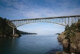
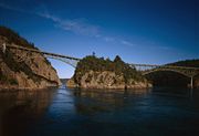
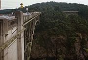
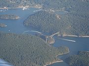
Deception Pass Bridge
Encyclopedia
Whidbey Island
Whidbey Island is one of nine islands located in Island County, Washington, in the United States. Whidbey is located about north of Seattle, and lies between the Olympic Peninsula and the I-5 corridor of western Washington...
to Fidalgo Island
Fidalgo Island
Fidalgo Island is an island in Skagit County, Washington, located about north of Seattle. To the east, it is separated from the mainland by the Swinomish Channel, and from Whidbey Island to the south by Deception Pass...
in the U.S. state of Washington. It was a Washington State Highways project, and included project elements built by young workers from the Civilian Conservation Corps
Civilian Conservation Corps
The Civilian Conservation Corps was a public work relief program that operated from 1933 to 1942 in the United States for unemployed, unmarried men from relief families, ages 18–25. A part of the New Deal of President Franklin D...
. Completion of the bridge was a factor in the decision to build Naval Air Station Whidbey Island
Naval Air Station Whidbey Island
Naval Air Station Whidbey Island is a naval air station located in two sections around Oak Harbor, Washington, USA. It was commissioned as an active U.S. Navy installation on 21 September 1942....
and helped Oak Harbor, Washington
Oak Harbor, Washington
Oak Harbor is a city located on Whidbey Island in Island County, Washington. The population was 22,075 at the 2010 census.Oak Harbor was incorporated on May 14, 1915.-History:Oak Harbor is Whidbey Island's largest incorporated city...
flourish. The bridge is a commonly-photographed landmark of the Puget Sound
Puget Sound
Puget Sound is a sound in the U.S. state of Washington. It is a complex estuarine system of interconnected marine waterways and basins, with one major and one minor connection to the Strait of Juan de Fuca and the Pacific Ocean — Admiralty Inlet being the major connection and...
region.
History
In the spring of 1792, Joseph WhidbeyJoseph Whidbey
Joseph Whidbey was a member of the Royal Navy who served on the Vancouver Expedition 1791–1795, and later achieved renown as a naval engineer. He is notable for having been the first European to discover and chart Admiralty Island in the Alexander Archipelago in 1794.Little is recorded of...
, master of HMS Discovery
HMS Discovery (1789)
HMS Discovery was a Royal Navy ship launched in 1789 and best known as the lead ship in George Vancouver's exploration of the west coast of North America in his famous 1791-1795 expedition. She was converted to a bomb vessel in 1798 and participated in the Battle of Copenhagen. Thereafter she...
and Captain Vancouver's chief navigator proved that it was not really a small bay as charted by the Spaniards (hence the name "Deception"), but a deep and turbulent channel that connects the Strait of Juan de Fuca
Strait of Juan de Fuca
The Strait of Juan de Fuca is a large body of water about long that is the Salish Sea outlet to the Pacific Ocean...
with the Saratoga Passage
Saratoga Passage
Saratoga Passage lies in Puget Sound between Whidbey Island and Camano Island.Saratoga Passage extends about 18 miles in a northwesterly direction from its entrance between Sandy Point on the Whidbey Island side and Camano Head on the other. At its northern end, Saratoga Passage connects with Penn...
, which separates the mainland from what they believed was a peninsula (actually Fidalgo Island and Whidbey Island). Thomas Coupe, a sea captain and founder of Coupeville, was the only man ever to sail a full-rigged ship through the strait discovered by Whidbey.
In the early years of the 20th century, travelers of the horse-and-buggy era used an unscheduled ferry to cross from Fidalgo Island to Whidbey Island. To call the ferry, they banged a saw with a mallet and then sat back to wait.
The bridge, one of the scenic wonders of the Pacific Northwest
Pacific Northwest
The Pacific Northwest is a region in northwestern North America, bounded by the Pacific Ocean to the west and, loosely, by the Rocky Mountains on the east. Definitions of the region vary and there is no commonly agreed upon boundary, even among Pacific Northwesterners. A common concept of the...
, is actually two spans, one over Canoe Pass to the north, and another over Deception Pass to the south. Construction began in August 1934, and the completed bridge was dedicated at noon on July 31, 1935. The Wallace Bridge and Structural Co. of Seattle, Washington
Seattle, Washington
Seattle is the county seat of King County, Washington. With 608,660 residents as of the 2010 Census, Seattle is the largest city in the Northwestern United States. The Seattle metropolitan area of about 3.4 million inhabitants is the 15th largest metropolitan area in the country...
provided 460 tons of steel for the 511-foot Canoe Pass arch and 1130 tons for the 976-foot Deception Pass span. The cost of the New Deal
New Deal
The New Deal was a series of economic programs implemented in the United States between 1933 and 1936. They were passed by the U.S. Congress during the first term of President Franklin D. Roosevelt. The programs were Roosevelt's responses to the Great Depression, and focused on what historians call...
-era construction was $482,000, made possible through the Public Works Administration
Public Works Administration
The Public Works Administration , part of the New Deal of 1933, was a large-scale public works construction agency in the United States headed by Secretary of the Interior Harold L. Ickes. It was created by the National Industrial Recovery Act in June 1933 in response to the Great Depression...
and county funds.
In 1982, the bridge was listed in the National Register of Historic Places
National Register of Historic Places
The National Register of Historic Places is the United States government's official list of districts, sites, buildings, structures, and objects deemed worthy of preservation...
.
It cost more to paint the spans in 1983 than to build them in 1935. They were painted again in 1997.
Bridge Facts
- Height from water to roadway: about 180 feet, depending on the tideTideTides are the rise and fall of sea levels caused by the combined effects of the gravitational forces exerted by the moon and the sun and the rotation of the Earth....
- Roadway: two 11 foot lanes, one in each direction
- Sidewalks: 3 foot sidewalk on each side
- Width of bridge deck: 28 feet
- Total length: 1487 feet (more than a quarter mile)
- Canoe Pass: one 350-ft arch and three concrete T-beam approach spans
- Deception Pass: two 175-ft cantileverCantileverA cantilever is a beam anchored at only one end. The beam carries the load to the support where it is resisted by moment and shear stress. Cantilever construction allows for overhanging structures without external bracing. Cantilevers can also be constructed with trusses or slabs.This is in...
spans, one 200-ft suspended span, and four concrete T-beam approach spans - Vehicle crossings: 20,000 per day, average
- Maximum speed of current in Deception Pass at flood/ebb tide: 9 kts
- Maximum speed of current in Canoe Pass at flood/ebb tide: 10 kts