

Delta Works
Encyclopedia
Netherlands
The Netherlands is a constituent country of the Kingdom of the Netherlands, located mainly in North-West Europe and with several islands in the Caribbean. Mainland Netherlands borders the North Sea to the north and west, Belgium to the south, and Germany to the east, and shares maritime borders...
to protect a large area of land around the Rhine-Meuse-Scheldt delta
Rhine-Meuse-Scheldt delta
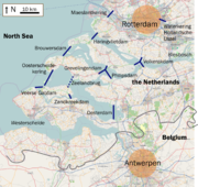
The Rhine–Meuse–Scheldt delta is a river delta in the Netherlands and Belgium formed by the confluence of the Rhine, the Meuse and the Scheldt rivers. The result is a multitude of islands, branches and branch names that may at first sight look bewildering, especially as a waterway that appears to...
from the sea. The works consist of dam
Dam
A dam is a barrier that impounds water or underground streams. Dams generally serve the primary purpose of retaining water, while other structures such as floodgates or levees are used to manage or prevent water flow into specific land regions. Hydropower and pumped-storage hydroelectricity are...
s, sluice
Sluice
A sluice is a water channel that is controlled at its head by a gate . For example, a millrace is a sluice that channels water toward a water mill...
s, locks
Lock (water transport)
A lock is a device for raising and lowering boats between stretches of water of different levels on river and canal waterways. The distinguishing feature of a lock is a fixed chamber in which the water level can be varied; whereas in a caisson lock, a boat lift, or on a canal inclined plane, it is...
, dikes
Levee
A levee, levée, dike , embankment, floodbank or stopbank is an elongated naturally occurring ridge or artificially constructed fill or wall, which regulates water levels...
, levee
Levee
A levee, levée, dike , embankment, floodbank or stopbank is an elongated naturally occurring ridge or artificially constructed fill or wall, which regulates water levels...
s, and storm surge barrier
Floodgate
Floodgates are adjustable gates used to control water flow in flood barriers, reservoir, river, stream, or levee systems. They may be designed to set spillway crest heights in dams, to adjust flow rates in sluices and canals, or they may be designed to stop water flow entirely as part of a levee or...
s. The aim of the dams, sluices, and storm surge barriers was to shorten the Dutch coastline, thus reducing the number of dikes that had to be raised.
Along with the Zuiderzee Works
Zuiderzee Works
The Zuiderzee Works are a manmade system of dams, land reclamation and water drainage works, the largest hydraulic engineering project undertaken by the Netherlands during the twentieth century. The project involved the damming of the Zuiderzee, a large, shallow inlet of the North Sea, and the...
, Delta Works have been declared one of the Seven Wonders of the Modern World by the American Society of Civil Engineers
American Society of Civil Engineers
The American Society of Civil Engineers is a professional body founded in 1852 to represent members of the civil engineering profession worldwide. It is the oldest national engineering society in the United States. ASCE's vision is to have engineers positioned as global leaders who strive toward...
.
History
The estuariesEstuary
An estuary is a partly enclosed coastal body of water with one or more rivers or streams flowing into it, and with a free connection to the open sea....
of the rivers Rhine, Meuse
Meuse River
The Maas or Meuse is a major European river, rising in France and flowing through Belgium and the Netherlands before draining into the North Sea...
and Scheldt
Scheldt
The Scheldt is a 350 km long river in northern France, western Belgium and the southwestern part of the Netherlands...
have been subject to flooding over the centuries. After building the Afsluitdijk
Afsluitdijk
The Afsluitdijk is a major causeway in the Netherlands, constructed between 1927 and 1933 and running from Den Oever on Wieringen in North Holland province, to the village of Zurich in Friesland province, over a length of and a width of 90 m, at an initial height of 7.25 m above sea-level.It is...
, the Dutch started studying the damming of the Rhine-Meuse Delta. Plans were developed for shortening the coastline and turning the delta into a group of freshwater lakes. By shortening the coastline fewer dikes would have to be reinforced.
Due to indecision and the Second World War
World War II
World War II, or the Second World War , was a global conflict lasting from 1939 to 1945, involving most of the world's nations—including all of the great powers—eventually forming two opposing military alliances: the Allies and the Axis...
, little action was taken. In 1950 two small estuary mouths, the Brielse Gat near Brielle
Brielle
Brielle , also called Den Briel is a town and municipality in the western Netherlands, in the province of South Holland, on the north side of the island of Voorne-Putten, at the mouth of the New Maas. The municipality covers an area of 31.12 km² of which 3.63 km² is water...
and the Botlek near Vlaardingen
Vlaardingen
Vlaardingen is a town in South Holland in the Netherlands. It is located on the north bank of the Nieuwe Maas/Nieuwe Waterweg river at the confluence with the Oude Maas...
were dammed. After the North Sea flood of 1953
North Sea flood of 1953
The 1953 North Sea flood was a major flood caused by a heavy storm, that occurred on the night of Saturday 31 January 1953 and morning of 1 February 1953. The floods struck the Netherlands, Belgium, England and Scotland.A combination of a high spring tide and a severe European windstorm caused a...
, a commission was installed which had to come up with a plan to research the causes and seek measures to prevent such disasters in future. They revised some of the old plans and came up with the so called "Deltaplan".
The plan consisted of blocking the estuary mouths of the Oosterschelde
Oosterschelde
The Oosterschelde is an estuary in Zeeland, Netherlands, between Schouwen-Duiveland and Tholen on the north and Noord-Beveland and Zuid-Beveland on the south.During the Roman Era it was the major mouth of the Scheldt River. Before the St...
, the Haringvliet
Haringvliet
The Haringvliet is a large inlet of the North Sea, in the province of South Holland in the Netherlands. It is an important estuary of the Rhine-Meuse delta.Near Numansdorp, the Hollands Diep splits into the Haringvliet and the Volkerak estuaries...
and the Grevelingen
Grevelingen
Grevelingen or Grevelingenmeer is a former Rhine-Meuse estuary on the border of the Dutch provinces of South Holland and Zeeland that has become a lake due to the Delta Works....
. This reduced the length of the dikes exposed to the sea by approximately 400 miles (643.7 km). The mouths of the Nieuwe Waterweg
Nieuwe Waterweg
The Nieuwe Waterweg is a ship canal in the Netherlands from het Scheur west of the town of Maassluis to the North Sea at Hook of Holland...
and the Westerschelde were to remain open because of the shipping routes to the ports of Rotterdam
Rotterdam
Rotterdam is the second-largest city in the Netherlands and one of the largest ports in the world. Starting as a dam on the Rotte river, Rotterdam has grown into a major international commercial centre...
and Antwerp
Port of Antwerp
The port of Antwerp, in Belgium, is a port in the heart of Europe accessible to capesize ships. Antwerp stands at the upper end of the tidal estuary of the Scheldt. The estuary is navigable by ships of more than 100,000 Gross Tons as far as 80 km inland. The inland location means that the port...
. The dikes along these waterways were to be heightened and strengthened. The works would be combined with road and waterway infrastructure to stimulate the economy of the province of Zeeland
Zeeland
Zeeland , also called Zealand in English, is the westernmost province of the Netherlands. The province, located in the south-west of the country, consists of a number of islands and a strip bordering Belgium. Its capital is Middelburg. With a population of about 380,000, its area is about...
and improve the connection between the port of Rotterdam and Antwerp.
Delta law and Conceptual framework
An important part of this project was fundamental research to help solve the flooding problem. Instead of analysing past floods and building protection sufficient to deal with those, the Delta Works commission pioneered a conceptual framework to use as norm for investment in flood defences.The framework is called the 'Delta norm' and works as follows:
- Major areas to be protected from flooding are identified. These are called "dike ring areas" because they are protected by a ring of primary sea defences.
- The cost of flooding is assessed using a statistical model involving damage to property, lost production and a given amount per human life lost.
- For the purpose of this model a human life is valued at €2.2 million (2008 data).
- The chances of a significant flood within the given area are calculated. This is done using data from a purpose-built flood simulation lab as well as empirical statistical data regarding water wave properties and distribution. Storm behaviour and spring tide distribution are also taken into account.
The most important "dike ring area" is the South Holland coast region. It is home to four million people, most of whom live below normal sea level.
The loss of human life in a catastrophic flood here can be very large because there is very little warning time with North Sea storms, and so comprehensive evacuation is not a realistic option for the Holland coastal region.
The commission initially set the acceptable risk for complete failure of every "dike ring" in the country at 1 in 125,000 years. However the cost of building this level of protection was deemed too high, so the acceptable risk was set according to region as follows:
- North and South Holland (excluding Wieringermeer): 1 per 10,000 years
- Other areas at risk from sea flooding: 1 per 4,000 years
- Transition areas between high land and low land: 1 per 2,000 years
River flooding causes less damage than salt water flooding so areas at risk from river flooding have a higher acceptable risk. River flooding also has a longer warning time, making for a lower estimated death toll.
- South Holland at risk from river flooding: 1 per 1,250 years
- Other areas at risk from river flooding: 1 per 250 years.
These acceptable risks were enshrined in the Delta law, requiring the government to keep risks of catastrophic flooding within these limits and to upgrade defences should new insights into risks require this.
These limits are also incorporated into the new Water Law, effective from 22 December 2009.
The Delta Project (of which the Delta Works are a part) has been designed with these guidelines in mind.
All other primary defences have been upgraded to meet the norm.
New data elevating the risk assessment on expected sea level rise due to global warming has brought ten 'weak points' to the fore. These are currently being upgraded to meet the future demands. This work is expected to be completed in 2015.
For rivers an upgrade is underway, which is expected to be finished in 2017.
Alterations to the plan during the execution of the Works
During the execution of the works alterations were made due to public pressure. In the Nieuwe Waterweg heightening and the associated widening of the dikes proved very difficult because of the historic buildings that would have to be destroyed. Therefore, a storm surge barrier would be built (the MaeslantkeringMaeslantkering
The Maeslantkering is a storm surge barrier in the Nieuwe Waterweg waterway located between the towns of Hoek van Holland and Maassluis, Netherlands, , which automatically closes when needed...
) and dikes were only partly built up.
The Oosterschelde was originally to be dammed and turned into a fresh water lake, leading to the loss of the saltwater ecosystem and, consequently, the harvesting of oysters. Environmentalists and fishermen combined their efforts to prevent the closure and successfully pressured parliament to amend the original plan. Instead of completely damming the estuary, a storm surge barrier would be built. This exists today as a collection of very large valves.
The storm surge barrier only closes when the sea-level is expected to rise 3 meters above mean sea level. Under normal conditions the estuary's mouth is open and salt water flows in and out with the tide. Consequently, the weak dikes along the Oosterschelde needed to be strengthened. This strengthening had not been done yet because the Oosterschelde would be dammed. Over 200 km of the dike needed new revetments. The connections between the Eastern Scheldt and the neighboring Haringvliet
Haringvliet
The Haringvliet is a large inlet of the North Sea, in the province of South Holland in the Netherlands. It is an important estuary of the Rhine-Meuse delta.Near Numansdorp, the Hollands Diep splits into the Haringvliet and the Volkerak estuaries...
had to be dammed to limit the effect of the salt water. Extra dams and locks were needed at the east part of the Oosterschelde to create a shipping route between the ports of Rotterdam and Antwerp.
Current status
The works were finished after almost fifty years in 1997 with the completion of the MaeslantkeringMaeslantkering
The Maeslantkering is a storm surge barrier in the Nieuwe Waterweg waterway located between the towns of Hoek van Holland and Maassluis, Netherlands, , which automatically closes when needed...
in the Nieuwe Waterweg
Nieuwe Waterweg
The Nieuwe Waterweg is a ship canal in the Netherlands from het Scheur west of the town of Maassluis to the North Sea at Hook of Holland...
between Maassluis
Maassluis
Maassluis is a town in the western Netherlands, in the province of South Holland. The municipality had a population of 32,847 in 2004, and covers an area of 10.11 km² .It received city rights in 1811...
and Hoek van Holland
Hoek van Holland
The Hook of Holland , also known in English as the Hook, is a town in South Holland in the Netherlands. It is situated on the North Sea coast, on the north bank of the Nieuwe Waterweg ship canal. The town is administered by the municipality of Rotterdam as a district of that city...
and the Hartelkering in the Hartel Canal near Spijkenisse
Spijkenisse
Spijkenisse is a town and municipality in the western Netherlands, in the province of South Holland. The municipality had a population of 74,482 in 2006, and covers an area of 30.23 km²...
.
In reality the works were finished on August 24, 2010 with the official opening of the last strengthened and raised retaining wall near the city of Harlingen, Netherlands
Harlingen, Netherlands
Harlingen is a municipality and a city in the northern Netherlands, in the province of Friesland at the Wadden Sea. Harlingen is an old town with a long history of fishing and shipping....
.
Due to climate change and relative sea-level rise, the dikes will eventually have to be made higher and wider. This is a long term uphill battle against the sea. The needed level of flood protection and the resulting costs are a recurring subject of debate. Currently, reinforcement of the dike revetments along the Oosterschelde and Westerschelde is underway. The revetments have proven to be insufficient and need to be replaced. This work started in 1996 and should be finished in 2015. In that period the Ministry of Public Works and Water Management in cooperation with the waterboards will have reinforced over 400 km of dikes.
In September 2008, the Delta commission presided by Dutch politician Cees Veerman
Cees Veerman
Cornelis Pieter Veerman is a Dutch politician of the Christian Democratic Appeal. He served as Minister of Agriculture, Nature and Food Quality from July 22, 2002 until February 22, 2007.-Early life:...
advised in a report that the Netherlands would need a massive new building program to strengthen the country's water defenses against the anticipated effects of global warming for the next 190 years. This commission was created in September 2007 after the damage caused by Hurricane Katrina
Hurricane Katrina
Hurricane Katrina of the 2005 Atlantic hurricane season was a powerful Atlantic hurricane. It is the costliest natural disaster, as well as one of the five deadliest hurricanes, in the history of the United States. Among recorded Atlantic hurricanes, it was the sixth strongest overall...
prompted reflection and preparations. Those included drawing up worst-case scenarios for evacuations. The plans included more than €100 billion, or $144 billion, in new spending through the year 2100 for measures, such as broadening coastal dunes and strengthening sea and river dikes
Levee
A levee, levée, dike , embankment, floodbank or stopbank is an elongated naturally occurring ridge or artificially constructed fill or wall, which regulates water levels...
.
The commission said the country must plan for a rise in the North Sea of 1.3 meters by 2100 and 4 meters by 2200.
Projects
The works that are part of the Delta Works are listed in chronological order with their year of completion:- Brielsegatdam (1950)
- Hollandse IJssel Storm Barrier Stormvloedkering Hollandse IJssel (1958)
- Zandkreekdam (1960)
- Veersegatdam (1961)
- Grevelingendam (1965)
- Volkerakdam (1969)
- Haringvliet sluices Haringvlietdam (1971)
- Brouwersdam (1971)
- Markiezaatskade (1983)
- Eastern Scheldt Storm Surge BarrierOosterscheldekeringThe Oosterscheldekering , between the islands Schouwen-Duiveland and Noord-Beveland, is the largest of the 13 ambitious Delta works series of dams, designed to protect the Netherlands from flooding...
Oosterscheldekering (1986) - Oesterdam (1987)
- PhilipsdamPhilipsdamPhilipsdam belongs to the Delta Plan. After this cette construction, water of the lakes Krammer and Volkerak are separated from the Oosterschelde. This dam connects the Grevelingendam to Sint Philipsland....
(1987) - Bathse Spuisluis (1987)
- Hartel BarrierHartelkeringThe Hartelkering is a storm surge barrier in Spijkenisse, in the Netherlands. The barrier is part of the Delta Works and is designed to close the Hartelkanaal in case of a storm surge....
Hartelkering (1997) - Maeslant BarrierMaeslantkeringThe Maeslantkering is a storm surge barrier in the Nieuwe Waterweg waterway located between the towns of Hoek van Holland and Maassluis, Netherlands, , which automatically closes when needed...
Maeslantkering (1997) - Harlingen water retaining wall Harlingenkeerdam (2010)
See also
- Flood control in the NetherlandsFlood control in the NetherlandsFlood control in the Netherlands is an important issue for the Netherlands as about two thirds of the country is vulnerable to flooding while at the same time the country is among the most densely populated on earth. Natural sand dunes and man made dikes, dams and floodgates provide defense against...
- Lauwerszee WorksLauwersmeerLauwersmeer is a man-made lake in the north of the Netherlands, on the border of the provinces of Groningen and Friesland. The lake was formed on 1969-05-23, when the dike between the bay called "Lauwers Sea" and the Wadden Sea was closed....
- MegaprojectMegaprojectA megaproject is an extremely large-scale investment project. Megaprojects are typically defined as costing more than US$1 billion and attracting a lot of public attention because of substantial impacts on communities, environment, and budgets. Megaprojects can also be defined as "initiatives that...
- Thames BarrierThames BarrierThe Thames Barrier is the world's second-largest movable flood barrier and is located downstream of central London. Its purpose is to prevent London from being flooded by exceptionally high tides and storm surges moving up from the sea...
- Zuiderzee WorksZuiderzee WorksThe Zuiderzee Works are a manmade system of dams, land reclamation and water drainage works, the largest hydraulic engineering project undertaken by the Netherlands during the twentieth century. The project involved the damming of the Zuiderzee, a large, shallow inlet of the North Sea, and the...